Loading...

WINTER SALE! 50% OFF Supporter Accounts — now through January 31st. Learn More.

Crabtree Falls Hike

The Crabtree Meadows Campground not only offers a perfect jumping off point to explore Linville Gorge and the Black Mountains, it also has a nice 3.0 mile loop to the beautiful Crabtree Falls. Although this loop has a few steep spots of stairs and switchbacks, this should be manageable for all types of hikers with a little determination.

You can choose to hike the full loop or take the shortest route to the waterfall and back. Once you reach the base of Crabtree Falls you’ll want to stay a while. The waterfall slides 20 feet before falling 50 feet over many small ledges into a narrow plunge pool hidden from the trail. The view is beautiful from the bridge, but it is easy to explore both sides of the waterfall. Since this hike is short you may consider combining it with another waterfall in the area like Linville Falls for a perfect day trip.    

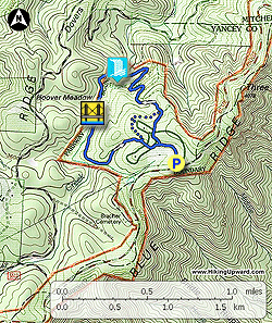
Parking Note: If the campground is open you can park at the hikers parking lot beside the trail head. This will make the hike only 2.5 miles.

  • Mile 0.0 – From the restaurant/amphitheater parking lot start the trail at the beginning of the lot heading towards the amphitheater.
  • Mile 0.2 – After you pass by the amphitheater the paths split towards Loop A and Loop B campgrounds. Stay right going towards the road.
  • Mile 0.3 – Cross the campground road veering right towards the hikers parking lot. The Crabtree Falls Loop Trail officially begins at the end of the hikers parking lot.
  • Mile 0.5 – T-junction with the loop trail. Turn right for the shorter trek to the waterfall. The trail starts heading downhill towards the Big Crabtree Creek Gorge.
  • Mile 0.7 – Trail begins to switchback more steeply down the mountain sometimes following large sets of stairs.
  • Mile 1.2 – Reach a bridge over Big Crabtree Creek at the base of Crabtree Falls. This picturesque waterfall slides 20-30 feet before cascading 50 feet over many small ledges. On either side of the waterfall you can walk to the base where a narrow pool remains hidden from the bridge view.

    Continue on the loop trail as it switchbacks high away from the waterfall.

  • Mile 1.6 – The trail follows below a band of high rocks on its way to a perilous cliff overlook of the waterfall and gorge.
  • Mile 2.0 – Bridge over Big Crabtree Creek. The trail briefly follows the creek on the left side before turning east following a tributary back to the campground.
  • Mile 2.4 – The loop trail turns left. Continue straight towards the campground and cross the road near the bathrooms to meet up with the trail near the amphitheater.
  • Mile 2.7 – Hike ends at the restaurant parking lot.
By HikingUpward Contributor: Zach Robbins
Explore 40 trails near Micaville, NC

Know Before You Go

  • Crabtree Falls Trail near Micaville, NC, offers a 2.7-mile loop (or shorter option) to a scenic waterfall with a 70-80ft cascade and hidden plunge pool.
  • The hike is generally manageable, with some steep sections of stairs and switchbacks, and can be shortened by parking at the hiker's lot.
  • The waterfall is a highlight, accessible from both sides, and the hike can be combined with other nearby attractions like Linville Falls for a full day trip.
Interactive topographic map for Crabtree Falls Hike located in Micaville, NC. Click the "View Map" button to load GPS coordinates and trail markers.
Get directions
Distance
2.7 mi
Difficulty
Easy
Type
Loop
Est. Time
1.4 hrs
Elev. Gain
700'
Rating
0.0
Added
March 22, 2025
Updated
April 06, 2025

Weather Forecast

Loading...
Total Change
519'
Ascent
700'
Descent
700'
Loading...

Download the GPX Data for Offline Use

Supporters get exclusive access to download trail routes to the MyHikes app for offline use. Stay prepared on your adventure, even without an internet connection! Become a Supporter today to unlock this feature and hike with confidence.

Download Crabtree Falls Hike GPX Data to the MyHikes Mobile App

Features

Dogs
Waterfalls
Camping
Water Source

Points of interest

  1. Parking

    35.812558, -82.143359
  2. Main Trailhead

    35.812558, -82.143359

Safety information

For your own safety: plan ahead, let someone know where you'll be, and hike at your own risk.

Hazards

Snakes (Rattlesnakes, Copperheads, others)
Poison Ivy or Poison Oak

Availability

All seasons

Surface type

Dirt

Trip Reports (Reviews)

Your opinion matters! Be the first to rate this trail.

Ready to help fellow hikers? Add a trip report to share your experience and provide valuable insights for other hikers!

No community routes found. To add your own hike as a Community Route for this Trail guide, leave a Trip Report with an attached GPX file.

Popular categories

Scenic mountain view representing vista trails
Vista trails
Scenic gorge of cascades representing waterfall trails
Waterfall hikes
Rugged mountain terrain representing summit trails
Summit trails
Scenic mountain view representing dog-friendly trails
Dog-friendly
Scenic campsite with a view representing camping trails
Camping trails
Appalachian Trail logo representing A.T. hikes
A.T. hikes

You May Also Like

25 Best Day Hikes in North Carolina - Discover the top 25 best day hikes in North Carolina, from breathtaking waterfalls to mountain peaks. Explore hidden gems, scenic views, and trails suitable for all skill levels, perfect for your next outdoor adventure.
Explore

25 Best Day Hikes in North Carolina

Discover the top 25 best day hikes in North Carolina, from breathtaking waterfalls to mountain peaks. Explore hidden gems, scenic views, and trails suitable for all skill levels, perfect for your next outdoor adventure.

Read
Colorado's Million Dollar Highway - Plan a day's drive adventure along the iconic Million Dollar Highway in Colorado. Explore the best short trails, roadside stops, waterfalls, vistas, ghost towns, and hot springs within a ~6 hour road trip.
Explore

Colorado's Million Dollar Highway

Plan a day's drive adventure along the iconic Million Dollar Highway in Colorado. Explore the best short trails, roadside stops, waterfalls, vistas, ghost towns, and hot springs within a ~6 hour road trip.

Read
Glacier's Going-to-the-Sun Road - Discover the breathtaking beauty of Glacier National Park along the iconic Going-to-the-Sun Road. From stunning roadside stops to picturesque waterfalls and vistas, this engineering marvel offers endless opportunities for exploration.
Explore

Glacier's Going-to-the-Sun Road

Discover the breathtaking beauty of Glacier National Park along the iconic Going-to-the-Sun Road. From stunning roadside stops to picturesque waterfalls and vistas, this engineering marvel offers endless opportunities for exploration.

Read
🍪 We use cookies to learn about site usage and to serve map tiles. You may block cookies manually in the browser. By continuing you agree. Learn more