Loading...

❄️ WINTER SALE! 50% OFF on Supporter Accounts — now through January 31st. Unlock a full year of exclusive website & app perks. Learn More.

Cowee Bald Lookout Tower Hike

The Cowee Bald lookout tower was originally built in 1933, making it one of the oldest remaining towers in the state. Considering its age, the tower is in surprisingly good condition. Cowee Bald is the third tallest peak (4,944 feet) in the Cowee Mountains, only surpassed by Shortoff Mountain and Yellow Mountain, the home of another lookout tower. From the stairs of the 30-foot tower you will have limited views north of the Plott Balsam Mountains and south of the Little Tennessee River Valley. The top cab is normally locked, but if you happen to join a hiking group with keys you will have outstanding views of western North Carolina. Cowee Bald is the highest point in the remote, ring-shaped Cowee-Alarka complex, where lonely forest roads meander through the backwoods between major mountain highways. This tower is not easy to reach, especially for smaller cars. It involves a long drive on FR 70 from Franklin and the final few miles on FR 70 are overgrown and eroded. The drive south on FR 86 from Whittier is worse. There are many confusing forest road intersections, erosion and potholes, and two creek fords; one of which has a steep slope for a small vehicle. This hike is not recommended unless you are trying to finish the Carolina Lookout Tower Challenge. Additionally, one or more gates will be locked during the winter meaning a hike to the summit could be many miles.      

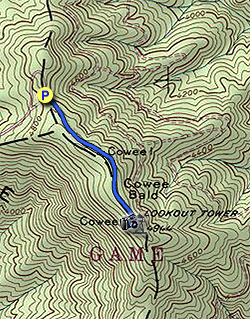
  • Mile 0.0 – Park at the wide turnaround area before you reach the gate on FR 70. Follow the gravel FR 70 southeast towards the summit of Cowee Bald.
  • Mile 0.4 – At the summit of Cowee Bald you’ll pass by a large complex of communication towers on the left.

    Mile 0.55 – The gravel road continues past the communication towers ending in a field in front of the Cowee Bald lookout tower. The tower was built in 1933 and remains in good condition, but the top cab is normally locked. The trees are somewhat cleared around the tower, so you can get a decent view from the stairs. Franklin lies to the southwest in the Little Tennessee River Valley, surrounded by the Cowee Mountains to the east and the Nantahala Mountains to the west. The Plott Balsam Mountains dominate the skyline to the immediate northeast. The tallest peak in the middle of the range is Waterrock Knob, with Browning Knob and Mt. Lyn Lowry the two tall peaks immediately to the right. Further north the Great Smoky Mountains rise beyond Maggie Valley. Through the tower supports you can see the Great Balsam Mountains to the northeast.

  • Mile 1.1 – Hike ends at the turnaround on FR 70.
By HikingUpward Contributor: Zach Robbins
Explore 30 trails near Big Laurel, NC

Know Before You Go

  • Cowee Bald Lookout Tower, built in 1933, is a historic but difficult-to-access fire tower offering limited views from its stairs unless you can access the locked top cab.
  • The 1.1-mile hike to the tower is short, but the remote location and challenging drive on rough, eroded forest roads make it unsuitable for all vehicles, especially small ones, and may be inaccessible in winter.
  • Despite the limited views and difficult access, the tower offers panoramas of the Plott Balsam Mountains, Little Tennessee River Valley, and glimpses of other ranges, making it a worthwhile destination primarily for those completing the Carolina Lookout Tower Challenge.
Interactive topographic map for Cowee Bald Lookout Tower Hike located in Big Laurel, NC. Click the "View Map" button to load GPS coordinates and trail markers.
Get directions
Distance
1.1 mi
Difficulty
Easy
Type
Out-and-Back
Est. Time
33 min
Elev. Gain
158'
Rating
0.0
Added
March 20, 2025
Updated
April 06, 2025

Weather Forecast

Loading...
Total Change
142'
Ascent
158'
Descent
154'
Loading...

Download the GPX Data for Offline Use

Supporters get exclusive access to download trail routes to the MyHikes app for offline use. Stay prepared on your adventure, even without an internet connection! Become a Supporter today to unlock this feature and hike with confidence.

Download Cowee Bald Lookout Tower Hike GPX Data to the MyHikes Mobile App

Features

Vista / Lookout Point
Dogs
Mountain Summit

Points of interest

  1. Parking

    35.332578, -83.340377
  2. Main Trailhead

    35.332578, -83.340377

Safety information

For your own safety: plan ahead, let someone know where you'll be, and hike at your own risk.

Hazards

Snakes (Rattlesnakes, Copperheads, others)
Poison Ivy or Poison Oak

Availability

All seasons

Surface type

Dirt

Trip Reports (Reviews)

Your opinion matters! Be the first to rate this trail.

Ready to help fellow hikers? Add a trip report to share your experience and provide valuable insights for other hikers!

No community routes found. To add your own hike as a Community Route for this Trail guide, leave a Trip Report with an attached GPX file.

Popular categories

Scenic mountain view representing vista trails
Vista trails
Scenic gorge of cascades representing waterfall trails
Waterfall hikes
Rugged mountain terrain representing summit trails
Summit trails
Scenic mountain view representing dog-friendly trails
Dog-friendly
Scenic campsite with a view representing camping trails
Camping trails
Appalachian Trail logo representing A.T. hikes
A.T. hikes

You May Also Like

25 Best Day Hikes in North Carolina - Discover the top 25 best day hikes in North Carolina, from breathtaking waterfalls to mountain peaks. Explore hidden gems, scenic views, and trails suitable for all skill levels, perfect for your next outdoor adventure.
Explore

25 Best Day Hikes in North Carolina

Discover the top 25 best day hikes in North Carolina, from breathtaking waterfalls to mountain peaks. Explore hidden gems, scenic views, and trails suitable for all skill levels, perfect for your next outdoor adventure.

Read
Colorado's Million Dollar Highway - Plan a day's drive adventure along the iconic Million Dollar Highway in Colorado. Explore the best short trails, roadside stops, waterfalls, vistas, ghost towns, and hot springs within a ~6 hour road trip.
Explore

Colorado's Million Dollar Highway

Plan a day's drive adventure along the iconic Million Dollar Highway in Colorado. Explore the best short trails, roadside stops, waterfalls, vistas, ghost towns, and hot springs within a ~6 hour road trip.

Read
Glacier's Going-to-the-Sun Road - Discover the breathtaking beauty of Glacier National Park along the iconic Going-to-the-Sun Road. From stunning roadside stops to picturesque waterfalls and vistas, this engineering marvel offers endless opportunities for exploration.
Explore

Glacier's Going-to-the-Sun Road

Discover the breathtaking beauty of Glacier National Park along the iconic Going-to-the-Sun Road. From stunning roadside stops to picturesque waterfalls and vistas, this engineering marvel offers endless opportunities for exploration.

Read
🍪 We use cookies to learn about site usage and to serve map tiles. You may block cookies manually in the browser. By continuing you agree. Learn more