Loading...

❄️ WINTER SALE! 50% OFF on Supporter Accounts — now through January 31st. Unlock a full year of exclusive website & app perks. Learn More.

Cove Creek Falls Hike

FR 475 along the Davidson River in Pisgah National Forest is loaded with popular trails and rewarding destinations. Cove Creek Falls, a splendid 50-foot waterfall, is within earshot of the Cove Creek Group Camp. This waterfall hike is not lengthy or difficult, making it a good choice for beginner hikers or those looking to combine multiple waterfalls in one day. Although there are some twists and turns at the beginning near the campground, trails and signs point the way. Additionally, there's a nice 15-foot waterfall beside the forest road before you reach the campground. While you’re in the area, consider hiking Pilot Mountain or John Rock and Cedar Rock Falls.

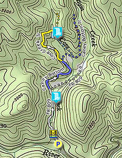
  • Mile 0.0 – Begin at the parking area on FR 475 at the T-junction with FR 809, located beside the bridge over Cove Creek. FR 809 is the access road for the Cove Creek Group Camp, but parking at the campground is reserved for campers only and is also locked during the winter.

  • Mile 0.1 – FR 809 fords Cove Creek. Turn right on an alternate trail leading to a footbridge over the creek. Rejoin FR 809 on the other side of the creek.

  • Mile 0.3 – A steep scramble trail on the right leads to the base of an unnamed 15-foot waterfall on Cove Creek.

  • Mile 0.45 – At a Y-junction turn left beginning the Caney Bottom Trail [361] (blue blaze).
    (Note – this section of the Caney Bottom Trail is open to mountain bikers.)

  • Mile 0.55 – Turn right at a T-junction crossing a small stream to continue following the Caney Bottom Trail. An unofficial trail goes straight connecting with the Daniel Ridge Trail. The trail swings around the perimeter of Cove Creek Group Camp.
  • Mile 0.8 – Continue straight on the Cove Creek Trail [340] (yellow blaze) at a T-junction where the Caney Bottom Trail turns right. (Note – the Cove Creek Trail is open to mountain bikers.) The trail begins climbing around the left side of a dry cove.

  • Mile 1.2 – Turn right on a side path marked with a Cove Creek Falls brown carsonite sign. The trail initially passes near the top of the waterfall. Avoid exploring this area, there is not much room at the top and a fall could be fatal. Follow the path downstream, which swings wide and curves back to the left towards the base.

  • Mile 1.3 – Reach the base of Cove Creek Falls. The creek cascades over colorful, bare rock more than 50 feet into a shallow pool at the base.

  • Mile 2.4 – Hike ends at FR 475.
By HikingUpward Contributor: Zach Robbins
Explore 17 trails near Brevard, NC

Know Before You Go

  • Cove Creek Falls is an easily accessible 50-foot waterfall hike in Pisgah National Forest, suitable for beginners.
  • The 2.4-mile trail involves some initial navigation near Cove Creek Group Camp and includes a 15-foot waterfall along the way.
  • The route follows FR 475, Caney Bottom Trail, and Cove Creek Trail, with clear signage directing hikers to the falls and potential hazards near the waterfall's top.
Interactive topographic map for Cove Creek Falls Hike located in Brevard, NC. Click the "View Map" button to load GPS coordinates and trail markers.
Get directions
Distance
2.4 mi
Difficulty
Easy
Type
Out-and-Back
Est. Time
1.2 hrs
Elev. Gain
520'
Rating
0.0
Added
March 13, 2025
Updated
April 05, 2025

Weather Forecast

Loading...
Total Change
343'
Ascent
520'
Descent
517'
Loading...

Download the GPX Data for Offline Use

Supporters get exclusive access to download trail routes to the MyHikes app for offline use. Stay prepared on your adventure, even without an internet connection! Become a Supporter today to unlock this feature and hike with confidence.

Download Cove Creek Falls Hike GPX Data to the MyHikes Mobile App

Features

Dogs
Waterfalls
Water Source

Points of interest

  1. Parking

    35.283007, -82.816843
  2. Main Trailhead

    35.283007, -82.816843

Safety information

For your own safety: plan ahead, let someone know where you'll be, and hike at your own risk.

Hazards

Snakes (Rattlesnakes, Copperheads, others)
Poison Ivy or Poison Oak

Availability

All seasons

Surface type

Dirt

Trip Reports (Reviews)

Your opinion matters! Be the first to rate this trail.

Ready to help fellow hikers? Add a trip report to share your experience and provide valuable insights for other hikers!

No community routes found. To add your own hike as a Community Route for this Trail guide, leave a Trip Report with an attached GPX file.

Popular categories

Scenic mountain view representing vista trails
Vista trails
Scenic gorge of cascades representing waterfall trails
Waterfall hikes
Rugged mountain terrain representing summit trails
Summit trails
Scenic mountain view representing dog-friendly trails
Dog-friendly
Scenic campsite with a view representing camping trails
Camping trails
Appalachian Trail logo representing A.T. hikes
A.T. hikes

You May Also Like

25 Best Day Hikes in North Carolina - Discover the top 25 best day hikes in North Carolina, from breathtaking waterfalls to mountain peaks. Explore hidden gems, scenic views, and trails suitable for all skill levels, perfect for your next outdoor adventure.
Explore

25 Best Day Hikes in North Carolina

Discover the top 25 best day hikes in North Carolina, from breathtaking waterfalls to mountain peaks. Explore hidden gems, scenic views, and trails suitable for all skill levels, perfect for your next outdoor adventure.

Read
Colorado's Million Dollar Highway - Plan a day's drive adventure along the iconic Million Dollar Highway in Colorado. Explore the best short trails, roadside stops, waterfalls, vistas, ghost towns, and hot springs within a ~6 hour road trip.
Explore

Colorado's Million Dollar Highway

Plan a day's drive adventure along the iconic Million Dollar Highway in Colorado. Explore the best short trails, roadside stops, waterfalls, vistas, ghost towns, and hot springs within a ~6 hour road trip.

Read
Glacier's Going-to-the-Sun Road - Discover the breathtaking beauty of Glacier National Park along the iconic Going-to-the-Sun Road. From stunning roadside stops to picturesque waterfalls and vistas, this engineering marvel offers endless opportunities for exploration.
Explore

Glacier's Going-to-the-Sun Road

Discover the breathtaking beauty of Glacier National Park along the iconic Going-to-the-Sun Road. From stunning roadside stops to picturesque waterfalls and vistas, this engineering marvel offers endless opportunities for exploration.

Read
🍪 We use cookies to learn about site usage and to serve map tiles. You may block cookies manually in the browser. By continuing you agree. Learn more