Loading...

🍂 Prep for Fall! Unlock exclusive features to plan your perfect late-summer and autumn hikes — become a Supporter today. Learn more.

Corbin Mountain Hike

Directions
Map
Pictures
Send to App
Distance:
11.3 Miles / 18.2 km
Type:
Loop
Difficulty:
Hard
Time to Hike:
5 hours, ~39 minutes
Features:
Surface Type:
Dirt
Park:
Shenandoah National Park
Town:
Etlan, Virginia
Directions:
38.57111, -78.288488
Added:
March 18, 2025
Updated:
April 05, 2025
Guide by:
Copy Trail Link Hiking this trail? Send a friend or family member a link to this trail guide for your own safety. Hike at your own risk (disclaimer)
Loading...
Loading...
2,266'

Total Change
2,396'

Ascent
2,395'

Descent

Download the Trail Route for Offline Use

Supporters get exclusive access to download trail routes to the MyHikes app for offline use. Stay prepared on your adventure, even without an internet connection! Become a Supporter today to unlock this feature and hike with confidence.

Send to App

Key Takeaways

  • The Corbin Mountain Hike is an 11.3-mile loop near Etlan, VA, accessible from the parking area on Route 600 and closely related to the Nicholson Hollow hike.
  • The trail passes notable landmarks including Corbin Cabin, involves steep ascents via the Indian Run Trail, and features junctions with trails like Nicholson Hollow, Hot Mountain/Short Mountain, Hannah Run, and Corbin Mountain.
  • The hike incorporates sections of the Old Rag Fire Road, Corbin Hollow Trail, and Weakley Hollow Fire Road, with multiple river crossings and a final stretch along Route 600 back to the parking area.

Corbin Mountain Hike

One of three great hikes in the area, Old Rag Mountain Hike, Catlett Mountain Hike, and the Nicholson Hollow Hike this is the longer loop version of the Nicholson Hollow out/back hike. The hike passes Corbin Cabin and climbs over Corbin Mountain.

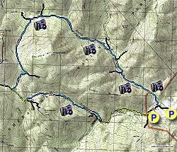
From the parking area on 600 it is a 0.5 mile walk up to the Nicholson Hollow Trail) Turn left, then immediately right and in 75 yards cross Brokenback Run and Hughes River.

Continue up the Nicholson Hollow Trail passing the Corbin Mountain Trail on your left in 1.1 miles. In another 0.2 miles pass the Hot Mountain/Short Mountain Trail that merges from the right.

Continue on the Nicholson Hollow Trail re-crossing Hughes River then passing the Hannah Run Trail in 0.3 miles, cross Hughes River again and follow the Nicholson Hollow Trail for another 1.8 miles and arrive at Corbin Cabin. In another 0.2 miles past Corbin Cabin the Indian Run Trail enters from the left.

Turn left on the Indian Run Trail where the trail becomes steep for the next for 1.6 miles where it ends at the junction of the Corbin Mountain Trail. Turn right on the Corbin Mountain Trail following it for 0.5 miles to the junction of the Old Rag Fire road.

Turn left on the Old Rag Fire Road for 0.5 miles to the intersection of the Corbin Hollow Trail. Turn left on the Corbin Hollow Trail as it descends following Brokenback run for 2.0 miles before crossing Brokenback Run then again at the intersection of the Weakley Hollow Fire Road.

Turn left on the Weakley Hollow Fire Road for remaining 1.2 miles to the beginning of the loop and upper Old Rag Parking area at SR600. continue for 0.4 miles, veer right at the Nicholson Hollow Trail post and continue down SR600 for the remaining 0.5 miles back to the parking area.
Explore 74 trails near Etlan, VA
  1. Parking

    38.57111, -78.288488
  2. Main Trailhead

    38.570951, -78.286901
No community routes found. To add your own hike as a Community Route for this Trail guide, leave a Trip Report with an attached GPX file.

Hazards

Ticks - Lyme Disease More Info (CDC)
Snakes
Poison Ivy/Oak

Seasons

All

Photo Albums

+ Add Photo Album

Upload your photos from the trail to help others know what to expect.

Trip Reports (Reviews)

Rated 3.57 out of 5 based on 14 ratings.
By: FrankJ
11.3 miles / 18.2 km
May 20, 2017
Hiked counterclockwise beginning at 7:50am on a humid morning with temps in the 70s. Rain the previous day and evening brought up the river water levels to a point where some stepping rocks were underwater, so add'l care was needed at most crossings to avoid slipping. Corbin Cabin on the climb was a nice place to take a snack. We hiked at a reasonably good pace and arrived at the cabin at 9:30am. The climb past the cabin to the max elevation was a bit grueling at our pace (for me), but an excellent workout to the ridge. On the other side of the ridge we stopped at the ledge overlook for a quick lunch before the steady downward climb. Unfortunately this is one of those hikes where there is no significantly rewarding destination, such as a waterfall, swimming hole, or mountain peak with grand vistas. Corbin cabin and the ledge overlook are nice stopping points but certainly not grand. Finished in less than five hours including snack and lunch break.
Legacy Review
By: Mike G
11.3 miles / 18.2 km
April 05, 2015
Had a pleasant early spring hike with the first bit of warm weather this year to break in some new boots. Lots of people were going up Old Rag but the Corbin Hollow and Indian Run Trails were nearly deserted. Ran into a large herd of deer crossing the Old Rag fire road and descending into Corbin Hollow. Bloodroot flowers were starting to emerge along sections of trail and you could tell that everything was going to erupt with blossoms and greenery in the next week or so. Definitely a nice option for a less strenuous stroll through the woods!
Legacy Review
By: Kellygirl
11.3 miles / 18.2 km
July 19, 2014
Completed this loop in the opposite direction as posted. It was cool and overcast day in July! I had to take advantage of that! The hike was not difficult and easier going in the direction I took. I'm glad I didn't do Old Rag..it was full of tourists! This is a good hike for people who want to increase their hiking miles.
Legacy Review

Weather Forecast

In Etlan, VA

Explore Hiking Trails

You May Also Like

New York's Best Waterfalls - Whether you're planning a day hike, roadside stop, or a leisurely short walk, this guide provides hikers, travelers, and locals alike with 63 different locations to over 100 scenic waterfalls to help plan your next adventure!
Explore

New York's Best Waterfalls

Whether you're planning a day hike, roadside stop, or a leisurely short walk, this guide provides hikers, travelers, and locals alike with 63 different locations to over 100 scenic waterfalls to help plan your next adventure!

Read
25 Best Day Hikes in North Carolina - Discover the top 25 best day hikes in North Carolina, from breathtaking waterfalls to mountain peaks. Explore hidden gems, scenic views, and trails suitable for all skill levels, perfect for your next outdoor adventure.
Explore

25 Best Day Hikes in North Carolina

Discover the top 25 best day hikes in North Carolina, from breathtaking waterfalls to mountain peaks. Explore hidden gems, scenic views, and trails suitable for all skill levels, perfect for your next outdoor adventure.

Read

Before you boogie...

Find our trail guides useful? Consider becoming a Supporter to unlock perks!

MyHikes is an indie platform that makes exploring public trails easier for everyone. The platform has no investors, no ads, and is owned and operated by one person, Dave Miller. Dave has personally mapped and written over 1,800 trail guides on MyHikes for the public to explore. MyHikes has helped millions outdoor enthusiasts plan their next adventure.

But it takes a lot of time 🕦, money 💰, work, and espresso shots ☕ to run MyHikes, including hiking , mapping , writing , and publishing new trails with high-quality (accurate) information... along with software engineering (coding) the platform like building new features, website and mobile app development (iOS and Android), site maintainance . and much much more.

Supporters unlock website and mobile app perks with an annual one-time payment of $25 (you renew) 😎👍. Or you can simply make a Donation of your choice. Otherwise, you can support us by telling your friends about MyHikes - both quick and free 🎉

Admin user profile picture

Dave Miller
MyHikes Founder