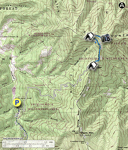
Cold Mountain is a classic summit hike in the North Carolina Blue Ridge Mountains made infamous by the novel and movie Cold Mountain. The peak stands alone at the northern border of the Shining Rock Wilderness in Pisgah National Forest, and looks formidable from a distance. The shortest hike begins at Camp Daniel Boone with the Art Loeb Trail, climbing over 2,800 feet to the summit in 5.2 miles. This is a strenuous hike undertaken by many due to its infamy, and due to the wonderful views from the summit. As you climb you’ll pass by occasional old-growth and second-growth hardwood trees with a splendid mixture of wildflowers during the Spring season. Deep Gap is an excellent camping area and marks the junction of the Art Loeb Trail and Cold Mountain Trail around 5,000 feet. From here, the Cold Mountain Trail climbs over 1,000 feet in 1.3 miles to the lofty heights of Cold Mountain. At the summit, you’ll have panoramic views of the Shining Rock and Middle Prong Wilderness Areas which are home to the tallest peaks in the Great Balsam Mountains. There are also outstanding campsites near the top of the mountain further away from possible congestion at Deep Gap.
Wilderness Regulations – Group size is limited to 10 persons within the Shining Rock Wilderness Area. Campfires are prohibited, a wilderness-specific regulation that is not prohibited in other wilderness areas of North Carolina. Additionally, bear canisters are now required for all backcountry campers. No overnight permits are required to camp year-round. Trails are not officially blazed within the wilderness, and not every official trail intersection is signed. However, the Art Loeb Trail and Cold Mountain Trail have occasional white and red blazes. These are not officially sanctioned by the forest service, and they may not be there when you hike.
- Mile 0.0 – The northern terminus of the Art Loeb Trail (ALT) is located directly before Little East Fork Rd crosses the bridge over Little East Fork. The wide shoulder of the road is reserved for hikers, but this may be full during the summer. If the shoulder is full, you may have to backtrack and ask the Camp Daniel Boone staffers if you can park in one of their parking lots. In the winter this shouldn’t be an issue. The Art Loeb Trail [146] (no blaze) heads northeast from the road, immediately entering the Shining Rock Wilderness and switchbacking through rocky terrain.
- Mile 1.0 – Y-junction with an old forest road on the right.
- Mile 1.1 – The ALT makes an eastward turn and passes by a small campsite on the left.
- Mile 2.0 – Cross a tributary of Sorrell Creek.
- Mile 2.35 – Cross a second tributary of Sorrell Creek. Before you reach this crossing there is a campsite below the trail.
- Mile 2.5 – Small campsite on the left side of the trail.
- Mile 2.9 – Cross a third tributary of Sorrell Creek. This and the fourth tributary crossing are probably your best trailside water sources if you are camping at Deep Gap.
- Mile 3.0 – Cross a fourth tributary of Sorrell Creek. The trail gets noticeably rockier and steeper beyond this point.
- Mile 3.4 – Cross a fifth tributary of Sorrell Creek. This is your last water source before you reach Deep Gap and is low-flow.
- Mile 3.5 – Campsite on a hill well below the trail to the north. Below this campsite on the right is a spring.
- Mile 3.8 – The Art Loeb Trail reaches Deep Gap and turns right heading south. There are numerous flat campsites scattered around the gap. Turn left following the Cold Mountain Trail [141] (no blaze) north. Deep Gap is around the 5,000-foot elevation contour and lies more than 1,000 feet below the peak. The trail initially climbs up the ridge then levels out with winter views of the southern cliffs of Cold Mountain.
- Mile 4.3 – The trail takes a northwest turn and steeply climbs up the south flank of the mountain.
- Mile 4.6 – A piped spring is located on the trail, the origin of Sorrell Creek. This is a low-flow spring so filling up here may take a while.
- Mile 4.7 – Take a right turn in a saddle between the summit and the western subpeak. There are multiple nice campsites beside the trail. The final approach to the summit is through a beautiful, gnarled forest of northern hardwoods.
- Mile 5.05 – Beginning of spiny summit crest with constant southern views. The trail hangs onto the steep, barren slope of Cold Mountain. Numerous rock outcrops on the right side of the trail provide panoramic views from east to west of the Great Balsam Mountains. Looking south, Shining Rock Ledge makes up the crest of the central Great Balsam Mountains. Down to the left is the Crawford Creek watershed, a major tributary of the East Fork of the Pigeon River. Deep Gap and The Narrows are far below the summit immediately south. Stairs Mountain and Shining Rock are the blackish peaks due south above The Narrows, covered in spruce and balsam fir. Dog Loser Knob is the heath bald on the left side of Shining Rock, part of the Old Butt Knob Trail and Chestnut Ridge. Further south, the broad summit is Black Balsam Knob and the double-humped summit on the right is Sam Knob. To the right of Sam Knob is Mount Hardy and the leading Fork Ridge. Towards the southwest are the watersheds of Little East Fork and West Fork of the Pigeon River divided by the Fork Mountain massif. Richland Balsam, the tallest peak in the range, is the double-humped peak furthest southwest.
- Mile 5.15 – Cross the true summit of Cold Mountain (6,030 feet), with the USGS survey marker embedded in a boulder. The views from here are not comparable to the prior 0.1-mile. Continue east to the end of the trail.
- Mile 5.2 – The Cold Mountain Trail peters out immediately east of the summit. From here you’ll have a good view east of Mount Pisgah. Turn around and follow the Cold Mountain Trail down the mountain.
- Mile 6.7 – Turn right on the Art Loeb Trail.
- Mile 9.9 – Hike ends at Little East Fork Rd.