Loading...

🎉 Enjoy a Free 7-Day Supporter Trial and Unlock Exclusive Perks — No Credit Card Required. Learn more.

Chocolate Drop Vista

Directions
Map
Pictures
Send to App
Distance:
0 Miles / 0 km
Type:
Out-and-Back
Difficulty:
Easy
Time to Hike:
~5 minutes
Features:
Surface Type:
Universal Access
Park:
Bald Eagle State Forest
Town:
Coburn, Pennsylvania
Directions:
40.83226, -77.451146
Added:
July 07, 2024
Updated:
July 29, 2024
Copy Trail Link Hiking this trail? Send a friend or family member a link to this trail guide for your own safety. Hike at your own risk (disclaimer)
Loading...

Download the Trail Route for Offline Use

Supporters get exclusive access to download trail routes to the MyHikes app for offline use. Stay prepared on your adventure, even without an internet connection! Become a Supporter today to unlock this feature and hike with confidence.

Send to App

Chocolate Drop Vista

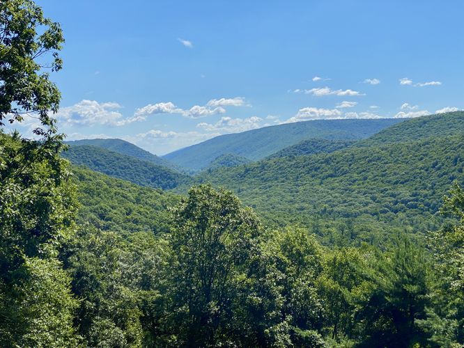
Chocolate Drop Vista at Bald Eagle State Forest near Coburn, Pennsylvania is a roadside view that provides visitors with a vista of the mountains that surround Poe Paddy State Park and Poe Valley State Park, including Ravens Knob.

This is not a hike but rather a short roadside stop to scenic mountain views in the state forest. No walking is required if you wish to enjoy this view from your vehicle, hence this view is also universally accessible.

Exploring Nearby
Despite not being a hike, this is a great roadside view to stop at if you plan to explore the mountains within Bald Eagle State Forest near Poe Paddy State Park and Poe Valley State Park. Additionally, you shouldn't miss out on the cool old railroad tunnel, Poe Paddy Tunnel located just down the street. If you wish to explore further, you can drive to the Ravens Knob Vistas for a short 0.1-mile hike for more views of the area.

Parking
Visitors will find a small parking turnout at the coordinates provided, located on Pine Swamp Road within the forest.

Pets
Dogs are allowed only if leashed and must be cleaned up after.
Explore 29 trails near Coburn, PA
  1. Parking

    40.83226, -77.451146
  2. Main Trailhead

    40.83226, -77.451146
  3. Mountain view from the Chocolate Drop Vista

    40.832275, -77.451064
    Mountain view from the Chocolate Drop Vista
No community routes found. To add your own hike as a Community Route for this Trail guide, leave a Trip Report with an attached GPX file.

Hazards

Ticks - Lyme Disease More Info (CDC)
Snakes

Seasons

All

Photo Albums

Trip Reports

Trail Guide By:
Admin user profile picture
0 miles / 0 km
0 miles / 0 km
July 07, 2024
Dogs Hiking
0 miles / 0 km
October 16, 2021
Excellent view, and nicer getting to see with Fall Foliage near peak! This forest road drive is really nice, so continue up to the even more amazing Penn's View. Did this after doing Poe Paddy Tunnel hike, then after driving up to see the vistas, continued over to the Coburn Tunnel which was really cool too!
Hiking

Weather Forecast

In Coburn, PA

Explore Hiking Trails

You May Also Like

Colorado's Million Dollar Highway - Plan a day's drive adventure along the iconic Million Dollar Highway in Colorado. Explore the best short trails, roadside stops, waterfalls, vistas, ghost towns, and hot springs within a ~6 hour road trip.
Explore

Colorado's Million Dollar Highway

Plan a day's drive adventure along the iconic Million Dollar Highway in Colorado. Explore the best short trails, roadside stops, waterfalls, vistas, ghost towns, and hot springs within a ~6 hour road trip.

Read
New York's Best Waterfalls - Whether you're planning a day hike, roadside stop, or a leisurely short walk, this guide provides hikers, travelers, and locals alike with 63 different locations to over 100 scenic waterfalls to help plan your next adventure!
Explore

New York's Best Waterfalls

Whether you're planning a day hike, roadside stop, or a leisurely short walk, this guide provides hikers, travelers, and locals alike with 63 different locations to over 100 scenic waterfalls to help plan your next adventure!

Read

Before you boogie...

Find our trail guides useful? Consider becoming a Supporter to unlock perks!

MyHikes is an indie platform that makes exploring public trails easier for everyone. The platform has no investors, no ads, and is owned and operated by one person, Dave Miller. Dave has personally mapped and written over 1,800 trail guides on MyHikes for the public to explore. MyHikes has helped millions outdoor enthusiasts plan their next adventure.

But it takes a lot of time 🕦, money 💰, work, and espresso shots ☕ to run MyHikes, including hiking , mapping , writing , and publishing new trails with high-quality (accurate) information... along with software engineering (coding) the platform like building new features, website and mobile app development (iOS and Android), site maintainance . and much much more.

Supporters unlock website and mobile app perks with an annual one-time payment of $25 (you renew) 😎👍. Or you can simply make a Donation of your choice. Otherwise, you can support us by telling your friends about MyHikes - both quick and free 🎉

Admin user profile picture

Dave Miller
MyHikes Founder