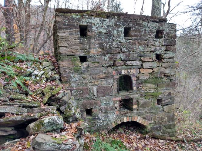
A CCC-Era Stone Incinerator (at least that is the most recent likely purpose of this Cross Fork, Pennsylvania historical point of interest) can be found in the purlieus of the Ole Bull Castle site. Near to the intersection of Joerg Road and Ole Bull Road, there is an old stone relic, likely used by the Ole Bull Civilian Conservation Corps (CCC) camp as a disposal method for burning waste material.
At first, the thought was that this structure could have been an oven or fireplace for the Recreation Hall for the Ole Bull S-87-PA Camp. Similar to the Chimney on the State Camp CCC S-76 Trail, which is one of the known Rec Hall Chimney still "standing" in this region; according to Richard Wykoff from the Clinton County PA CCC Program. The other known standing Rec Hall chimney that was part of the Rec Hall for the CCC S-133 Hammersley Fork can be seen on the "F.H. Dutlinger Old Growth Forest Hike" south of the Beech Bottom Trail junction. The stone structure at the Ole Bull S-76 camp, has more of an square box appearance, and definitely different shape than the other two more traditional log-cabin style fireplaces. Also, it's location along the road, and "over the bank" make it seem more likely to an Incinerator.
Trails
This structure is located just off of the Joerg Road, and can be seen from the public roadway.
Hike Description
This structure is located just off of the Joerg Road, and can be seen from the public roadway. No real hiking is required to visit this old oven.
Parking
Hikers will find a small parking turnout near by the coordinates provided. The turnout is enough for 1 vehicle but no more without blocking traffic on the Joerg Road (which could include large log trucks).
Do not block the public use of the Joerg Road, or any of the privately-leased cabin access roads, or any of the yellow-gated forest service roads in the area.
Pets
This structure is located just off of the Joerg Road, and is not dog-friendly.
Biking
Biking is allowed along all of these multi-use trails and roads in the area except for the STS. Additionally, horses are not allowed along the STS.
Camping and Backpacking
Although camping is allowed along trails in the Susquehannock State Forest, PA where state forest rules permit backcountry / dispersed / primitive camping. This structure just off of the Joerg Road, and is not suitable for Camping and Backpacking. The Susquehannock Trail System aka STS is by far the best place to camp in this area; but it would be best for the camper to park at another pre-defined parking area for any extended hikes or overnight camping trips.
Hikers can find a large parking turnout near a yellow gate along the Twelve Mile Rd. where the STS crosses the Twelve Mile Rd. See Big Trestle Trail for extended trip parking coordinates and details.
History and Historical Points of Interest
Castle Vista Trail Ole Bornemann Bull (1810 - 1880), a once-famous Norwegian violinist, relocated a colony of fellow Norwegians near the site in September 1852. From this vantage point (Nordjeuskald), Ole Bull started to build his castle, but this large wooden cabin was never completed. All that remains today is the foundation and a stone retaining wall along the mountainside. The colony disbanded and moved west after a year of severe hardships.
Dense forests of magnificent white pine, hemlock and hardwoods grew here in Potter County for many decades. In the late 1800's and early 1900's, industrial saw mills, tanneries, and chemical plants were established, using wood or bark as raw materials which brought rapid population increases. As the hillsides became barren, the population spiraled downward with much of the deforested timberland abandoned, Before than, Native Americans had passed through the forested wilderness.
Ole Bull State Park was established in 1920. The CCC camp located in the Kettle Creek watershed opened in the 1933 under the designation Ole Bull S-87-PA. Its servicemen constructed picnic shelters, dammed the creek for swimming, and assisted local foresters in fire control and reforestation of the land. The Camp Ole Bull closed in 1941. The CCC camps provided the pretrained troops to fill the ranks upon this country's mobilization into World War II in that same year, and many of the CCC servicemen readily assumed the role of Non-Commissioned Officers (NCO) in the US Army.