The F. H. Dutlinger Old Growth Forest Hike at Susquehannock State Forest's Forrest H. Dutlinger Natural Area, which sits within the Hammersley Wild Area, near Cross Fork, Pennsylvania is a moderate 5.9-mile out-and-back hike that leads to an untouched old growth forest of mostly Hemlocks - one of a few old growth forests left on the east coast - where the trees measure in around 310 years old as of Spring, 2021.
Trails
This hike follows two named trails: Hammersley Fork Trail (aka Hammersley Road), Beech Bottom Trail.
Hike Description
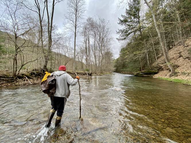
This trek begins along Hammersley Road, where hikers will find a small parking turnout just before the creek crossing at Hammersley Fork creek. Hikers will need to get their feet wet or come prepared with waders since the trail immediately crosses Hammersley Fork creek before following a mostly-dry path that heads north along the creek and past, what appear to be, private camps. This section of the hike follows - what's depicted on the Hammersley Wild Area map - as yellow blazes; however, most of these blazes aren't visible until you reach the Beech Bottom Trail.
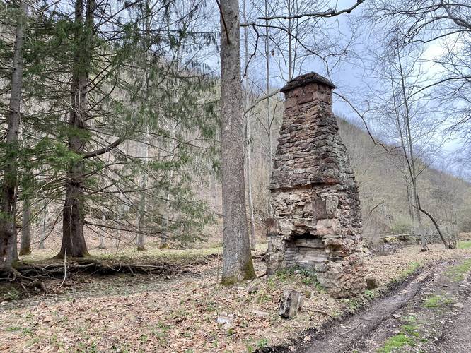
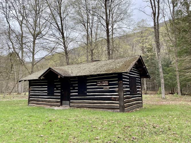
The Young Dutchmen Cabin & Abandoned Chimney - mile 1
Around mile 1, hikers will reach an old cabin that was built in 1952 named The Young Dutchmen. Just across from this cabin, which I think is more interesting, is an old chimney that once belonged to an old log cabin that no longer exists. This chimney sticks out alongside the trail as a historical marker, but there's no additional information about either The Young Dutchmen or the chimney.
Beech Bottom Trail Trailhead - mile 1.3
Around mile 1.3, hikers will reach the trailhead for the Beech Bottom Trail. This is where the F. H. Dutlinger Natural Area begins along with the uphill hike to reach the old growth hemlock grove.
Hikers will follow the Beech Bottom Trail westward while heading uphill through Beech Bottom Hollow. The trail's grade is mostly moderate, until you reach a slightly steeper grade around mile 1.9. After reaching this steeper grade, hikers will be only 0.4 miles from the actual old growth hemlock grove.
Old Growth Hemlock Grove - miles 2.3 to 2.5
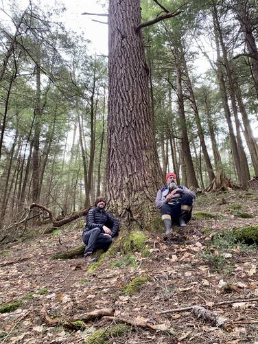
Between miles 2.3 to 2.5, hikers will walking alongside ancient old growth hemlock trees near the top of Beech Bottom Hollow. Some of these trees tower over 100-feet above the forest floor. Some of the largest trees in this grove appear to be 4-feet or more in diameter. According to Wikipedia, the largest tree is 112-feet tall and 47-inches wide; however, this data might be old as of Spring 2021. At the end of this trek data, around mile 2.5, hikers will find a trail registry box which was donated by Camp Triple B (BBB) located off-trail on the hike in along Hammersley Fork creek. Sign in here!
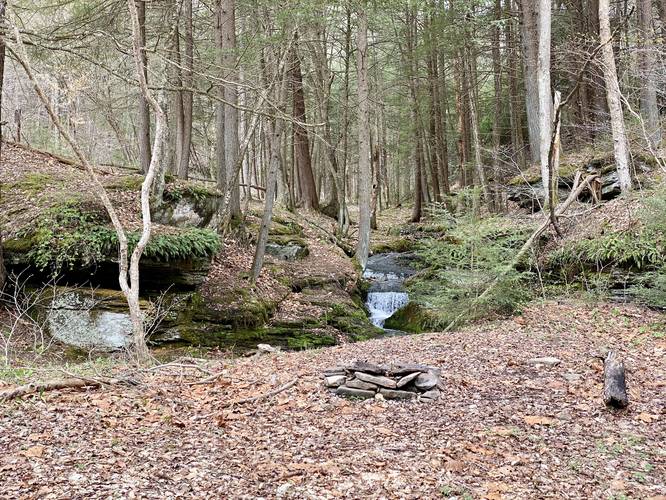
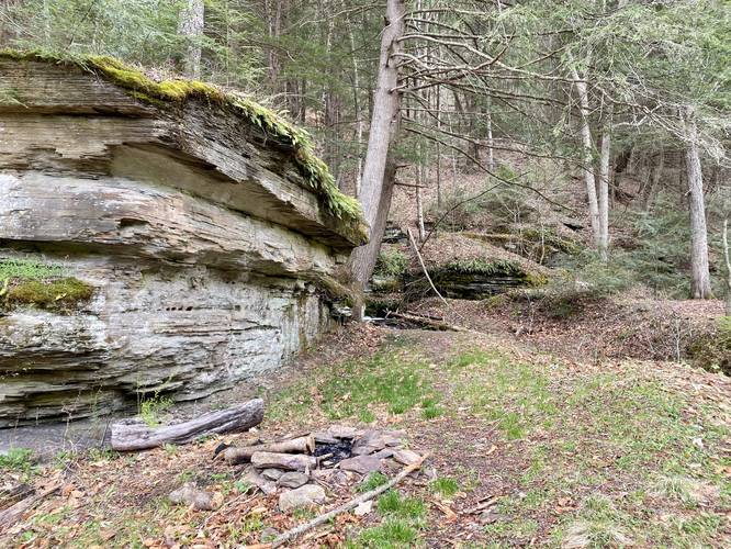
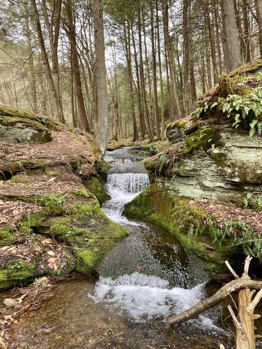
Campsites and Waterfall Cascade
After visiting the old growth grove, hikers may want to check out a small waterfall with a couple of adjacent campsites. The waterfall can be found next to the rock ledges near the Beech Bottom Trail trailhead at the junction with the Hammersley Fork Trail. These campsites and this small waterfall can be found just 1.3 miles into the hike on your way in or around mile 3.6 on your hike out.
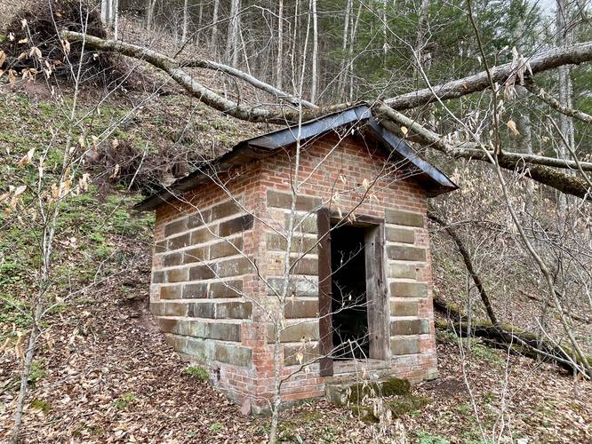
Old Dynamite Shed
After checking out the small waterfall and campsites, hikers may want to explore one more point-of-interest before heading out - an old dynamite shed. This old dynamite shed is located just off-trail of the Hammersley Fork Trail north of the Beech Bottom Trail junction. To reach this old dynamite shed, hikers will trek north following yellow blazes - while wading in and out of Hammersley Fork creek several times to reach the shed. Around mile 4, hikers will find the shed at the bottom of the hillside, just off-trail (left, if facing north).
After reaching the dynamite shed, this trek ends and heads back to the parking area for a 5.9-mile out-and-back hike.
Parking
Hikers will find a small parking area at the coordinates provided.
Pets
Dogs are allowed if leashed; however, depending on the size of your dog and the time of year, it might be best to leave your furry friend at home because of the initial deeper creek crossing along Hammersley Fork creek at the beginning of the hike.
Camping and Backpacking
Backpackers will find a couple of campsites along this hike, mostly around the Hammersley Fork Trail. Please follow all dispersed / primitive / backcountry camping rules and regulations that the state forest has in place.
Difficulty
This trail is not all that difficult in terms of elevation gain; however, there are sections of the Beech Bottom Trail that will not be easy and will get you sweating. The difficulty mostly lies within the steeper grade along the Beech Bottom Trail and the creek crossings.
Warnings
Rattlesnakes: The Timber Rattlesnake tends to come down to creeks to cool down or hunt between the end of April through the end of September. Watch your step and give any rattlesnake you see some space.
Creek crossings: This trek requires the hiker to cross creeks several times. Come prepared with the proper footwear and gear. Trekking poles are also helpful when crossing Hammersley Fork creek during the Spring.
History & Old Growth Hemlock Size / Age
This section of forest was an unlogged area that apparently resulted from a surveying error between the boundaries of the Goodyear and Lackawanna Lumber companies, resulting in a land dispute. Eventually the logging industry collapsed before a resolution to the dispute was found. Ever since then, the trees continue to tower over this section of forest. The trees have been treated by the state of Pennsylvania against the hemlock wooly adelgid, a nonnative invasive insect. The trees we found were massive - over 3-feet in diameter, if not almost 4-feet in diameter. After coming back on a separate hike, we measured the largest tree (located on-trail) to be approximately 3.955-feet in diameter with a 150 inch circumference. 150 inches equates to ~121.27606663602425 cm in D.b.h (diameter at breast height), which converts to ~310 years old (Eastern Hemlock aging guide). Some sources, like Wikipedia, claim the largest tree here is 47-inches (3.91-feet) in diameter and 112-feet tall; however, this data is likely outdated as of Spring 2021. Please see our uploaded pictures for an idea of the scale of some of these trees - pictured are Hemlocks.
Trails
This hike follows two named trails: Hammersley Fork Trail (aka Hammersley Road), Beech Bottom Trail.
Hike Description
This trek begins along Hammersley Road, where hikers will find a small parking turnout just before the creek crossing at Hammersley Fork creek. Hikers will need to get their feet wet or come prepared with waders since the trail immediately crosses Hammersley Fork creek before following a mostly-dry path that heads north along the creek and past, what appear to be, private camps. This section of the hike follows - what's depicted on the Hammersley Wild Area map - as yellow blazes; however, most of these blazes aren't visible until you reach the Beech Bottom Trail.
The Young Dutchmen Cabin & Abandoned Chimney - mile 1
Around mile 1, hikers will reach an old cabin that was built in 1952 named The Young Dutchmen. Just across from this cabin, which I think is more interesting, is an old chimney that once belonged to an old log cabin that no longer exists. This chimney sticks out alongside the trail as a historical marker, but there's no additional information about either The Young Dutchmen or the chimney.
Beech Bottom Trail Trailhead - mile 1.3
Around mile 1.3, hikers will reach the trailhead for the Beech Bottom Trail. This is where the F. H. Dutlinger Natural Area begins along with the uphill hike to reach the old growth hemlock grove.
Hikers will follow the Beech Bottom Trail westward while heading uphill through Beech Bottom Hollow. The trail's grade is mostly moderate, until you reach a slightly steeper grade around mile 1.9. After reaching this steeper grade, hikers will be only 0.4 miles from the actual old growth hemlock grove.
Old Growth Hemlock Grove - miles 2.3 to 2.5
Between miles 2.3 to 2.5, hikers will walking alongside ancient old growth hemlock trees near the top of Beech Bottom Hollow. Some of these trees tower over 100-feet above the forest floor. Some of the largest trees in this grove appear to be 4-feet or more in diameter. According to Wikipedia, the largest tree is 112-feet tall and 47-inches wide; however, this data might be old as of Spring 2021. At the end of this trek data, around mile 2.5, hikers will find a trail registry box which was donated by Camp Triple B (BBB) located off-trail on the hike in along Hammersley Fork creek. Sign in here!
Campsites and Waterfall Cascade
After visiting the old growth grove, hikers may want to check out a small waterfall with a couple of adjacent campsites. The waterfall can be found next to the rock ledges near the Beech Bottom Trail trailhead at the junction with the Hammersley Fork Trail. These campsites and this small waterfall can be found just 1.3 miles into the hike on your way in or around mile 3.6 on your hike out.
Old Dynamite Shed
After checking out the small waterfall and campsites, hikers may want to explore one more point-of-interest before heading out - an old dynamite shed. This old dynamite shed is located just off-trail of the Hammersley Fork Trail north of the Beech Bottom Trail junction. To reach this old dynamite shed, hikers will trek north following yellow blazes - while wading in and out of Hammersley Fork creek several times to reach the shed. Around mile 4, hikers will find the shed at the bottom of the hillside, just off-trail (left, if facing north).
After reaching the dynamite shed, this trek ends and heads back to the parking area for a 5.9-mile out-and-back hike.
Parking
Hikers will find a small parking area at the coordinates provided.
Pets
Dogs are allowed if leashed; however, depending on the size of your dog and the time of year, it might be best to leave your furry friend at home because of the initial deeper creek crossing along Hammersley Fork creek at the beginning of the hike.
Camping and Backpacking
Backpackers will find a couple of campsites along this hike, mostly around the Hammersley Fork Trail. Please follow all dispersed / primitive / backcountry camping rules and regulations that the state forest has in place.
Difficulty
This trail is not all that difficult in terms of elevation gain; however, there are sections of the Beech Bottom Trail that will not be easy and will get you sweating. The difficulty mostly lies within the steeper grade along the Beech Bottom Trail and the creek crossings.
Warnings
Rattlesnakes: The Timber Rattlesnake tends to come down to creeks to cool down or hunt between the end of April through the end of September. Watch your step and give any rattlesnake you see some space.
Creek crossings: This trek requires the hiker to cross creeks several times. Come prepared with the proper footwear and gear. Trekking poles are also helpful when crossing Hammersley Fork creek during the Spring.
History & Old Growth Hemlock Size / Age
This section of forest was an unlogged area that apparently resulted from a surveying error between the boundaries of the Goodyear and Lackawanna Lumber companies, resulting in a land dispute. Eventually the logging industry collapsed before a resolution to the dispute was found. Ever since then, the trees continue to tower over this section of forest. The trees have been treated by the state of Pennsylvania against the hemlock wooly adelgid, a nonnative invasive insect. The trees we found were massive - over 3-feet in diameter, if not almost 4-feet in diameter. After coming back on a separate hike, we measured the largest tree (located on-trail) to be approximately 3.955-feet in diameter with a 150 inch circumference. 150 inches equates to ~121.27606663602425 cm in D.b.h (diameter at breast height), which converts to ~310 years old (Eastern Hemlock aging guide). Some sources, like Wikipedia, claim the largest tree here is 47-inches (3.91-feet) in diameter and 112-feet tall; however, this data is likely outdated as of Spring 2021. Please see our uploaded pictures for an idea of the scale of some of these trees - pictured are Hemlocks.