A hike is a learning experience. What can the hiker learn on this hike; The one thing that CCC camps have in common is that they were all unique.
The ruins of the foundations for the buildings that once accommodated Company 1330 are now surrounded by a mature Red Pine plantation. This site also holds CCC-era features that distinguish it from others. In addition to ruins, the hiking trails of Camp S-76 have informative signs with the purpose of the buildings and structures that once stood here. Two creek crossings are needed on this hike. These sections have foot bridges to help the hiker cross the creeks and marshy areas. These designs enhance hiker experience and were the trail projects of Eagle Scouts Nick Mitchell and Logan Naspinski, of Troop 370 of Bellefonte, Pennsylvania.
Near the trailhead stand a camp memorial stone and an interpretive display to recognize the contributions of State Camp S-76. These exhibits were contributed by the Greater Renovo Area Heritage Parks and Pennsylvania Lumber Heritage Region.
Trails
This hike explores the Site of State Camp S-76. The trail is to easy-to-follow but nevertheless a-tad-hard-to-find each of the various building and structure sites that once were the CCC camp. The Camp S-76 informative signs with the purpose of the buildings and structures, the trail foot bridges and yellow blaze marks help guide the hiker.
Hike Description
This hike begins to the northeast near the parking area at the end of Middle Branch Road at the "Site of State Camp S-76 1933-1941" trailhead sign.
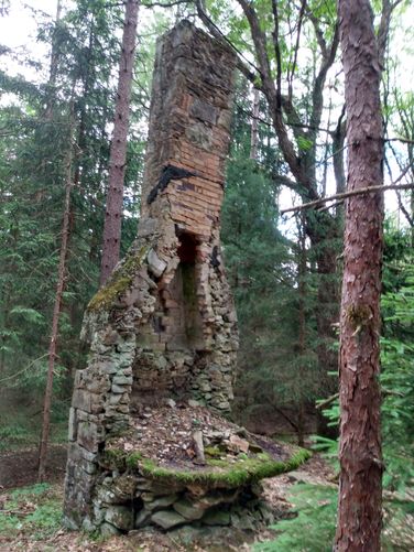
Recreation Hall/Administration Building Ruins: Begin the hike to the southwest for less than 100 feet to the site of the Recreation Hall located on the left (lower) side of the road. The most prominent feature at this site is ruins of the chimney and fireplace hearth. The tour group learned that the "Abandoned chimney" on the "F.H. Dutlinger Old Growth Forest Hike" was part of the Recreation Hall for the CCC S-133 Hammersley Fork Camp. Similar to this Chimney on the Camp S-76 hike, it is the other (one of two) known Rec Hall Chimney still "standing" in this region; according to Richard Wykoff from the Clinton County PA CCC Program (who was part of our tour group on the CCC camp S-76 hike).
From here, the hike continues to the southwest for another 200 feet to the site of the Administration Building. This site is located on the right (upper) side of the road. The hiker uses the original stair steps to climb up to the site of the ruins for the Headquarters that once commanded Company 1330. The location above the Barracks and Rec Hall once gave the company leaders an overview of the entire campus.
Infirmary/Barracks Ruins: The hiker returns along the road and heads back to the northeast for a short distance, to follow the trail that leads to the right (lower) side of the road heading to the southeast. This trail section runs between two rows of Barrack buildings that once housed Company 1330. The first foundation ruin to the left was the Infirmary, and the remaining five foundation ruins were the barracks. The scale of the ruins show the space needed to house up to 100 civilian enrollees who comprised the unit.
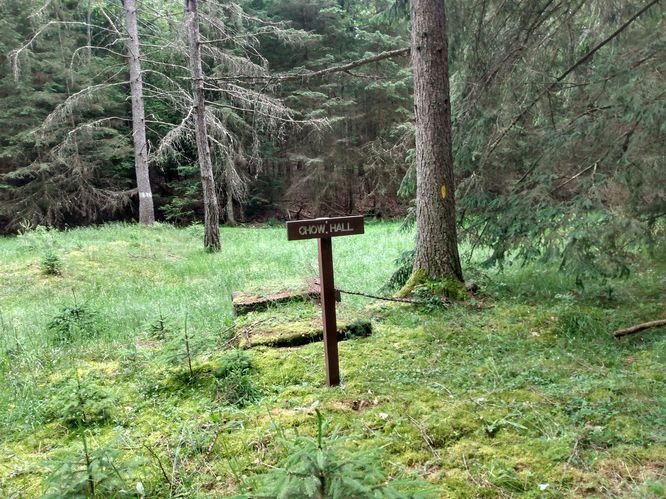
Chow Hall/Shower House Ruins: The trail continues downhill to the southeast to the Chow (Mess) Hall ruins. It has been estimated that each worker required 5000 calories daily to preform the hard work demanded to be a CCC enrollee. The spring source for the the small creek that runs behind Chow Hall was likely used for fresh potable water for the camp. After visiting the Chow Hall ruins, the hiker turns to the right and follows the marked trail to the southwest. At this point in the hike, the hiker can also turn to the left, and return to the trailhead.
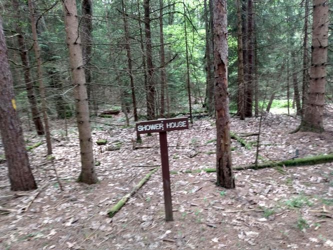
Following the trail to southwest (downhill) for about 200 feet leads the hiker to the site of the ruins of the Shower House. Here can be seen the ruins with steel water pipes at the ground level that were once used to at this facility. It appears the water was piped from the nearby creek running from the northeast ravine behind the Shower House location.
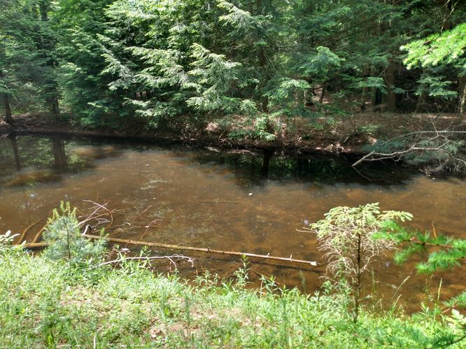
Swimming Pool/Equipment Building Ruins: The trail continues downhill tuning more southerly for about 500 feet through a pine forest making two creek crossings to location of the camp's swimming pool. The trail has foot bridges to help the hiker cross over the creeks and marshy areas. The swimming pool appears to have been fed at one time by another small creek running fresh spring water from the nearby northwest hollow (different water source than used for the Chow Hall and Shower House). At this point in the hike, the hike turns to the right and begins to go uphill to the north back toward the gravel road. Within about 500 feet, the hiker reaches the location of the Equipment Building ruins. Likely this location was used for storing the camp's trucks and hand tools (rakes, shovels, firefighting equipment). The CCC camps used worker muscle power for the most part to complete their projects.
From here, the hiker continues on the marked trail to the north for another 500 feet. Turning right on the gravel road leads the hiker back to the parking area.
There are no camping opportunities at the Site of State Camp S-76.
Backpackers are allowed to camp within the Sproul State Forest. Backpackers need to follow the state forest rules and regulations for dispersed / primitive / back-country camping. The Chuck Keiper Trail is the best place to backpack in this area; but it would be best for the camper to park at another defined parking area for any extended hikes or overnight camping trips.
Road Conditions & Winter Maintenance The roads that lead to this trail are narrow gravel roads and may not have any winter maintenance. The site of State Camp S-76 is about 2 miles from PA State Highway 144, also know as Breeze Avenue.The secondary roads are Penrose Road and Middle Branch Road.
Parking: Parking can be found at the coordinates. The trails can be access from here. There is a recognition sign "Site of State Camp S-76 1933-1941" at the trailhead. There's enough space for only 1 or 2 cars at the parking area near the trailhead. Hikers will find parking at the coordinates provided that is about 2 miles driving distance from PA State Highway 144, also know as Breeze Avenue.
Pets: Dogs are allowed if leashed.
Blaze colors: Marked with yellow blazes. Trail designed for foot traffic (non-motorized vehicles).