The Cass Trail to Wellsboro Overlook at Tioga State Forest is a strenuous 1.3-mile out-and-back trail that leads to a stunning vista point with 180-degree views of the Wellsboro area including the surrounding mountains, a view toward Mansfield, PA and a view of the Armenia Mountain Wind Farm near Troy, PA when the skies are clear.
Overgrowth Warning
As of 2022, this trail is overgrown near the top of the mountain where the clear-cut logging area happened in 2021. Unfortunately no one has maintained the trail and some recent hikers (July, 2023) noted that the views are starting to fill in.
Hike Description
This is a very strenuous trail, so hikers should come prepared. In the winter, ice spikes are a must-have or else it's impossible to hike this trail. Trekking poles are recommended as well as most of the trail follows a very steep grade.
Hikers will begin at the unmarked trailhead (see notes below on how to locate the trailhead), and they'll hike along an unmarked, unblazed trail that has pink ribbons lining the path. These ribbons exist every 400-feet or so. The trail is easy enough to follow - just continue hiking in the main cut-out between the conifer trees.
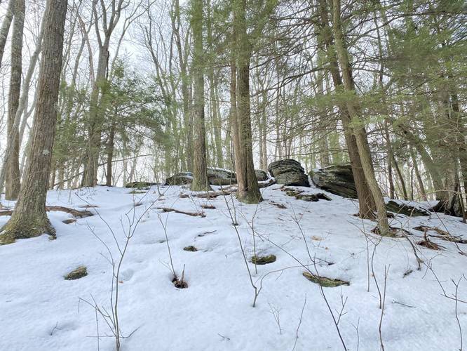
Whale's Backbone Rock Outcropping
Hikers will reach the top of the mountain around mile 0.4 and just before the end of the climb up is a rock outcropping that I've nicknamed the Whale's Backbone. These rocks jut out of the ground with spacing between them - making the appear as though they're the top notches of a whale's backbone. Here, the hiker knows the hard part is over and the payout is about to begin.
After reaching the top of the mountain, the hiker can do one of two things: hike straight along the edge of the clear-cut forest until reaching the service road (Oak Ridge Trail), or hike through the clear-cut forest following tread marks. This recording does the latter and passes through the clear-cut forest and over to the lookout.
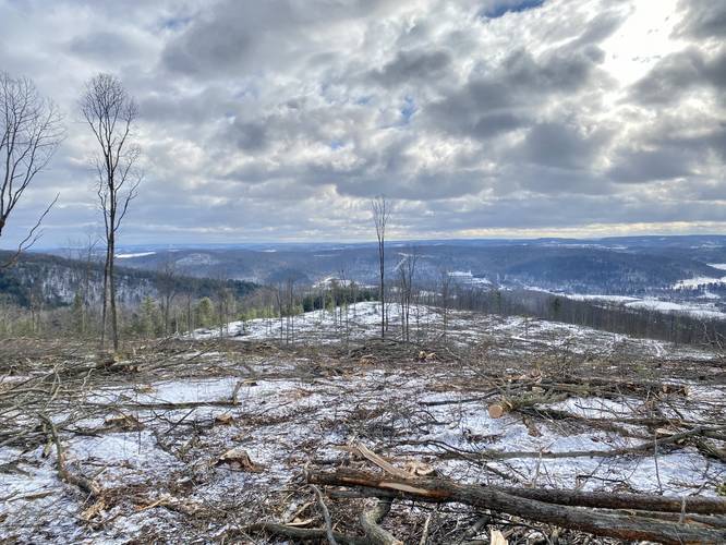
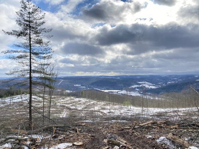
Wellsboro Overlook
At mile 0.6 to 0.7, the hiker will finally reach the edge of the mountain's clear-cut area - what I've nicknamed the Wellsboro Overlook. This overlook / vista is a near-180-degree view that encompasses the entire town of Wellsboro and the surrounding mountains. This overlook was clear-cut in late December 2020 or very early January 2021, hence at the time of this recording this vista was brand new. Other than the planners and loggers, no one else has really been up here to enjoy this stunning view of Wellsboro. Hikers should also note that if the state forest does not plan to keep this area clear and free, the vista will be reclaimed by the forest in the years to come.
Hiking back to parking is identical to the hike up. Hikers can choose to follow the service road (Oak Ridge Trail) out toward the edge of the clear-cut forest and then down the Cass Trail. Or the hiker can pass through the clear-cut forest to reach the downward slope of the Cass Trail. Either way, take your time heading downhill - especially in Autumn and after it's rained as the trail will be extremely slippery. Again trekking poles will likely help.
Parking
Hikers will find there is no good place to park for this trailhead. I found parking by the gas pipeline cutout along Baldwin Run Road in Wellsboro - at the coordinates provided; however, there's enough space for about 2 vehicles. Do not block any access gates when parking here.
Trailhead Sign Non-Existant
As of January 2021, the trailhead sign for the Cass Trail does not exist. In fact, it's very difficult to find this trail unless you're used to searching for unmarked, unblazed, lightly-trafficked trails. The easiest way to find it is by starting at the gas pipeline cutout, head west along Baldwin Run Road for approximately 100-feet. Look to your left-hand side (looking up the mountain) and there should be a clear-cut space between conifer trees. This is your trail. Hikers will find pink ribbons lining the trail, every 400-feet or so.
Camping and Backpacking
This trail allows for backpacking but there are no places to camp (yet) as of January 2021. Logging is still an active thing happening in this location, but all logging should be done by Spring 2021. There are no designated campsites but backpackers should be able to find a place to setup camp after clearing out debris.
Pets
Dogs are allowed if leashed.
Mountain Summit
This trail does climb a mountain, but there is no true mountain summit at the top. This feature exists on this trail for those looking for a difficult hike that climbs a mountain.
Timber Rattlesnake
Please keep in mind the Timber Rattlesnake lives in these parts. They tend to live near rocky outcroppings and sunbathe themselves in open vistas. This trail, between late April and late September, may be a good habitat for rattlesnakes. Be on the lookout and listen for rattlers. Give them their distance if you see one.
Blaze Color
This trail is marked as red blazes on the map; however, as of January 2021, hikers will find pink ribbons along this trail instead.
Overgrowth Warning
As of 2022, this trail is overgrown near the top of the mountain where the clear-cut logging area happened in 2021. Unfortunately no one has maintained the trail and some recent hikers (July, 2023) noted that the views are starting to fill in.
Hike Description
This is a very strenuous trail, so hikers should come prepared. In the winter, ice spikes are a must-have or else it's impossible to hike this trail. Trekking poles are recommended as well as most of the trail follows a very steep grade.
Hikers will begin at the unmarked trailhead (see notes below on how to locate the trailhead), and they'll hike along an unmarked, unblazed trail that has pink ribbons lining the path. These ribbons exist every 400-feet or so. The trail is easy enough to follow - just continue hiking in the main cut-out between the conifer trees.
Whale's Backbone Rock Outcropping
Hikers will reach the top of the mountain around mile 0.4 and just before the end of the climb up is a rock outcropping that I've nicknamed the Whale's Backbone. These rocks jut out of the ground with spacing between them - making the appear as though they're the top notches of a whale's backbone. Here, the hiker knows the hard part is over and the payout is about to begin.
After reaching the top of the mountain, the hiker can do one of two things: hike straight along the edge of the clear-cut forest until reaching the service road (Oak Ridge Trail), or hike through the clear-cut forest following tread marks. This recording does the latter and passes through the clear-cut forest and over to the lookout.
Wellsboro Overlook
At mile 0.6 to 0.7, the hiker will finally reach the edge of the mountain's clear-cut area - what I've nicknamed the Wellsboro Overlook. This overlook / vista is a near-180-degree view that encompasses the entire town of Wellsboro and the surrounding mountains. This overlook was clear-cut in late December 2020 or very early January 2021, hence at the time of this recording this vista was brand new. Other than the planners and loggers, no one else has really been up here to enjoy this stunning view of Wellsboro. Hikers should also note that if the state forest does not plan to keep this area clear and free, the vista will be reclaimed by the forest in the years to come.
Hiking back to parking is identical to the hike up. Hikers can choose to follow the service road (Oak Ridge Trail) out toward the edge of the clear-cut forest and then down the Cass Trail. Or the hiker can pass through the clear-cut forest to reach the downward slope of the Cass Trail. Either way, take your time heading downhill - especially in Autumn and after it's rained as the trail will be extremely slippery. Again trekking poles will likely help.
Parking
Hikers will find there is no good place to park for this trailhead. I found parking by the gas pipeline cutout along Baldwin Run Road in Wellsboro - at the coordinates provided; however, there's enough space for about 2 vehicles. Do not block any access gates when parking here.
Trailhead Sign Non-Existant
As of January 2021, the trailhead sign for the Cass Trail does not exist. In fact, it's very difficult to find this trail unless you're used to searching for unmarked, unblazed, lightly-trafficked trails. The easiest way to find it is by starting at the gas pipeline cutout, head west along Baldwin Run Road for approximately 100-feet. Look to your left-hand side (looking up the mountain) and there should be a clear-cut space between conifer trees. This is your trail. Hikers will find pink ribbons lining the trail, every 400-feet or so.
Camping and Backpacking
This trail allows for backpacking but there are no places to camp (yet) as of January 2021. Logging is still an active thing happening in this location, but all logging should be done by Spring 2021. There are no designated campsites but backpackers should be able to find a place to setup camp after clearing out debris.
Pets
Dogs are allowed if leashed.
Mountain Summit
This trail does climb a mountain, but there is no true mountain summit at the top. This feature exists on this trail for those looking for a difficult hike that climbs a mountain.
Timber Rattlesnake
Please keep in mind the Timber Rattlesnake lives in these parts. They tend to live near rocky outcroppings and sunbathe themselves in open vistas. This trail, between late April and late September, may be a good habitat for rattlesnakes. Be on the lookout and listen for rattlers. Give them their distance if you see one.
Blaze Color
This trail is marked as red blazes on the map; however, as of January 2021, hikers will find pink ribbons along this trail instead.