Loading...

WINTER SALE! 50% OFF Supporter Accounts — now through January 31st. Learn More.

Cascade Falls Hike

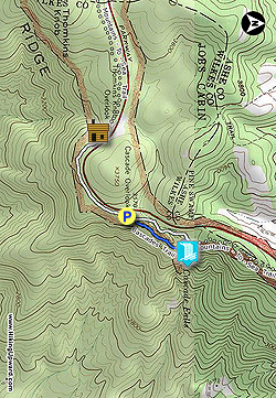
E.B. Jeffress Park is one of the smallest recreation areas (600 acres) managed by the Blue Ridge Parkway. Located just north of Deep Gap and U.S. 421, the park is home to two short trails to Tomkins Knob Overlook and Cascade Falls. Due to its proximity to the highway and Boone, NC, this is a very popular stop for travelers.

The main attraction is the waterfall but adding the interpretive trail to the reconstructed cabins will briefly bring you away from the crowds. Located in a grassy saddle below Thomkins Knob, the cabins offer a glimpse into 19th-century living. A loop trail combining the Cascades Trail and Mountains-to-Sea Trail brings you down to Cascade Falls, a high, cascading waterfall on Fall Creek that is nearly 150 feet high. Unfortunately, the official trail only leads down to the midpoint of the waterfall, but the view of this tall waterfall is still worth the short hike. This loop also includes twenty interpretive plaques providing a wealth of information about the ecological diversity you'll see on the trail.

  • Mile 0.0 – Park at the Cascades Trail parking area. Follow the Tomkins Knob Trail/Mountains-to-Sea Trail [440] (white blaze) for the optional 1-mile out-and-back to the Jesse Brown Cabin site.

  • Mile 0.5 – Turnaround point in a grassy meadow with the Jesse Brown Cabin and Cool Spring Baptist Church. The Cool Spring Baptist Church is located furthest from the road. A 3rd building, the spring house, is located beyond the Jesse Brown Cabin.

  • Mile 1.05 – Back at the parking lot, begin the Cascades Trail/MST near the bathrooms.

  • Mile 1.15 – Turn right on the Cascades Trail at a Y-junction with the MST.

  • Mile 1.4 – Lower crossing of Fall Creek using a wooden foot bridge. After the bridge, the trail splits. Turn right to the Cascade Falls Overlook. You will return to this spot.

  • Mile 1.5 – On the right side of the trail is the upper overlook for Cascade Falls. This overlook is at the precipice of the waterfall. Return to the trail and follow the stairs down to the lower overlook.

  • Mile 1.55 – The trail ends at the lower overlook for Cascade Falls. The long slide continues a fair distance downstream. Unfortunately, the trail does not continue to the base, and a rough scramble leaving the official trail is hazardous and would contribute to the severe erosion of the hillside.

  • Mile 1.7 – Upper crossing of Fall Creek on a second wooden foot bridge at a T-junction with the MST. The MST continues northeast from here.

  • Mile 2.0 – Hike ends at the Cascades Overlook parking lot.

By HikingUpward Contributor: Zach Robbins
Explore 28 trails near Stony Fork, NC

Know Before You Go

  • Cascade Falls Trail in E.B. Jeffress Park (Stony Fork, NC) is a popular, short 2-mile loop hike to a 150-foot cascading waterfall.
  • The hike offers an optional detour to the Jesse Brown Cabin site, providing a glimpse into 19th-century life with reconstructed cabins and a church.
  • The trail features two overlooks for Cascade Falls (upper and lower), with the trail ending at the lower overlook, and a warning against hazardous off-trail scrambling to the waterfall's base.
Interactive topographic map for Cascade Falls Hike located in Stony Fork, NC. Click the "View Map" button to load GPS coordinates and trail markers.
Get directions
Distance
2.0 mi
Difficulty
Easy
Type
Out-and-Back
Est. Time
1 hrs
Elev. Gain
267'
Rating
0.0
Added
March 22, 2025
Updated
April 06, 2025

Weather Forecast

Loading...
Total Change
261'
Ascent
267'
Descent
269'
Loading...

Download the GPX Data for Offline Use

Supporters get exclusive access to download trail routes to the MyHikes app for offline use. Stay prepared on your adventure, even without an internet connection! Become a Supporter today to unlock this feature and hike with confidence.

Download Cascade Falls Hike GPX Data to the MyHikes Mobile App

Features

Dogs
Waterfalls
Water Source

Points of interest

  1. Parking

    36.244868, -81.458216
  2. Main Trailhead

    36.244789, -81.458151

Safety information

For your own safety: plan ahead, let someone know where you'll be, and hike at your own risk.

Hazards

Snakes (Rattlesnakes, Copperheads, others)
Poison Ivy or Poison Oak

Availability

All seasons

Surface type

Dirt

Trip Reports (Reviews)

Your opinion matters! Be the first to rate this trail.

Ready to help fellow hikers? Add a trip report to share your experience and provide valuable insights for other hikers!

No community routes found. To add your own hike as a Community Route for this Trail guide, leave a Trip Report with an attached GPX file.

Popular categories

Scenic mountain view representing vista trails
Vista trails
Scenic gorge of cascades representing waterfall trails
Waterfall hikes
Rugged mountain terrain representing summit trails
Summit trails
Scenic mountain view representing dog-friendly trails
Dog-friendly
Scenic campsite with a view representing camping trails
Camping trails
Appalachian Trail logo representing A.T. hikes
A.T. hikes

You May Also Like

25 Best Day Hikes in North Carolina - Discover the top 25 best day hikes in North Carolina, from breathtaking waterfalls to mountain peaks. Explore hidden gems, scenic views, and trails suitable for all skill levels, perfect for your next outdoor adventure.
Explore

25 Best Day Hikes in North Carolina

Discover the top 25 best day hikes in North Carolina, from breathtaking waterfalls to mountain peaks. Explore hidden gems, scenic views, and trails suitable for all skill levels, perfect for your next outdoor adventure.

Read
Colorado's Million Dollar Highway - Plan a day's drive adventure along the iconic Million Dollar Highway in Colorado. Explore the best short trails, roadside stops, waterfalls, vistas, ghost towns, and hot springs within a ~6 hour road trip.
Explore

Colorado's Million Dollar Highway

Plan a day's drive adventure along the iconic Million Dollar Highway in Colorado. Explore the best short trails, roadside stops, waterfalls, vistas, ghost towns, and hot springs within a ~6 hour road trip.

Read
Glacier's Going-to-the-Sun Road - Discover the breathtaking beauty of Glacier National Park along the iconic Going-to-the-Sun Road. From stunning roadside stops to picturesque waterfalls and vistas, this engineering marvel offers endless opportunities for exploration.
Explore

Glacier's Going-to-the-Sun Road

Discover the breathtaking beauty of Glacier National Park along the iconic Going-to-the-Sun Road. From stunning roadside stops to picturesque waterfalls and vistas, this engineering marvel offers endless opportunities for exploration.

Read
🍪 We use cookies to learn about site usage and to serve map tiles. You may block cookies manually in the browser. By continuing you agree. Learn more