Loading...

WINTER SALE! 50% OFF Supporter Accounts — now through January 31st. Learn More.

Carbon River Road Trail

This hike along the Carbon River Road Trail at Mt. Rainier National Park near Ashford Washington is an easy 2.3-mile out-and-back trail that leads to the Old Mine Trail and beyond.

Carbon River rd used to be open to the public beyond this parking area, but from what I understand, it's now a trail due to road damage back in ~2007. The Carbon River rd trail is used to access various trails along this section of Mt. Rainier National Park like the Rain Forest Trail and Old Mine Trail.

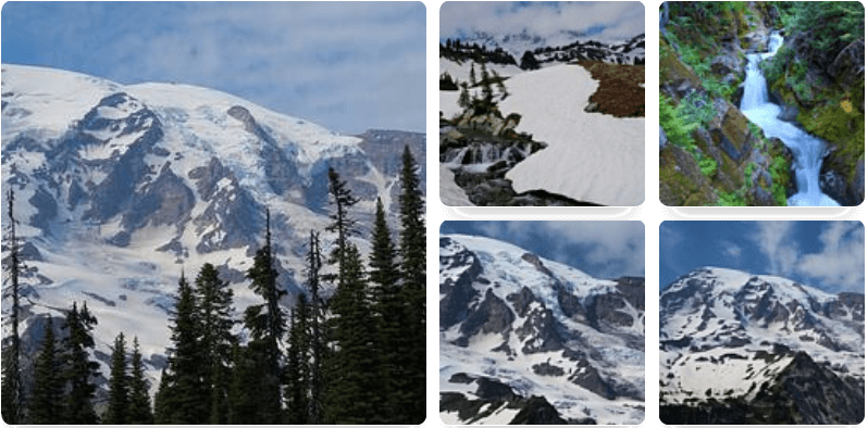
In late Winter and early Spring, you'll likely hear and see waterfalls through the trees - though, I could not find any trails that lead to them. The trail is littered with massive ancient trees, but I forgot to take any decent pictures with any reference alongside them. Regardless, they're definitely worth seeing. Also, plenty of deer to be found along this trail.

Fee
There's a National Park fee for parking, so make sure to pay before you hit the trail.

Parking
Hikers will find a large parking lot near the coordinates provided.
Explore 12 trails near Ashford, WA

Know Before You Go

  • Carbon River Road Trail is an easy 2.3-mile out-and-back trail near Ashford, WA, providing access to other Mt. Rainier National Park trails like the Old Mine Trail and Rain Forest Trail.
  • The trail follows a former road closed due to damage and features massive ancient trees, potential waterfall views in late winter/early spring, and frequent deer sightings.
  • A National Park fee is required for parking in the large lot at the trailhead.
Interactive topographic map for Carbon River Road Trail located in Ashford, WA. Click the "View Map" button to load GPS coordinates and trail markers.
Get directions
Distance
2.3 mi
Difficulty
Easy
Type
Out-and-Back
Est. Time
1.2 hrs
Elev. Gain
265'
Rating
0.0
Added
March 17, 2017
Updated
March 14, 2021

Weather Forecast

Loading...
Total Change
160'
Ascent
265'
Descent
272'
Loading...

Download the GPX Data for Offline Use

Supporters get exclusive access to download trail routes to the MyHikes app for offline use. Stay prepared on your adventure, even without an internet connection! Become a Supporter today to unlock this feature and hike with confidence.

Download Carbon River Road Trail GPX Data to the MyHikes Mobile App

Features

Waterfalls

Points of interest

  1. Parking

    46.994956, -121.915468
  2. Main Trailhead

    46.994855, -121.914777

Safety information

For your own safety: plan ahead, let someone know where you'll be, and hike at your own risk.

Availability

All seasons

Surface type

Dirt

Trip Reports (Reviews)

Your opinion matters! Be the first to rate this trail.

Ready to help fellow hikers? Add a trip report to share your experience and provide valuable insights for other hikers!

No community routes found. To add your own hike as a Community Route for this Trail guide, leave a Trip Report with an attached GPX file.

Popular categories

Scenic mountain view representing vista trails
Vista trails
Scenic gorge of cascades representing waterfall trails
Waterfall hikes
Rugged mountain terrain representing summit trails
Summit trails
Scenic mountain view representing dog-friendly trails
Dog-friendly
Scenic campsite with a view representing camping trails
Camping trails
Appalachian Trail logo representing A.T. hikes
A.T. hikes

You May Also Like

Glacier's Going-to-the-Sun Road - Discover the breathtaking beauty of Glacier National Park along the iconic Going-to-the-Sun Road. From stunning roadside stops to picturesque waterfalls and vistas, this engineering marvel offers endless opportunities for exploration.
Explore

Glacier's Going-to-the-Sun Road

Discover the breathtaking beauty of Glacier National Park along the iconic Going-to-the-Sun Road. From stunning roadside stops to picturesque waterfalls and vistas, this engineering marvel offers endless opportunities for exploration.

Read
Colorado's Million Dollar Highway - Plan a day's drive adventure along the iconic Million Dollar Highway in Colorado. Explore the best short trails, roadside stops, waterfalls, vistas, ghost towns, and hot springs within a ~6 hour road trip.
Explore

Colorado's Million Dollar Highway

Plan a day's drive adventure along the iconic Million Dollar Highway in Colorado. Explore the best short trails, roadside stops, waterfalls, vistas, ghost towns, and hot springs within a ~6 hour road trip.

Read
🍪 We use cookies to learn about site usage and to serve map tiles. You may block cookies manually in the browser. By continuing you agree. Learn more