The Campbell Run Falls Hike at Tioga State Forest near Wellsboro, Pennsylvania is a moderate 2-mile out-and-back off-trail trek that leads up Campbell Run creek to several very large waterfalls including Campbell Run Falls (25-feet tall), a tributary waterfall nicknamed Tributary Falls (20-feet tall), and a massive waterfall even further upstream which has two names, Amphitheater Falls, aka Cathedral Falls, which is approx. 50-feet tall.
Hike Description
This trek starts out along the Pine Creek Trail at the Tiadaghton Parking Area and follows the Pine Creek Trail south for about a quarter-mile before reaching Campbell Run. Hikers should note that this small section of Campbell Run creek is on private property; however, when I hiked this I ran into one of the property owners who said he did not mind if hikers went up the creek - stay off of his yard, etc - but hiking up the creek was fine. He also did not mind that this trip report was added to the interwebs.
Hiking up Campbell Run Creek
Hikers will note that they will want to stay in the creek until reaching just beyond the private property owner's yard. After hiking in the creek for about 600-feet, hikers are back onto public land and can hike in the woods, which is significantly easier especially if the leaves are not on the trees.
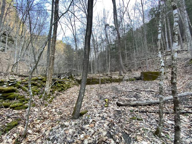
Staying on the right-hand side of the creek is an easy hike through the small trees and brush. Hikers will notice large cliff sides along the ravine that Campbell Run creek follows.
Abandoned Structures and Foundations
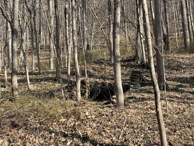
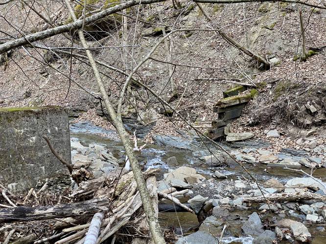
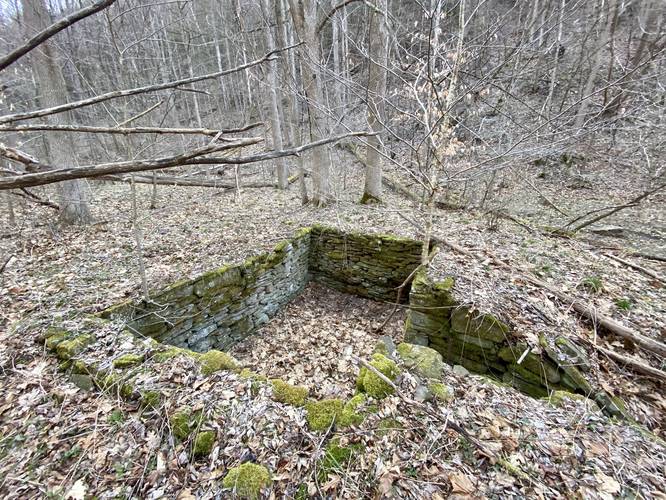
Along Campbell Run creek, not too far from where the private property ends, is a small foundation for what may have been an old house or camp. This section of the state forest was once part of a small logging village. Some of the buildings left standing today were either converted into camps or rebuilt. I don't know how many of the structures along the Pine Creek Trail at the Tiadaghton access area are original to the old logging town, if any. Hikers will also find what appears to be an old foundation for a dam as it stretches across the creek bed with old wooden planks still sticking out from the other side of the creek.
Reaching Tributary Falls
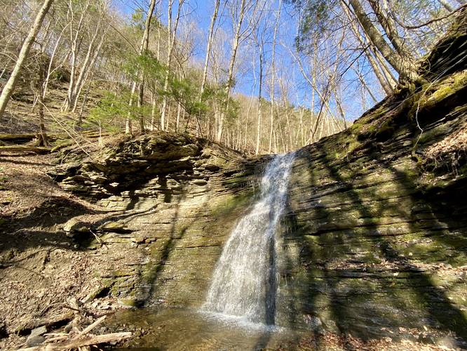
Hikers will want to continue hiking up the right-hand side of Campbell Run creek before reaching a creek junction with a tributary creek that feeds into Campbell Run. Here, hikers can continue hiking up Campbell Run for a couple-hundred more feet to reach an easy creek-crossing with larger rocks. Hikers will want to cross Campbell Run creek to reach the tributary creek. Hike up the tributary creek for no more than 0.1-miles to reach Tributary Falls, around mile 0.75, which is about 20-feet tall in total. This waterfall is pretty quiet as it spills down the rock face into the pool below, making this a nice serene place to take a break. Hikers may also notice more very large waterfalls spilling down this tributary creek behind Tributary Falls; however, the very steep terrain and hillside climb that leads around Tributary Falls is very dangerous.
Reaching Campbell Run Falls
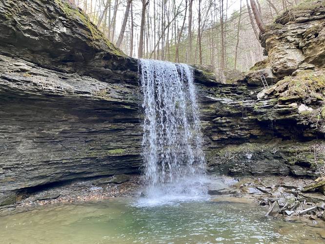
After visiting Tributary Falls, this track continues onward along Campbell Run creek up to Campbell Run Falls. If hikers stay on the left-side of the creek while hiking up stream, it's much easier to reach the waterfall. Around mile 1, hikers will reach the free-falling waterfall called Campbell Run Falls, which is about 25-feet tall. It spills over a rock ledge into a beautiful pool of water below, which appears to be about 2-feet deep.
Reaching Cathedral / Amphitheater Falls
After visiting Campbell Run Falls, well, this GPS track ends here; however, Amphitheater Falls (aka Cathedral Falls) - according to the private land owner - is not much more than 300 yards from Campbell Run Falls; however, hikers need to climb the ladder positioned on the right-hand side of Campbell Run Falls to continue hiking upstream. Please read the "Dangers - Must Read" section to understand why this track ends here; however, I may go back someday to finally get a view of the approximately 50-foot tall Amphitheater Falls (aka Cathedral Falls).
Parking
Hikers can park at the main parking lot along the Pine Creek Trail near the Tiadaghton Campground. Note that the road (Tiadaghton Hill Rd) that leads down to Tiadaghton Village is a skinny and rutted gravel road with some extreme elevation grade. There are several turnouts for cars to allow other vehicles to pass on the road; however, the road is located on an insanely-steep canyon mountainside, which makes the drive a bit terrifying at times. The road is not maintained during the Winter (late November - late April). Once the road meets the rail trail, drive down the rail trail (minding bikers and walkers) west to reach the parking lot.
Pets
Dogs are allowed if leashed. I left my small dog at home, but I think this hike is do-able for small dogs mid-Summer when the water level in the creek is lower. Please do not try to bring your dog to Amphitheater Falls for obvious reasons.
Camping and Backpacking
Technically backpackers can setup a small camp here by following the rules and regulations for backcountry / primitive / dispersed camping at Tioga State Forest, but there are no really good places to setup a campsite along this trek as it's mostly a bushwhack.
Wildflowers and Ramps
In the Spring, hikers may find wild ramps and rare wildflowers like Trillium growing in the forest along this trek.
Facilities
Restrooms can be found next to the parking area.
Private Property
As stated earlier, hikers will technically be on private property while hiking upstream in Campbell Run creek for about 600-feet or so before entering public lands. Upon my visit to these waterfalls, I ran into one of the property owners who said he does not mind if hikers access public lands via the creek. He also mentioned he bought his property ~40 years ago and nicknamed the largest waterfall, beyond the ladder climb, Cathedral Falls - hence the name referenced here. He also did not mind if I wrote about this hike and published it on the internet, which was super nice.
Dangers - Must Read
Reaching Cathedral Falls / Amphitheater Falls: Hikers should note that this GPS track does not reach Amphitheater Falls due to my fear of heights and what I felt was a large potential for getting hurt or even killed; however, maybe I'll come back to map it out once the terrain is less slippery. In order for hikers to reach Amphitheater Falls you must first reach Campbell Run Falls, hike across the creek and up a 20-foot tall hillside along a 12-inch wide sketchy path with a 20-foot drop-off to one side. Next hikers will need to climb a 5-foot tall ladder in addition to a 2-foot rock ledge above the ladder - with a rope next to it - along a wet and slippery waterfall ledge with a 25-foot drop-off just to the side. Granted, there are some ledges near the ladder, but trying this on a solo hike did not seem like a good idea at all. The alternative route is to hike up the very steep hillside, which on the surface seems less dangerous; however, the hillside's elevation grade, along with the slippery leaves, and lack of trees to catch your fall, would mean that if you did tumble down the hillside you would likely die after impact in Campbell Run below if not get critically injured and not be able to call for help or get out of the woods.
Slippery Creek Rocks: Hikers should bring trekking poles to allow them to traverse the creek easier. Also consider bringing waders so you don't have to rock-hop, to reduce the chance of slipping and getting hurt in the creek.
Off-trail Bushwhack: This hike does not follow any trail and is a total bushwhack. Hikers may find it difficult to navigate this terrain when the leaves are on the trees.
Rattlesnakes: While rare, the Timber Rattlesnake lives in this area and tends to come down to creeks to cool down or hunt between the end of April through the end of September. Watch your step and give any rattlesnake you see some space.
Winter Access
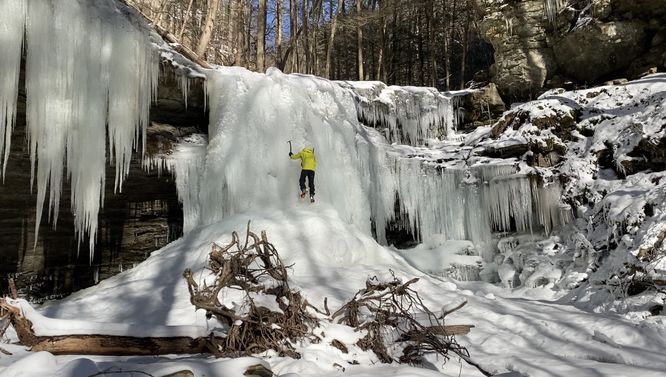
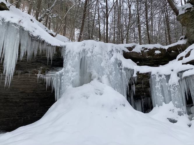
Reaching these waterfalls during the winter is possible with the proper gear (trekking poles, snow gaiters, crampons, gloves, and a hat) if the hiker begins at the road junctions of Putnam Rd and Tiadaghton Hill Rd in Delmar Township (Wellsboro), PA. Tiadaghton Hill Rd - from this junction leading down into the canyon - is not maintained during the winter. Please see the January 18, 2022 Trip Report about how to plan for this winter trek as the difficulty is strenuous, especially in snow.
Hike Description
This trek starts out along the Pine Creek Trail at the Tiadaghton Parking Area and follows the Pine Creek Trail south for about a quarter-mile before reaching Campbell Run. Hikers should note that this small section of Campbell Run creek is on private property; however, when I hiked this I ran into one of the property owners who said he did not mind if hikers went up the creek - stay off of his yard, etc - but hiking up the creek was fine. He also did not mind that this trip report was added to the interwebs.
Hiking up Campbell Run Creek
Hikers will note that they will want to stay in the creek until reaching just beyond the private property owner's yard. After hiking in the creek for about 600-feet, hikers are back onto public land and can hike in the woods, which is significantly easier especially if the leaves are not on the trees.
Staying on the right-hand side of the creek is an easy hike through the small trees and brush. Hikers will notice large cliff sides along the ravine that Campbell Run creek follows.
Abandoned Structures and Foundations
Along Campbell Run creek, not too far from where the private property ends, is a small foundation for what may have been an old house or camp. This section of the state forest was once part of a small logging village. Some of the buildings left standing today were either converted into camps or rebuilt. I don't know how many of the structures along the Pine Creek Trail at the Tiadaghton access area are original to the old logging town, if any. Hikers will also find what appears to be an old foundation for a dam as it stretches across the creek bed with old wooden planks still sticking out from the other side of the creek.
Reaching Tributary Falls
Hikers will want to continue hiking up the right-hand side of Campbell Run creek before reaching a creek junction with a tributary creek that feeds into Campbell Run. Here, hikers can continue hiking up Campbell Run for a couple-hundred more feet to reach an easy creek-crossing with larger rocks. Hikers will want to cross Campbell Run creek to reach the tributary creek. Hike up the tributary creek for no more than 0.1-miles to reach Tributary Falls, around mile 0.75, which is about 20-feet tall in total. This waterfall is pretty quiet as it spills down the rock face into the pool below, making this a nice serene place to take a break. Hikers may also notice more very large waterfalls spilling down this tributary creek behind Tributary Falls; however, the very steep terrain and hillside climb that leads around Tributary Falls is very dangerous.
Reaching Campbell Run Falls
After visiting Tributary Falls, this track continues onward along Campbell Run creek up to Campbell Run Falls. If hikers stay on the left-side of the creek while hiking up stream, it's much easier to reach the waterfall. Around mile 1, hikers will reach the free-falling waterfall called Campbell Run Falls, which is about 25-feet tall. It spills over a rock ledge into a beautiful pool of water below, which appears to be about 2-feet deep.
Reaching Cathedral / Amphitheater Falls
After visiting Campbell Run Falls, well, this GPS track ends here; however, Amphitheater Falls (aka Cathedral Falls) - according to the private land owner - is not much more than 300 yards from Campbell Run Falls; however, hikers need to climb the ladder positioned on the right-hand side of Campbell Run Falls to continue hiking upstream. Please read the "Dangers - Must Read" section to understand why this track ends here; however, I may go back someday to finally get a view of the approximately 50-foot tall Amphitheater Falls (aka Cathedral Falls).
Parking
Hikers can park at the main parking lot along the Pine Creek Trail near the Tiadaghton Campground. Note that the road (Tiadaghton Hill Rd) that leads down to Tiadaghton Village is a skinny and rutted gravel road with some extreme elevation grade. There are several turnouts for cars to allow other vehicles to pass on the road; however, the road is located on an insanely-steep canyon mountainside, which makes the drive a bit terrifying at times. The road is not maintained during the Winter (late November - late April). Once the road meets the rail trail, drive down the rail trail (minding bikers and walkers) west to reach the parking lot.
Pets
Dogs are allowed if leashed. I left my small dog at home, but I think this hike is do-able for small dogs mid-Summer when the water level in the creek is lower. Please do not try to bring your dog to Amphitheater Falls for obvious reasons.
Camping and Backpacking
Technically backpackers can setup a small camp here by following the rules and regulations for backcountry / primitive / dispersed camping at Tioga State Forest, but there are no really good places to setup a campsite along this trek as it's mostly a bushwhack.
Wildflowers and Ramps
In the Spring, hikers may find wild ramps and rare wildflowers like Trillium growing in the forest along this trek.
Facilities
Restrooms can be found next to the parking area.
Private Property
As stated earlier, hikers will technically be on private property while hiking upstream in Campbell Run creek for about 600-feet or so before entering public lands. Upon my visit to these waterfalls, I ran into one of the property owners who said he does not mind if hikers access public lands via the creek. He also mentioned he bought his property ~40 years ago and nicknamed the largest waterfall, beyond the ladder climb, Cathedral Falls - hence the name referenced here. He also did not mind if I wrote about this hike and published it on the internet, which was super nice.
Dangers - Must Read
Reaching Cathedral Falls / Amphitheater Falls: Hikers should note that this GPS track does not reach Amphitheater Falls due to my fear of heights and what I felt was a large potential for getting hurt or even killed; however, maybe I'll come back to map it out once the terrain is less slippery. In order for hikers to reach Amphitheater Falls you must first reach Campbell Run Falls, hike across the creek and up a 20-foot tall hillside along a 12-inch wide sketchy path with a 20-foot drop-off to one side. Next hikers will need to climb a 5-foot tall ladder in addition to a 2-foot rock ledge above the ladder - with a rope next to it - along a wet and slippery waterfall ledge with a 25-foot drop-off just to the side. Granted, there are some ledges near the ladder, but trying this on a solo hike did not seem like a good idea at all. The alternative route is to hike up the very steep hillside, which on the surface seems less dangerous; however, the hillside's elevation grade, along with the slippery leaves, and lack of trees to catch your fall, would mean that if you did tumble down the hillside you would likely die after impact in Campbell Run below if not get critically injured and not be able to call for help or get out of the woods.
Slippery Creek Rocks: Hikers should bring trekking poles to allow them to traverse the creek easier. Also consider bringing waders so you don't have to rock-hop, to reduce the chance of slipping and getting hurt in the creek.
Off-trail Bushwhack: This hike does not follow any trail and is a total bushwhack. Hikers may find it difficult to navigate this terrain when the leaves are on the trees.
Rattlesnakes: While rare, the Timber Rattlesnake lives in this area and tends to come down to creeks to cool down or hunt between the end of April through the end of September. Watch your step and give any rattlesnake you see some space.
Winter Access
Reaching these waterfalls during the winter is possible with the proper gear (trekking poles, snow gaiters, crampons, gloves, and a hat) if the hiker begins at the road junctions of Putnam Rd and Tiadaghton Hill Rd in Delmar Township (Wellsboro), PA. Tiadaghton Hill Rd - from this junction leading down into the canyon - is not maintained during the winter. Please see the January 18, 2022 Trip Report about how to plan for this winter trek as the difficulty is strenuous, especially in snow.