Amphitheater Falls at Tioga State Forest near Wellsboro, Pennsylvania is a moderate 2.1-mile out-and-back hike that leads to the 50-foot waterfall, Amphitheater Falls, and features a stop at the 25-foot tall Campbell Run Falls and the 20-foot tall Tributary Falls.
This is an off-trail bushwhack meant for the experienced hiker because of a sketchy hillside scramble that includes an additional 6-foot tall rock scramble with a ladder that sits next to the 25-foot plunge of Campbell Run Falls in order to reach Amphitheater Falls.
Hike Description
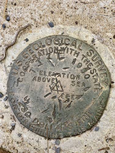
This hike begins at the main parking lot for the Tiadaghton Campground which is just off-trail from the Pine Creek Trail in Tiadaghton Village and follows the Pine Creek Trail east back into the village. At Campbell Run creek, hikers will begin their creek walk upstream. Note that both sides of the creek are privately-owned and while there's a "grandfathered" overgrown path behind the weathered and unused property on the left-hand side, it's best to hike the creek so that you do not trespass on either side. As the hiker enters the creek is a USGS Survey marker as well located on the concrete block that the bridge is attached to, which is an interesting find for this location. Also note that I (Admin) have hiked here during the Spring and Winter, in the creek when the water is higher, but that is difficult and can be dangerous, so it might be best to skirt around the vacant property to reach the overgrown path if the water level is higher.
Creek Hike, Old Splash Dam, Syd's Gully - Mile 0.28 to 0.5
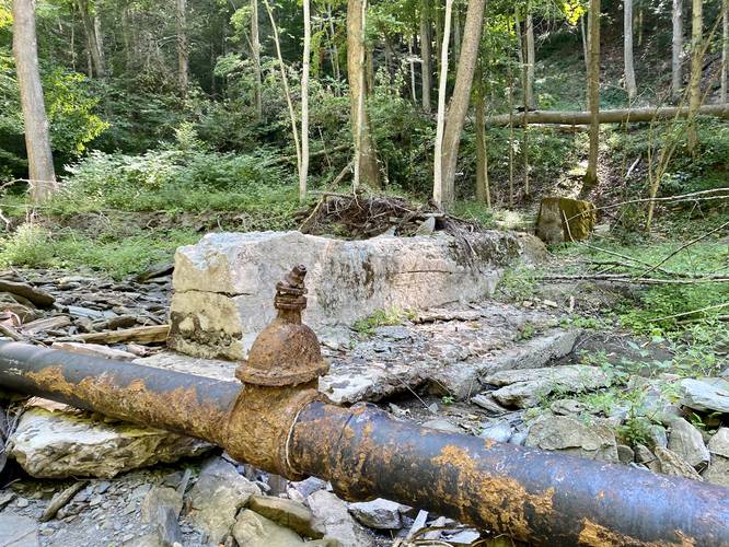
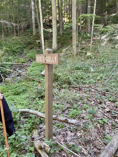
From miles 0.28 to mile 0.5, there's not much to see along the way. If you arrive when the creek is flowing strong, you won't want to be hiking in or near the creek for long. The overgrown path, that most hikers take, follows the creek on its western bank; however, this track follows the creek in its entirety as a mid-Summer dry creek hike. Along the way, hikers will notice a black metal pipe that leads down the creek, which is about 1.5-feet in diameter. Around mile 0.5, hikers will reach an old dam - likely an old splash dam, which were used to drive logs down creeks in order to send them to mills further downstream like in Williamsport, PA (circa early 1900's). In the middle of the creek is a piping fixture that's shaped like a cap - from here, the pipe leads behind where the old dam once stood and then splits into two or three open pipe ends. It seems as if this pipe was used to redirect water down Campbell Run, despite the dam holding the water back - potentially to fill water tanks for the steam train engines that once ran along Pine Creek or to provide water for the towns folk of Tiadaghton Village. Just uphill from this old splash dam is a brown forestry sign labeled "Syd's Gully" - this sign, according to Jim Emily (retired from Tioga State Forest), was from an incident where Jack Sherwood's (a district Forester at the time) friend, Syd, got lost or fell in this gully, so the sign was put up as a joke or to poke fun at Syd.
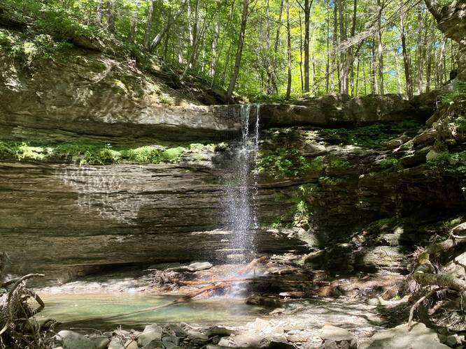
Campbell Run Falls - Mile 0.85
Around mile 0.85, hikers will reach Campbell Run Falls which is a free-falling waterfall that cascades over the bedrock approximately 25 to 30-feet above the pool below. Even during the Summer, the pool below Campbell Run Falls is fairly deep.
Reaching Amphitheater Falls - Scramble and Ladder Climb
The safest way to reach Amphitheater Falls, from Campbell Run Falls, is to hike the hillside scramble to the right-hand side of Campbell Run Falls, which leads to a small metal ladder and rock scramble. As of August 2022 (and earlier), this metal ladder and a tied-off rope has sat on the Campbell Run Falls rock ledge to provide a way to reach Amphitheater Falls, but it's not for the faint of heart or inexperienced hikers. The scramble that leads uphill is a bit steep and sketchy. Additionally, the path that leads to the metal ladder is skinny and sits next to a steep drop. The last section - the ladder and rock scramble - can be a bit challenging if you're not used to scrambles. The ladder leads up ~3-feet before it ends, then the hiker must scramble the remaining 2-feet on the rock ledge while pulling themselves up either on rock or by using the rope as a handhold. Once at the top of Campbell Run Falls, reaching Amphitheater Falls from here is very easy, assuming the water level is not too high. Hikers will walk the remaining 0.25-miles up the creek following solid bedrock before reaching the 50-foot Amphitheater Falls.
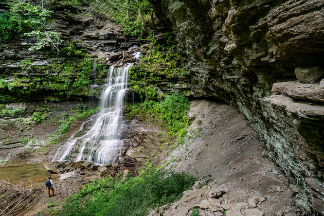
Amphitheater Falls - Mile 1
At mile 1, hikers will reach the 50-foot tall Amphitheater Falls as it cascades down a wide "skirt" of red bedrock below, rock ledges above, all while surrounded by small ferns growing on the cliffs. Amphitheater Falls gets its name from the rock gorge that the waterfall sits in. Hikers may notice the rock ledges above them stick out and over the creek slightly on the left-hand side, while the right-hand side of the gorge has a sheer 50-foot (or more) vertical rock wall that extends far beyond the waterfall area. These two rock walls encompass the gorge, creating an Amphitheater of sorts. When I first visited this creek in Spring 2021, I met the owner of the private cabin in Tiadaghton Village, who'd purchased the property over 40-years prior. When he found this waterfall, he nicknamed it Cathedral Falls, which is another fitting name for this cascade.
Rock Scramble Down to Campbell Run Falls
After visiting Amphitheater Falls, hikers will be forced back down the rock scramble at Campbell Run Falls. The easiest way down is to get one or two feet on the metal ladder - facing outward toward the waterfall, and then simply shift your body weight and jump left down the remaining 1.5-feet to the rock ledge next to the waterfall. It's difficult going down since you usually can't see your feet very well.
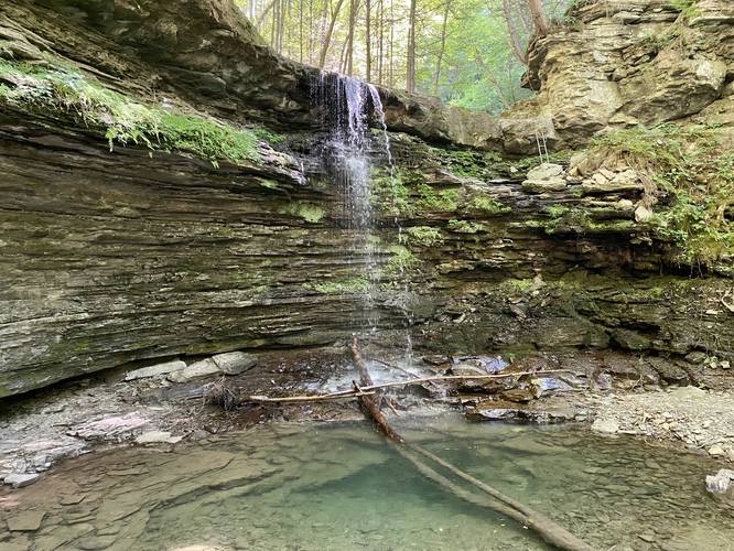
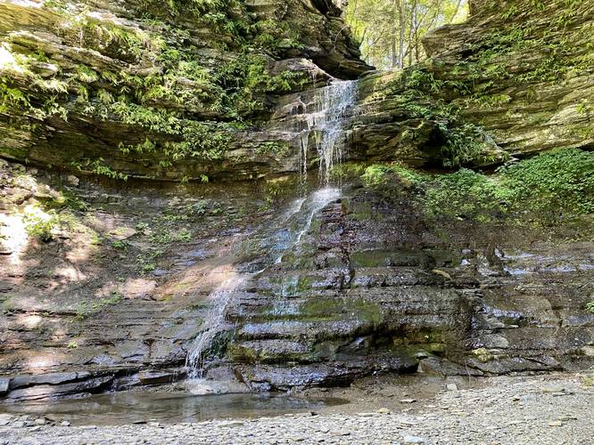
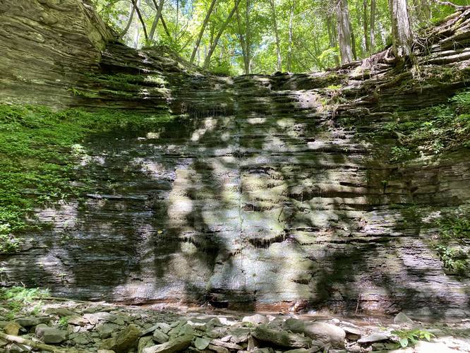
Hiking Out & Tributary Falls - Mile 1.5
After reaching Campbell Run Falls, hikers can choose to hike down the loosely-defined footpath or follow the creek if it's dry enough. At mile 1.4, there's a turn in the footpath, or if in the creek look for the tributary creek that feeds in, and head upstream here. There's another 20-foot waterfall that flows pretty well during the Spring and Winter at mile 1.5; however, in the Summer it's mostly a trickle. I've nicknamed this waterfall Tributary Falls. When it does flow, the cascading water is almost silent as it washes down the mossy rock face of this ledge. After visiting Tributary Falls, the hike is usually easy heading out - assuming you don't have to ford the creek very much to reach the Pine Creek Trail.
Warnings
Bushwhack & Creek Walk: This hike is mostly a bushwhack with some creek walking involved. Both properties on the left and right-hand sides of Campbell Run creek are technically privately-owned; however, the creek is public. To avoid trespassing, its best to stay in the public land for as long as it's safe. To do so requires some creek hiking. Additionally, if the water is high (Spring or Winter), it's best to avoid being in the creek for too long to avoid injury or drowning. There's a loosely-defined footpath on the west side of the creek and a bushwhack on the right-hand side. Either way, to traverse this area while the water is high can be difficult and dangerous.
Scrambles: To reach Amphitheater Falls, hikers will have to scramble up a sketchy hillside which leads to a sketchy rock scramble with a ladder, all while sitting next to a 25-foot drop. Do not attempt to reach Amphitheater Falls if you do not feel comfortable.
Landslides: This area shows obvious signs of landslides while walking through this gorge along with entire fallen trees that have come crashing down into the gorge from hundreds of feet above. During the Spring, the snowmelt and rain loosen the soil in these mountains, causing higher risk for landslides in the canyon. This area is no exception and thus washouts, flash floods, and landslides can all change the topography of this area year after year.
Timber Rattlesnakes: The Timber Rattlesnake calls this area its home and between the months of late April to early October, you may find them in the creek or in the woods. Watch your step and always be on the lookout for rattlers.
Parking
Hikers can park at the main parking lot along the Pine Creek Trail near the Tiadaghton Campground. Note that the road (Tiadaghton Hill Rd) that leads down to Tiadaghton Village is a skinny and rutted gravel road with some extreme elevation grade. There are several turnouts for cars to allow other vehicles to pass on the road; however, the road is located on an insanely-steep canyon mountainside, which makes the drive a bit terrifying at times. The road is not maintained during the Winter (late November - late April). Once the road meets the rail trail, drive down the rail trail (minding bikers and walkers) west to reach the parking lot.
Camping & Backpacking
There are no defined campsites along this trail, but Tioga State Forest does permit primitive / backcountry / dispersed camping. Please follow all state forest rules if camping.
Pets
Dogs are allowed if leashed and their waste should be carried out by the hiker. Due to the steep terrain (above and around Campbell Run Falls), it's best to leave your dog below Campbell Run Falls if you wish to venture to Amphitheater Falls since it may put your dog in a precarious situation on the steep hillside above Campbell Run Falls.
This is an off-trail bushwhack meant for the experienced hiker because of a sketchy hillside scramble that includes an additional 6-foot tall rock scramble with a ladder that sits next to the 25-foot plunge of Campbell Run Falls in order to reach Amphitheater Falls.
Hike Description
This hike begins at the main parking lot for the Tiadaghton Campground which is just off-trail from the Pine Creek Trail in Tiadaghton Village and follows the Pine Creek Trail east back into the village. At Campbell Run creek, hikers will begin their creek walk upstream. Note that both sides of the creek are privately-owned and while there's a "grandfathered" overgrown path behind the weathered and unused property on the left-hand side, it's best to hike the creek so that you do not trespass on either side. As the hiker enters the creek is a USGS Survey marker as well located on the concrete block that the bridge is attached to, which is an interesting find for this location. Also note that I (Admin) have hiked here during the Spring and Winter, in the creek when the water is higher, but that is difficult and can be dangerous, so it might be best to skirt around the vacant property to reach the overgrown path if the water level is higher.
Creek Hike, Old Splash Dam, Syd's Gully - Mile 0.28 to 0.5
From miles 0.28 to mile 0.5, there's not much to see along the way. If you arrive when the creek is flowing strong, you won't want to be hiking in or near the creek for long. The overgrown path, that most hikers take, follows the creek on its western bank; however, this track follows the creek in its entirety as a mid-Summer dry creek hike. Along the way, hikers will notice a black metal pipe that leads down the creek, which is about 1.5-feet in diameter. Around mile 0.5, hikers will reach an old dam - likely an old splash dam, which were used to drive logs down creeks in order to send them to mills further downstream like in Williamsport, PA (circa early 1900's). In the middle of the creek is a piping fixture that's shaped like a cap - from here, the pipe leads behind where the old dam once stood and then splits into two or three open pipe ends. It seems as if this pipe was used to redirect water down Campbell Run, despite the dam holding the water back - potentially to fill water tanks for the steam train engines that once ran along Pine Creek or to provide water for the towns folk of Tiadaghton Village. Just uphill from this old splash dam is a brown forestry sign labeled "Syd's Gully" - this sign, according to Jim Emily (retired from Tioga State Forest), was from an incident where Jack Sherwood's (a district Forester at the time) friend, Syd, got lost or fell in this gully, so the sign was put up as a joke or to poke fun at Syd.
Campbell Run Falls - Mile 0.85
Around mile 0.85, hikers will reach Campbell Run Falls which is a free-falling waterfall that cascades over the bedrock approximately 25 to 30-feet above the pool below. Even during the Summer, the pool below Campbell Run Falls is fairly deep.
Reaching Amphitheater Falls - Scramble and Ladder Climb
The safest way to reach Amphitheater Falls, from Campbell Run Falls, is to hike the hillside scramble to the right-hand side of Campbell Run Falls, which leads to a small metal ladder and rock scramble. As of August 2022 (and earlier), this metal ladder and a tied-off rope has sat on the Campbell Run Falls rock ledge to provide a way to reach Amphitheater Falls, but it's not for the faint of heart or inexperienced hikers. The scramble that leads uphill is a bit steep and sketchy. Additionally, the path that leads to the metal ladder is skinny and sits next to a steep drop. The last section - the ladder and rock scramble - can be a bit challenging if you're not used to scrambles. The ladder leads up ~3-feet before it ends, then the hiker must scramble the remaining 2-feet on the rock ledge while pulling themselves up either on rock or by using the rope as a handhold. Once at the top of Campbell Run Falls, reaching Amphitheater Falls from here is very easy, assuming the water level is not too high. Hikers will walk the remaining 0.25-miles up the creek following solid bedrock before reaching the 50-foot Amphitheater Falls.
Amphitheater Falls - Mile 1
At mile 1, hikers will reach the 50-foot tall Amphitheater Falls as it cascades down a wide "skirt" of red bedrock below, rock ledges above, all while surrounded by small ferns growing on the cliffs. Amphitheater Falls gets its name from the rock gorge that the waterfall sits in. Hikers may notice the rock ledges above them stick out and over the creek slightly on the left-hand side, while the right-hand side of the gorge has a sheer 50-foot (or more) vertical rock wall that extends far beyond the waterfall area. These two rock walls encompass the gorge, creating an Amphitheater of sorts. When I first visited this creek in Spring 2021, I met the owner of the private cabin in Tiadaghton Village, who'd purchased the property over 40-years prior. When he found this waterfall, he nicknamed it Cathedral Falls, which is another fitting name for this cascade.
Rock Scramble Down to Campbell Run Falls
After visiting Amphitheater Falls, hikers will be forced back down the rock scramble at Campbell Run Falls. The easiest way down is to get one or two feet on the metal ladder - facing outward toward the waterfall, and then simply shift your body weight and jump left down the remaining 1.5-feet to the rock ledge next to the waterfall. It's difficult going down since you usually can't see your feet very well.
Hiking Out & Tributary Falls - Mile 1.5
After reaching Campbell Run Falls, hikers can choose to hike down the loosely-defined footpath or follow the creek if it's dry enough. At mile 1.4, there's a turn in the footpath, or if in the creek look for the tributary creek that feeds in, and head upstream here. There's another 20-foot waterfall that flows pretty well during the Spring and Winter at mile 1.5; however, in the Summer it's mostly a trickle. I've nicknamed this waterfall Tributary Falls. When it does flow, the cascading water is almost silent as it washes down the mossy rock face of this ledge. After visiting Tributary Falls, the hike is usually easy heading out - assuming you don't have to ford the creek very much to reach the Pine Creek Trail.
Warnings
Bushwhack & Creek Walk: This hike is mostly a bushwhack with some creek walking involved. Both properties on the left and right-hand sides of Campbell Run creek are technically privately-owned; however, the creek is public. To avoid trespassing, its best to stay in the public land for as long as it's safe. To do so requires some creek hiking. Additionally, if the water is high (Spring or Winter), it's best to avoid being in the creek for too long to avoid injury or drowning. There's a loosely-defined footpath on the west side of the creek and a bushwhack on the right-hand side. Either way, to traverse this area while the water is high can be difficult and dangerous.
Scrambles: To reach Amphitheater Falls, hikers will have to scramble up a sketchy hillside which leads to a sketchy rock scramble with a ladder, all while sitting next to a 25-foot drop. Do not attempt to reach Amphitheater Falls if you do not feel comfortable.
Landslides: This area shows obvious signs of landslides while walking through this gorge along with entire fallen trees that have come crashing down into the gorge from hundreds of feet above. During the Spring, the snowmelt and rain loosen the soil in these mountains, causing higher risk for landslides in the canyon. This area is no exception and thus washouts, flash floods, and landslides can all change the topography of this area year after year.
Timber Rattlesnakes: The Timber Rattlesnake calls this area its home and between the months of late April to early October, you may find them in the creek or in the woods. Watch your step and always be on the lookout for rattlers.
Parking
Hikers can park at the main parking lot along the Pine Creek Trail near the Tiadaghton Campground. Note that the road (Tiadaghton Hill Rd) that leads down to Tiadaghton Village is a skinny and rutted gravel road with some extreme elevation grade. There are several turnouts for cars to allow other vehicles to pass on the road; however, the road is located on an insanely-steep canyon mountainside, which makes the drive a bit terrifying at times. The road is not maintained during the Winter (late November - late April). Once the road meets the rail trail, drive down the rail trail (minding bikers and walkers) west to reach the parking lot.
Camping & Backpacking
There are no defined campsites along this trail, but Tioga State Forest does permit primitive / backcountry / dispersed camping. Please follow all state forest rules if camping.
Pets
Dogs are allowed if leashed and their waste should be carried out by the hiker. Due to the steep terrain (above and around Campbell Run Falls), it's best to leave your dog below Campbell Run Falls if you wish to venture to Amphitheater Falls since it may put your dog in a precarious situation on the steep hillside above Campbell Run Falls.