The Box Canyon Falls Trail at Box Cañon Falls Park in Ouray, Colorado is an easy 0.2-mile out-and-back trail that leads to the 285-foot tall waterfall nestled within Box Canyon known as Box Canyon Falls.
Walk to the Falls
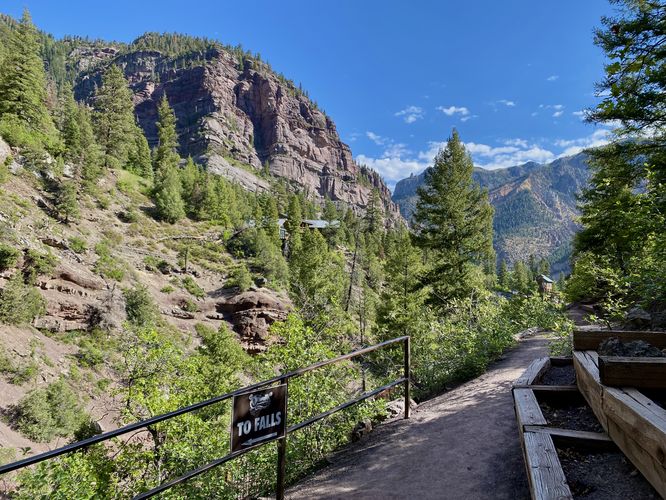
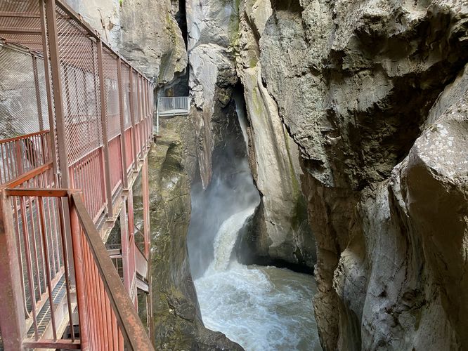
This trail begins at the main parking lot and trail entrance for the Box Cañon Falls Park and heads-in along the mostly-flat dirt trail following signs labeled "To Falls". The trail passes under Ouray's mountain cliffs - one high above boasts the "Box Cañon" sign, which was built in the early 1900s. The trail eventually leads downhill and reaches a junction with the Box Canyon Nature Trail, before it takes a left-hand turn to follow a cliff line. The trail begins to follow the cliffs as it wraps its way into Box Canyon. The path switches to follow a suspended metal grate walkway which leads deeper into the canyon. Not far after following the trail around the bend into the canyon, Box Canyon Falls appears. The waterfall flows heaviest during the Spring, which can make visiting the end of the trail a bit tricky as to not get too wet. The best view of Box Canyon Falls comes into view approximately 100-feet downstream from the cascade. The trail continues onward to reach a cave in the canyon where the waterfall plunges down into; however, I stayed back 50-feet further, at the end of this route, as the metal grate became extremely slippery and the waterfall's view became worse as I approached the plumes of mist in the air. The trail also includes a staircase you can descend, if you wish, to view the waterfall from closer to its base. This experience is pretty crazy overall especially if you aren't used to the forceful nature of very tall flume-like waterfalls, not to mention the deafening roar it creates. Box Canyon Falls, if visiting the Ouray area, is well worth the fee to explore it.
Other Trails at the Park
Don't forget to explore the Box Canyon Nature Trail and or the High Bridge Trail before you leave the park.
Parking
Hikers will find a large parking lot at the coordinates provided, located at Box Canyon Falls Park in Ouray. The lot is large enough to fit a couple dozen vehicles as of June 2024.
Restrooms
There are restrooms at the park, located north of the main parking lot.
Hours
You can find more information about the park's hours on their website. As of June 2024, the park is closed during the Winter (November - March) each year. Otherwise the park is open from 9AM - 5PM each day. Memorial Day through Labor Day the park is open from 8AM - 8PM each day.
Fees
There's a minimal fee to enter the park, per person. As of June 2024, adults are $7/person and children are $5/person. You can read more about their fees on the park's website.
Walk to the Falls
This trail begins at the main parking lot and trail entrance for the Box Cañon Falls Park and heads-in along the mostly-flat dirt trail following signs labeled "To Falls". The trail passes under Ouray's mountain cliffs - one high above boasts the "Box Cañon" sign, which was built in the early 1900s. The trail eventually leads downhill and reaches a junction with the Box Canyon Nature Trail, before it takes a left-hand turn to follow a cliff line. The trail begins to follow the cliffs as it wraps its way into Box Canyon. The path switches to follow a suspended metal grate walkway which leads deeper into the canyon. Not far after following the trail around the bend into the canyon, Box Canyon Falls appears. The waterfall flows heaviest during the Spring, which can make visiting the end of the trail a bit tricky as to not get too wet. The best view of Box Canyon Falls comes into view approximately 100-feet downstream from the cascade. The trail continues onward to reach a cave in the canyon where the waterfall plunges down into; however, I stayed back 50-feet further, at the end of this route, as the metal grate became extremely slippery and the waterfall's view became worse as I approached the plumes of mist in the air. The trail also includes a staircase you can descend, if you wish, to view the waterfall from closer to its base. This experience is pretty crazy overall especially if you aren't used to the forceful nature of very tall flume-like waterfalls, not to mention the deafening roar it creates. Box Canyon Falls, if visiting the Ouray area, is well worth the fee to explore it.
Other Trails at the Park
Don't forget to explore the Box Canyon Nature Trail and or the High Bridge Trail before you leave the park.
Parking
Hikers will find a large parking lot at the coordinates provided, located at Box Canyon Falls Park in Ouray. The lot is large enough to fit a couple dozen vehicles as of June 2024.
Restrooms
There are restrooms at the park, located north of the main parking lot.
Hours
You can find more information about the park's hours on their website. As of June 2024, the park is closed during the Winter (November - March) each year. Otherwise the park is open from 9AM - 5PM each day. Memorial Day through Labor Day the park is open from 8AM - 8PM each day.
Fees
There's a minimal fee to enter the park, per person. As of June 2024, adults are $7/person and children are $5/person. You can read more about their fees on the park's website.