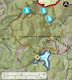
Julian Price Memorial Park is one of the most popular spots along the Blue Ridge Parkway due to its large campgrounds, picnic areas, easy trails, and a scenic roadside lake. Due to its proximity to Boone and Grandfather Mountain, you will be amongst many other hikers on these trails. There are 3 easy loop trails within the park. Two of them can be combined to create a wonderfully easy 8-mile figure eight loop taking you along Price Lake and the rocky Boone Fork. This hike starts at the Price Lake Overlook and takes the Boone Fork Trail counterclockwise, following Bee Tree Creek down to Boone Fork.
You will then follow the rocky, scenic Boone Fork for 3+ miles back to the parkway before taking a very easy loop around Price Lake. The highlights of the lake trail are its multiple views from different angles, and an awesome view of Grandfather Mountain dominating the skyline. Although this hike starts with the Boone Fork Trail, it is advised to hike Price Lake first to see the views earlier in the day. In the afternoon the sun sits directly over Grandfather Mountain. Plus towards the end of the Boone Fork Trail there are many great pools for swimming.
From the U.S 321 exit on the Blue Ridge Parkway in Blowing Rock, head south for 4.8 miles to Julian Price Memorial Park. This section is often quite crowded and traffic is slow. Price Lake will appear on the left and the obvious parking area for the Price Lake Overlook is directly after a bridge. An alternative start point is the Price Lake picnic area 0.3 miles before Price Lake. The Boone Fork Trail begins here, however on the weekends this picnic area can be slammed with people and difficult to park at.
Note: This mileage description contains an extra 0.3 miles of backtracking only to discover the unmarked side trail off Bee Tree Creek leads to private property.
- Mile 0.0 – Head towards the south end of the parking lot and start the paved Price Lake Trail heading towards campgrounds
- Mile 0.2 – Cross over campground roads
- Mile 0.3 – Take a right at comfort station (bathrooms) and cross over Blue Ridge Parkway towards the campground entrance station
- Mile 0.4 – Take a left onto the Boone Fork Trail (orange diamond blaze) passing through a series of campgrounds
- Mile 0.7 – Leave campgrounds and head into mature rhododendron forest
- Mile 0.8 – Intersection with Tanawha Trail (white blaze), stay right
- Mile 1.0 – Intersection with Mountains-to-Sea Trail (MST) (white circle blaze) and Tanawha Trail, stay right and pass through a field with view of Calloway Peak
- Mile 1.2 – A spur trail heads left to Tanawha Trail, stay right and descend into forest
- Mile 1.3 – A second spur trail heads left to the Tanawha Trail, stay right
- Mile 1.7 – First crossing over a small tributary of Bee Tree Creek on a bridge. You will cross this tributary and Bee Tree Creek 12 times in the next 0.7 miles
- Mile 1.8 – 2nd and 3rd rock hop crossings over tributary
- Mile 1.9 – 4th bridge crossing over tributary followed by 5th rock crossing over Bee Tree Creek
- Mile 2.1 – 6th and 7th rock crossings over Bee Tree Creek
- Mile 2.2 – 8th bridge crossing over Bee Tree Creek
- Mile 2.3 – 9th-11th rock crossings over Bee Tree Creek in quick succession. At the 11th crossing the rocks are covered in a nice layer of moss
- Mile 2.4 – Final 12th crossing over Bee Tree Creek with a small cascade above. An unmarked side trail on left leads to private property boundary in 300 feet
- Mile 2.9 – Side trail down to a section of Boone Fork with a nice cascade, a large pool, then another cascade
- Mile 3.1 – Rock crossing over unnamed tributary
- Mile 3.2 – A very steep side trail leads to the bottom of a rocky section along Boone Fork. Skip this slick descent and head up the trail a few hundred feet
- Mile 3.3 – Easy side trail to the middle of cascades on Boone Fork
- Mile 3.5 – Another nice spot along Boone Fork with multiple inviting flat rocks and pools. The trail takes a sharp turn away from the river
- Mile 3.6 – A ladder descends through a large rock chute
- Mile 3.8 – Side trail to Hebron Colony Falls. This trail is a steep 0.1 mile descent to the river
-
Mile 3.9 – Reach Boone Fork at the base of a stretch of massive boulders in the river. The rocks are so large and plentiful here you can barely see the water flowing below them.
Note: Hebron Colony Falls is not visible from the end of the trail. You will have to go bouldering up the river to the waterfall as there are no scramble trails along the river banks. The bouldering is relatively safe and requires little climbing. However this would be very dangerous when the rocks are wet.
- Mile 4.0 – Reach the base of Hebron Colony Falls, a modest 20 foot waterfall hidden amongst the massive boulder field. Carefully scramble back down towards the trail.
- Mile 4.2 – Return to Boone Fork Trail and continue along the river
- Mile 4.5 – After passing by a calm section of the river there is a nice section of small cascades
- Mile 4.6 – Intersection with MST (white circle blaze), stay straight while the MST crosses the river
- Mile 4.8 – Boone Fork surprisingly becomes mellow <0286> at this high elevation as you pass through wildflower meadows. This section for the next 0.8 miles used to be an ancient lake and is now a mountain bog
- Mile 5.7 – Intersection with the Price Park picnic area, stay right to complete the loop heading back towards the campgrounds
- Mile 6.2 – Pass by the campground entrance station and head towards the original crossing at the Blue Ridge Parkway
- Mile 6.4 – After crossing over Blue Ridge Parkway, head towards comfort station and go right on the Price Lake Trail. You will pass by more campgrounds and go through the amphitheater. The trail through this heavily used section is paved.
- Mile 6.6 – The trail follows the sidewalk along the Lakeview Overlook parking area before passing by the kayak rental station. After the small marina the trail will leave the built up parkway amenities and head back in the forest
- Mile 7.0 – Bridge crossing over Boone Fork
- Mile 7.1 – A wooden platform in the lake offers great views
- Mile 7.3 – The trail heads right away from the lake and dives into thick rhododendron, an unmarked side trail stays beside the lake but does not connect
- Mile 7.7 – Come to a boggy area and cross over Laurel Creek on a boardwalk. The trail soon straddles the lakeshore again
- Mile 8.1 – Two excellent viewing areas of the lake looking southwest, Grandfather Mountain dominates the skyline
- Mile 8.4 – The hike ends at the Price Lake Overlook