Loading...

๐ŸŽ‰ Enjoy a Free 7-Day Supporter Trial and Unlock Exclusive Perks โ€” No Credit Card Required. Learn more.

Big Bald Hike

Directions
Map
Pictures
Send to App
Distance:
12.9 Miles / 20.8 km
Type:
Out-and-Back
Difficulty:
Hard
Time to Hike:
6 hours, ~27 minutes
Features:
Appalachian Trail hike
Surface Type:
Dirt
Park:
Pisgah National Forest
Town:
Mars Hill, North Carolina
Directions:
35.952378, -82.560802
Added:
March 13, 2025
Updated:
April 05, 2025
Copy Trail Link Hiking this trail? Send a friend or family member a link to this trail guide for your own safety. Hike at your own risk (disclaimer)
Loading...
Loading...
1,782'

Total Change
3,628'

Ascent
3,626'

Descent

Download the Trail Route for Offline Use

Supporters get exclusive access to download trail routes to the MyHikes app for offline use. Stay prepared on your adventure, even without an internet connection! Become a Supporter today to unlock this feature and hike with confidence.

Send to App

Big Bald Hike

The long trek to Big Bald is a classic Appalachian Trail hike in the Southeast. (Unless you happen to be staying at the Wolf Laurel Resort, then you can take a much shorter hike to the summit.) Although long at 13 miles, this hike feels much easier than most because it is well-maintained and the grades are never too steep. It is also conveniently located off I-26, which means it is can be hiked all winter while other trails in the region may be inaccessible.

The hike starts at Sams Gap on the NC/TN border and gradually ascends through maple and oak forest for 6.5 miles to the expansive summit of Big Bald. From this lofty grassy bald at 5,516 feet, one of the finest in the Southeast, youโ€™ll have 360ยฐ views of the Appalachian Mountains of North Carolina and Tennessee. Although Big Bald is the tallest peak on the Appalachian Trail for 148 miles youโ€™ll be dwarfed by the Black Mountains (southeast) and Great Smoky Mountains (southwest), the two tallest ranges on the East Coast. Youโ€™ll also have clear views of the Roan Highlands, Great Craggy Mountains, Bald Mountains, and Newfound Mountains from the summit. Big Bald is truly a special mountain and should be at the top of your hiking priority list.
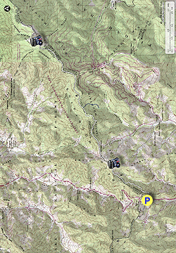
  • Mile 0.0 โ€“ From Sams Gap locate the Appalachian Trail white blaze on the north/right side of I-26. Follow the Appalachian Trail beside the interstate.
  • Mile 0.1 โ€“ Turn right on the AT leaving the interstate clearing and switchbacking above heading south then east Sams Gap.
  • Mile 0.4 โ€“ The AT swings north entering deciduous forest.
  • Mile 0.9 โ€“ Begin a steep climb to the summit of West Street Gap Peak. This 0.9-mile climb over 600 feet is the toughest of the day.
  • Mile 1.8 โ€“ Reach the summit of West Street Gap Peak (4,440 feet). There are campsites on each side of the trail, although camping here is discouraged because the sites are too close to the trail. The trail leaves the forest on the east side of the summit passing through a maintained grassy field with views north of Big Bald and northeast of Wolf Ridge Ski Resort.
  • Mile 2.0 โ€“ The trail descends via switchbacks towards Street Gap. Avoid the obvious eroded paths that head straight down bypassing the switchbacks.
  • Mile 2.3 โ€“ At Street Gap the Appalachian Trail crosses S.R. 1502/Streets Gap Road. On the other side of the gap is a view west through a clearing. You may be able to see I-26 coursing through the mountains far below.
  • Mile 3.8 โ€“ T-junction with Nature Trail on the right, part of the private Wolf Laurel Resort.
  • Mile 5.1 โ€“ A side trail on the left is marked with flagging tape. (This was likely an under-construction reroute for the Appalachian Trail that may now be completed.)
  • Mile 5.2 โ€“ T-junction with a side trail to utilities compound and service road for the Wolf Laurel Resort.
  • Mile 5.3 โ€“ Side trail marked with flagging tape rejoins from the left.
  • Mile 5.8 โ€“ Y-junction with the AT Alternate Trail (blue blaze) on the right. Continue left on the Appalachian Trail which starts climbing a moderately steep grade towards the top of Big Bald. The Alternate Trail can be used to bypass the exposed summit of Big Bald during bad weather.
  • Mile 6.2 โ€“ The trail turns right and gradually leaves the forest behind, emerging onto a vast grassy bald as you near the summit.
  • Mile 6.4 โ€“ Reach the summit of Big Bald. At 5,516 feet, this is the tallest peak in the Bald Mountains that straddle the North Carolina/Tennessee border and the tallest peak for 148 miles of the Appalachian Trail between the Great Smoky Mountains to the southwest and the Roan Highlands to the northeast. Immediately south you can see the houses and ski slopes of the Wolf Ridge Ski Resort. Further south the I-26 corridor leads to Asheville. To the south-southeast the Great Craggy Mountains and Black Mountains dominate the region. You may be able to spot the notable summits of Linville Gorge in the distant east. The first big peak in the north-northeast direction is Unaka Mountain, with the much taller peaks of the Roan Highlands further behind in the northeast direction. Almost due north the Nolichucky River sharply cuts between the mountains of Tennessee leading to Erwin and eventually Johnson City. To the southwest the Bald Mountains and Newfound Mountains seem noticeably small in the forefront of the Great Smoky Mountains.

    If you have time you should continue north on the Appalachian Trail to Big Stamp, a bald sub peak of Big Bald. You can see open grass extending to Big Stamp from Big Bald, it is less than a mile between the peaks. After youโ€™re done exploring the area turn around and head south on the AT towards Sams Gap.
  • Mile 12.9 โ€“ Hike ends at Sams Gap.
By HikingUpward Contributor: Zach Robbins
Explore 27 trails near Mars Hill, NC
  1. Parking

    35.952378, -82.560802
  2. Main Trailhead

    35.952654, -82.560754
No community routes found. To add your own hike as a Community Route for this Trail guide, leave a Trip Report with an attached GPX file.

Hazards

Snakes
Poison Ivy/Oak

Seasons

All

Blaze Color

White

Trip Reports

Trail Guide By:
HikingUpward user profile picture
12.9 miles / 20.8 km

Weather Forecast

In Mars Hill, NC

Explore Hiking Trails

You May Also Like

Colorado's Million Dollar Highway - Plan a day's drive adventure along the iconic Million Dollar Highway in Colorado. Explore the best short trails, roadside stops, waterfalls, vistas, ghost towns, and hot springs within a ~6 hour road trip.
Explore

Colorado's Million Dollar Highway

Plan a day's drive adventure along the iconic Million Dollar Highway in Colorado. Explore the best short trails, roadside stops, waterfalls, vistas, ghost towns, and hot springs within a ~6 hour road trip.

Read
Glacier's Going-to-the-Sun Road - Discover the breathtaking beauty of Glacier National Park along the iconic Going-to-the-Sun Road. From stunning roadside stops to picturesque waterfalls and vistas, this engineering marvel offers endless opportunities for exploration.
Explore

Glacier's Going-to-the-Sun Road

Discover the breathtaking beauty of Glacier National Park along the iconic Going-to-the-Sun Road. From stunning roadside stops to picturesque waterfalls and vistas, this engineering marvel offers endless opportunities for exploration.

Read
New York's Best Waterfalls - Whether you're planning a day hike, roadside stop, or a leisurely short walk, this guide provides hikers, travelers, and locals alike with 63 different locations to over 100 scenic waterfalls to help plan your next adventure!
Explore

New York's Best Waterfalls

Whether you're planning a day hike, roadside stop, or a leisurely short walk, this guide provides hikers, travelers, and locals alike with 63 different locations to over 100 scenic waterfalls to help plan your next adventure!

Read
25 Best Day Hikes in North Carolina - Discover the top 25 best day hikes in North Carolina, from breathtaking waterfalls to mountain peaks. Explore hidden gems, scenic views, and trails suitable for all skill levels, perfect for your next outdoor adventure.
Explore

25 Best Day Hikes in North Carolina

Discover the top 25 best day hikes in North Carolina, from breathtaking waterfalls to mountain peaks. Explore hidden gems, scenic views, and trails suitable for all skill levels, perfect for your next outdoor adventure.

Read

Before you boogie...

Find our trail guides useful? Consider becoming a Supporter to unlock perks!

MyHikes is an indie platform that makes exploring public trails easier for everyone. The platform has no investors, no ads, and is owned and operated by one person, Dave Miller. Dave has personally mapped and written over 1,800 trail guides on MyHikes for the public to explore. MyHikes has helped millions outdoor enthusiasts plan their next adventure.

But it takes a lot of time ๐Ÿ•ฆ, money ๐Ÿ’ฐ, work, and espresso shots โ˜• to run MyHikes, including hiking , mapping , writing , and publishing new trails with high-quality (accurate) information... along with software engineering (coding) the platform like building new features, website and mobile app development (iOS and Android), site maintainance . and much much more.

Supporters unlock website and mobile app perks with an annual one-time payment of $25 (you renew) ๐Ÿ˜Ž๐Ÿ‘. Or you can simply make a Donation of your choice. Otherwise, you can support us by telling your friends about MyHikes - both quick and free ๐ŸŽ‰

Admin user profile picture

Dave Miller
MyHikes Founder