Loading...

๐ŸŽ‰ Enjoy a Free 7-Day Supporter Trial and Unlock Exclusive Perks โ€” No Credit Card Required. Learn more.

Bearwallow Mountain and Blue Ridge Pastures Hike

Directions
Map
Pictures
Send to App
Distance:
6.8 Miles / 10.9 km
Type:
Out-and-Back
Difficulty:
Moderate
Time to Hike:
3 hours, ~24 minutes
Features:
Surface Type:
Dirt
Town:
Hendersonville, North Carolina
Directions:
35.460416, -82.368451
Added:
March 22, 2025
Updated:
April 06, 2025
Copy Trail Link Hiking this trail? Send a friend or family member a link to this trail guide for your own safety. Hike at your own risk (disclaimer)
Loading...
Loading...
1,106'

Total Change
2,006'

Ascent
1,994'

Descent

Download the Trail Route for Offline Use

Supporters get exclusive access to download trail routes to the MyHikes app for offline use. Stay prepared on your adventure, even without an internet connection! Become a Supporter today to unlock this feature and hike with confidence.

Send to App

Bearwallow Mountain and Blue Ridge Pastures Hike

Two of the newest trails in the Hickory Nut Gorge region provide stunning views with minimal effort. From lofty Bearwallow Gap on the Eastern Continental Divide you can choose the short hike to the popular bald summit of Bearwallow Mountain or the longer hike along the Trombatore Trail to a small bald known as Blue Ridge Pastures.

From Bearwallow Mountain youโ€™ll be treated to sweeping views of Western North Carolina while Blue Ridge Pastures offers a unique view down the rugged Hickory Nut Gorge. Both mountains provide excellent northern views of the Swannanoa Mountains, Black Mountains and Great Craggy Mountains. This page describes both hikes which make an excellent half day excursion or choose one for a picnic on a sunny day.
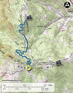
  • Mile 0.0 โ€“ There is ample parking on both sides of Bearwallow Mountain Road after the road crests Bearwallow Gap and turns to pavement. At the gap the Bearwallow Trail begins on the east side while the Trombatore Trail begins on the west side. This hike begins with the Bearwallow Trail (white blaze). The new Bearwallow Trail climbs gently on many switchbacks up the west side of the mountain through hardwood forests. The alternative route to the summit follows the forest road to the left and they are roughly the same length.
  • Mile 0.9 โ€“ Trail leaves the forest traversing the immense bald summit of Bearwallow Mountain. As you approach the communications towers you will have constant views south of the Green River Game Lands region and the Kings Mountain Range on a clear day.
  • Mile 1.1 โ€“ Summit of Bearwallow Mountain (4,232 feet) adorned with communications structures and an old fire tower. The steel Aermotor tower was constructed in 1934 but is normally closed to access. From the mountain top youโ€™ll have outstanding views in every direction except east, which is blocked by gnarled trees. Due north is Little Pisgah Mountain, the tallest peak in the Hickory Nut Gorge area. On the left are the Swannanoa Mountains followed by the Great Craggy Mountains and Black Mountains dominating the region. The Brush Creek Valley lies to the northwest with Asheville out of sight. You can spot the Great Balsam Mountains to the west on a clear day. The easiest peak to spot in this range is the TV tower adorned Mt. Pisgah, the pyramidal mountain on the right side of the high ridge.  
  • Mile 2.4 โ€“ Bearwallow Mountain hike ends at Bearwallow Gap. For the second part of the hike find the Trombatore Trail (no blaze) on the opposite side of the street. You will see a wood sign board with no information beyond a small gap in the fencing. The trail moderately descends on switchbacks towards Brush Creek.
  • Mile 3.6 โ€“ Trail crosses over Brush Creek. Beyond this point many forest roads crisscross the trail since it mostly borders private property. At almost all intersections are temporary plastic signs indicating the direction of the Trombatore Trail.
  • Mile 4.2 โ€“ At a confusing 5-way intersection veer slightly left on the Trombatore Trail. The trail actually makes a loop around the summit. The wide road bed heading straight and uphill is the shortest version but it is steep. This hike takes the hikerโ€™s path and returns along the forest road.
  • Mile 5.0 โ€“ Climb over a cow stile and enter the vast grassy bald of Blue Ridge Pastures. Go left towards the end of the bald for the best views.
  • Mile 5.1 โ€“ On the north side of Blue Ridge Pastures is a fire ring in a beautiful spot with views north and east. This tract is part of a conservation easement purchased by the Southern Appalachian Highlands Conservancy and will be part of a larger trail system around the Hickory Nut Gorge. Unlike Bearwallow Mountain you have a direct view of the Hickory Nut Gorge. Shumont Mountain rises high above the cliffs of Round Top Mountain and Rumbling Bald marking the eastern end of the gorge where the Broad River flows into Lake Lure. To the southeast the double-humped massif of Little Bearwallow Mountain and Bearwallow Mountain rises high above the landscape. It is easy to pick out your starting spot at Bearwallow Gap. Perhaps the most dramatic view is north of Little Pisgah Mountain with the Great Craggy and Black mountain ranges in the distance.
  • Mile 5.3 โ€“ Instead of going back over the cow stile, continue south along the loop following the forest road down the mountain.
  • Mile 5.4 โ€“ Descend through grassy fields dotted with large trees. Good winter views of Bearwallow Mountain through this section.
  • Mile 5.6 โ€“ Forest road levels out at the loop trail intersection. Follow the Trombatore Trail back to the parking area.
  • Mile 6.8 โ€“ Hike ends at Bearwallow Gap.
By HikingUpward Contributor: Zach Robbins
Explore 27 trails near Hendersonville, NC
  1. Parking

    35.460416, -82.368451
  2. Main Trailhead

    35.46088, -82.367806
No community routes found. To add your own hike as a Community Route for this Trail guide, leave a Trip Report with an attached GPX file.

Hazards

Snakes
Poison Ivy/Oak

Seasons

All

Weather Forecast

In Hendersonville, NC

Explore Hiking Trails

You May Also Like

Colorado's Million Dollar Highway - Plan a day's drive adventure along the iconic Million Dollar Highway in Colorado. Explore the best short trails, roadside stops, waterfalls, vistas, ghost towns, and hot springs within a ~6 hour road trip.
Explore

Colorado's Million Dollar Highway

Plan a day's drive adventure along the iconic Million Dollar Highway in Colorado. Explore the best short trails, roadside stops, waterfalls, vistas, ghost towns, and hot springs within a ~6 hour road trip.

Read
Glacier's Going-to-the-Sun Road - Discover the breathtaking beauty of Glacier National Park along the iconic Going-to-the-Sun Road. From stunning roadside stops to picturesque waterfalls and vistas, this engineering marvel offers endless opportunities for exploration.
Explore

Glacier's Going-to-the-Sun Road

Discover the breathtaking beauty of Glacier National Park along the iconic Going-to-the-Sun Road. From stunning roadside stops to picturesque waterfalls and vistas, this engineering marvel offers endless opportunities for exploration.

Read
New York's Best Waterfalls - Whether you're planning a day hike, roadside stop, or a leisurely short walk, this guide provides hikers, travelers, and locals alike with 63 different locations to over 100 scenic waterfalls to help plan your next adventure!
Explore

New York's Best Waterfalls

Whether you're planning a day hike, roadside stop, or a leisurely short walk, this guide provides hikers, travelers, and locals alike with 63 different locations to over 100 scenic waterfalls to help plan your next adventure!

Read
25 Best Day Hikes in North Carolina - Discover the top 25 best day hikes in North Carolina, from breathtaking waterfalls to mountain peaks. Explore hidden gems, scenic views, and trails suitable for all skill levels, perfect for your next outdoor adventure.
Explore

25 Best Day Hikes in North Carolina

Discover the top 25 best day hikes in North Carolina, from breathtaking waterfalls to mountain peaks. Explore hidden gems, scenic views, and trails suitable for all skill levels, perfect for your next outdoor adventure.

Read

Before you boogie...

Find our trail guides useful? Consider becoming a Supporter to unlock perks!

MyHikes is an indie platform that makes exploring public trails easier for everyone. The platform has no investors, no ads, and is owned and operated by one person, Dave Miller. Dave has personally mapped and written over 1,800 trail guides on MyHikes for the public to explore. MyHikes has helped millions outdoor enthusiasts plan their next adventure.

But it takes a lot of time ๐Ÿ•ฆ, money ๐Ÿ’ฐ, work, and espresso shots โ˜• to run MyHikes, including hiking , mapping , writing , and publishing new trails with high-quality (accurate) information... along with software engineering (coding) the platform like building new features, website and mobile app development (iOS and Android), site maintainance . and much much more.

Supporters unlock website and mobile app perks with an annual one-time payment of $25 (you renew) ๐Ÿ˜Ž๐Ÿ‘. Or you can simply make a Donation of your choice. Otherwise, you can support us by telling your friends about MyHikes - both quick and free ๐ŸŽ‰

Admin user profile picture

Dave Miller
MyHikes Founder