The Bear Run Waterfall Loop at Tioga State Forest, and at the edge of Colton Point State Park, near Wellsboro, Pennsylvania is a moderate 0.8-mile loop hike that follows the Bear Run Creek to several waterfalls between 4 and 35-feet tall.
Hike Description
This is mostly a bushwhack that leads out to four main waterfalls, one seasonal waterfall, and several shorter cascades along Bear Run. For those who do not like hiking without following a trail, or do not have experience bushwhacking, this hike is not for you.
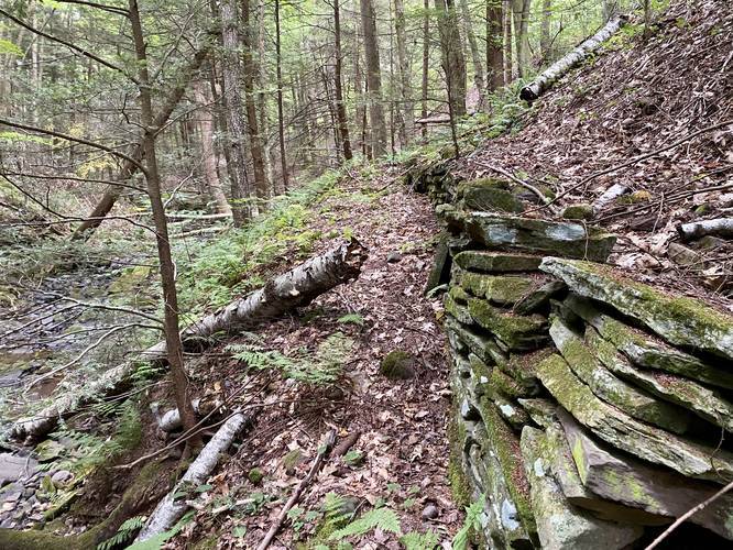
The hike begins along the West Rim Trail, at the Colton Point State Park sign, just outside of the state park boundaries in Tioga State Forest. Hikers will follow the West Rim Trail for no more than 200-feet from the road before they should notice an old log-slide "trail" that meanders its way to the right-hand side of the West Rim Trail. This old log-slide runs between Bear Run Creek and the West Rim Trail. If you cannot find the old log-slide, then the easiest way to find the waterfalls is to follow the creek itself -- this is exactly what the GPS track does in the first half of this trek.
By following the creek itself, hikers cannot miss the waterfalls; however, depending on the time of year, you may end up getting your feet wet. If you hike this after mid-June, the creek should be dry enough to hike across without any issues.
Bear Run's Waterfalls (Bear Run Falls, Hillside Falls, and Slab Falls)
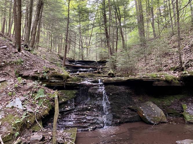
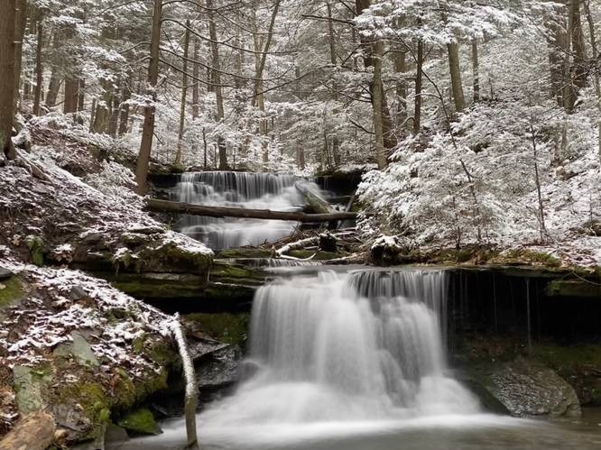
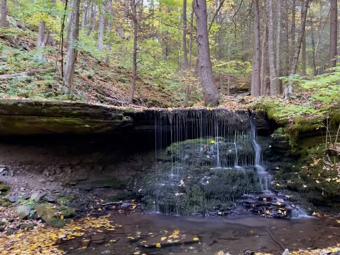
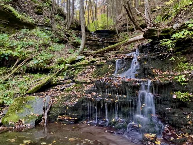
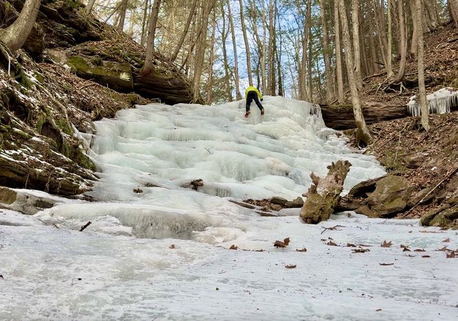
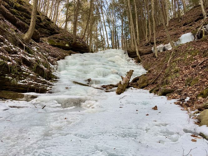
About 0.3-miles into following Bear Run Creek, hikers will reach two waterfalls. The Upper Bear Run Falls is about 10-feet tall and approximately 10-feet wide. The lower cascade just downstream is about 4-feet tall and is much skinnier when the water level is low. Just beyond the lower falls is a seasonal cascade that spills down into Bear Run during the Spring and is located on the south side of the gorge's slopes, Hillside Falls. And just beyond that is another 7-foot tall free-falling waterfall named Slab Falls. Slab Falls spills downstream adjacent to a massive rock slab overhang that juts out about 7-feet or so, hence the name. Just downstream of Slab Falls is a very small waterfall that's no taller than about 2-feet. Bear Fun Falls (both tiers), Hillside Falls, and Slab Falls, which includes four separate cascades, can all be found within 200-feet of one another along the creek.
Step Falls & Little Step Falls (i,e. Bear Run Falls Major)
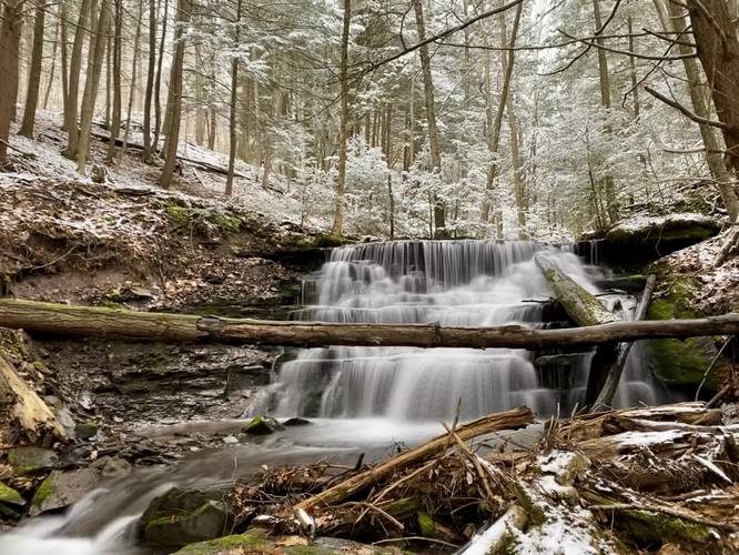
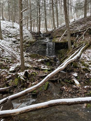
After exploring the upper waterfalls, hikers may want to see the largest, but most difficult-to-reach, waterfall along the run - Step Falls. Hikers will want to head back uphill along the gorge's northern banks to hike south along the very top of Bear Run creek. About a quarter-mile downstream the banks will become very steep as they slope downhill toward Step Falls (Bear Run Falls Major), which is a 35-foot waterfall within the gorge. At the slopes of Step Falls hikers can slowly scramble their way down the hillside to reach the base of the 35-foot waterfall for a better view; however, this can be very dangerous - only experienced off-trail gorge hikers should attempt reaching the base of this waterfall. Once on the slippery bedrock, hikers can get a nice view of Step Falls (Bear Run Falls Major) before checking out one last cascade before hiking back - Little Step Falls. Just downstream is a 7-foot tall waterfall that looks like a miniature version of Step Falls, hence the name, Little Step Falls. Little Step Falls, while not spectacular, actually gives quite a nice view of the larger Step Falls cascading downstream in the background.
Hike Back - Old-Growth Hemlock Grove
The hike back to parking is a bit tricky. Just upstream from the waterfall, hikers should note a slight switchback grade that heads up the hillside. Follow this old log-slide trail and then take a sharp left-hand turn to head through the mountain laurel. Hikers should be able to spot the log-slide that runs adjacent to the creek, just uphill. Along the way is a beautiful old-growth hemlock forest, located directly on this old logging grade. Follow this old log-slide until you reach what feels like a dead-end. At this point, take a right-hand turn and hike for about 15-feet to reach the West Rim Trail once again. Follow the WRT out to the parking lot to complete the hike.
Parking
Hikers will find a small parking area at the coordinates provided. This parking area is large enough to fit 2 or 3 cars.
Pets
Dogs are allowed if leashed.
Blazes
This trail has no blazes other than along the WRT. Bring a map and/or download this GPX file before you head out if you do not feel comfortable navigating the woods without a digital map.
Warnings
Rattlesnakes: While rare, the Timber Rattlesnake lives in this area and tends to come down to creeks to cool down or hunt between the end of April through the end of September. Watch your step and give any rattlesnake you see some space.
Bushwhack: This hike is off-trail and requires map-reading skills.
Hike Description
This is mostly a bushwhack that leads out to four main waterfalls, one seasonal waterfall, and several shorter cascades along Bear Run. For those who do not like hiking without following a trail, or do not have experience bushwhacking, this hike is not for you.
The hike begins along the West Rim Trail, at the Colton Point State Park sign, just outside of the state park boundaries in Tioga State Forest. Hikers will follow the West Rim Trail for no more than 200-feet from the road before they should notice an old log-slide "trail" that meanders its way to the right-hand side of the West Rim Trail. This old log-slide runs between Bear Run Creek and the West Rim Trail. If you cannot find the old log-slide, then the easiest way to find the waterfalls is to follow the creek itself -- this is exactly what the GPS track does in the first half of this trek.
By following the creek itself, hikers cannot miss the waterfalls; however, depending on the time of year, you may end up getting your feet wet. If you hike this after mid-June, the creek should be dry enough to hike across without any issues.
Bear Run's Waterfalls (Bear Run Falls, Hillside Falls, and Slab Falls)
About 0.3-miles into following Bear Run Creek, hikers will reach two waterfalls. The Upper Bear Run Falls is about 10-feet tall and approximately 10-feet wide. The lower cascade just downstream is about 4-feet tall and is much skinnier when the water level is low. Just beyond the lower falls is a seasonal cascade that spills down into Bear Run during the Spring and is located on the south side of the gorge's slopes, Hillside Falls. And just beyond that is another 7-foot tall free-falling waterfall named Slab Falls. Slab Falls spills downstream adjacent to a massive rock slab overhang that juts out about 7-feet or so, hence the name. Just downstream of Slab Falls is a very small waterfall that's no taller than about 2-feet. Bear Fun Falls (both tiers), Hillside Falls, and Slab Falls, which includes four separate cascades, can all be found within 200-feet of one another along the creek.
Step Falls & Little Step Falls (i,e. Bear Run Falls Major)
After exploring the upper waterfalls, hikers may want to see the largest, but most difficult-to-reach, waterfall along the run - Step Falls. Hikers will want to head back uphill along the gorge's northern banks to hike south along the very top of Bear Run creek. About a quarter-mile downstream the banks will become very steep as they slope downhill toward Step Falls (Bear Run Falls Major), which is a 35-foot waterfall within the gorge. At the slopes of Step Falls hikers can slowly scramble their way down the hillside to reach the base of the 35-foot waterfall for a better view; however, this can be very dangerous - only experienced off-trail gorge hikers should attempt reaching the base of this waterfall. Once on the slippery bedrock, hikers can get a nice view of Step Falls (Bear Run Falls Major) before checking out one last cascade before hiking back - Little Step Falls. Just downstream is a 7-foot tall waterfall that looks like a miniature version of Step Falls, hence the name, Little Step Falls. Little Step Falls, while not spectacular, actually gives quite a nice view of the larger Step Falls cascading downstream in the background.
Hike Back - Old-Growth Hemlock Grove
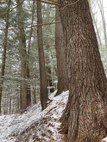
The hike back to parking is a bit tricky. Just upstream from the waterfall, hikers should note a slight switchback grade that heads up the hillside. Follow this old log-slide trail and then take a sharp left-hand turn to head through the mountain laurel. Hikers should be able to spot the log-slide that runs adjacent to the creek, just uphill. Along the way is a beautiful old-growth hemlock forest, located directly on this old logging grade. Follow this old log-slide until you reach what feels like a dead-end. At this point, take a right-hand turn and hike for about 15-feet to reach the West Rim Trail once again. Follow the WRT out to the parking lot to complete the hike.
Parking
Hikers will find a small parking area at the coordinates provided. This parking area is large enough to fit 2 or 3 cars.
Pets
Dogs are allowed if leashed.
Blazes
This trail has no blazes other than along the WRT. Bring a map and/or download this GPX file before you head out if you do not feel comfortable navigating the woods without a digital map.
Warnings
Rattlesnakes: While rare, the Timber Rattlesnake lives in this area and tends to come down to creeks to cool down or hunt between the end of April through the end of September. Watch your step and give any rattlesnake you see some space.
Bushwhack: This hike is off-trail and requires map-reading skills.