Loading...

🎆 50% off 4th of July sale on Supporter Accounts — now through July 6! Learn More.

Bear Loop

Directions
Map
Pictures
Send to App
Distance:
1.3 km / 0.8 Miles
Type:
Loop
Difficulty:
Easy
Time to Hike:
~24 minutes
Features:
Surface Type:
Dirt
Park:
Thousand Islands National Park
Town:
Mallorytown, Ontario - Canada
Directions:
44.489346, -75.821241
Added:
October 07, 2024
Updated:
December 19, 2024
Copy Trail Link Hiking this trail? Send a friend or family member a link to this trail guide for your own safety. Hike at your own risk (disclaimer)
Loading...
Loading...
20m

Total Change
18m

Ascent
21m

Descent

Download the Trail Route for Offline Use

Supporters get exclusive access to download trail routes to the MyHikes app for offline use. Stay prepared on your adventure, even without an internet connection! Become a Supporter today to unlock this feature and hike with confidence.

Send to App

Bear Loop

The Bear Loop at Thousand Islands National Park near Mallorytown, Ontario is an easy 1.2 km loop hike that features a scenic rock ledge deep in the forest, dark hemlock groves, and connects to the scenic Heron Loop.

Hiking the Bear Loop

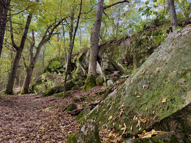
The Bear Loop begins at the very end of the Jones Creek Trail, which connects the parking lot to the main trail system within the Jones Creek section of the park. At the trailhead, the Bear Loop follows blue blazes heading west and follows short hills that undulate through the forest.

Scenic Rock Ledge - 0.27 km

Just 0.27 km from the trailhead, hikers will find a long rock ledge that runs through the forest. The trail runs alongside the ledge and provides access to fun scrambling opportunities or pictures of the mossy ledge sitting under the canopy of the Jones Creek forest. This rock ledge, while seemingly uninteresting, is likely the main attraction on the trail, so you might want to explore the Heron Loop along with this trail while you're at it.

After exploring the rock ledge, the Bear Loop runs northward until reaching a left-hand to to the Heron Loop. Here, the trail continues onward to follow the orange blazes of the Turtle Loop, turns right and follows the yellow blazes of the Eel Loop, and finally ends at the trailhead for a 1.2 km hike.

Parking & Fees

Hikers will find a small parking lot at the coordinates provided, located on the north side of 1000 Islands Parkway in Mallorytown, ON. The lot is large enough to fit less than 12 vehicles as of October 2024. There's a parking fee of about $10 (in 2024), which can be paid by QR code found in front of parking spaces.

Pets

Dogs are allowed if leashed and cleaned up after.
Explore 2 trails near Mallorytown, ON
  1. Parking

    44.489346, -75.821241
  2. Main Trailhead

    44.492077, -75.823614
  3. Scenic rocky ledge

    44.492497, -75.825722
    Scenic rocky ledge
No community routes found. To add your own hike as a Community Route for this Trail guide, leave a Trip Report with an attached GPX file.

Hazards

Poison Ivy/Oak

Seasons

All

Blaze Color

Blue

Photo Albums

Trip Reports

Trail Guide By:
Admin user profile picture
0.8 miles / 1.3 km
0.8 miles / 1.3 km
October 07, 2024
Hiking

Weather Forecast

In Mallorytown, ON

Explore Hiking Trails

You May Also Like

Colorado's Million Dollar Highway - Plan a day's drive adventure along the iconic Million Dollar Highway in Colorado. Explore the best short trails, roadside stops, waterfalls, vistas, ghost towns, and hot springs within a ~6 hour road trip.
Explore

Colorado's Million Dollar Highway

Plan a day's drive adventure along the iconic Million Dollar Highway in Colorado. Explore the best short trails, roadside stops, waterfalls, vistas, ghost towns, and hot springs within a ~6 hour road trip.

Read
Glacier's Going-to-the-Sun Road - Discover the breathtaking beauty of Glacier National Park along the iconic Going-to-the-Sun Road. From stunning roadside stops to picturesque waterfalls and vistas, this engineering marvel offers endless opportunities for exploration.
Explore

Glacier's Going-to-the-Sun Road

Discover the breathtaking beauty of Glacier National Park along the iconic Going-to-the-Sun Road. From stunning roadside stops to picturesque waterfalls and vistas, this engineering marvel offers endless opportunities for exploration.

Read
New York's Best Waterfalls - Whether you're planning a day hike, roadside stop, or a leisurely short walk, this guide provides hikers, travelers, and locals alike with 63 different locations to over 100 scenic waterfalls to help plan your next adventure!
Explore

New York's Best Waterfalls

Whether you're planning a day hike, roadside stop, or a leisurely short walk, this guide provides hikers, travelers, and locals alike with 63 different locations to over 100 scenic waterfalls to help plan your next adventure!

Read

Before you boogie...

Find our trail guides useful? Consider becoming a Supporter to unlock perks!

MyHikes is an indie platform that makes exploring public trails easier for everyone. The platform has no investors, no ads, and is owned and operated by one person, Dave Miller. Dave has personally mapped and written over 1,800 trail guides on MyHikes for the public to explore. MyHikes has helped millions outdoor enthusiasts plan their next adventure.

But it takes a lot of time 🕦, money 💰, work, and espresso shots ☕ to run MyHikes, including hiking , mapping , writing , and publishing new trails with high-quality (accurate) information... along with software engineering (coding) the platform like building new features, website and mobile app development (iOS and Android), site maintainance . and much much more.

Supporters unlock website and mobile app perks with an annual one-time payment of $25 (you renew) 😎👍. Or you can simply make a Donation of your choice. Otherwise, you can support us by telling your friends about MyHikes - both quick and free 🎉

Admin user profile picture

Dave Miller
MyHikes Founder