Loading...

🎉 Enjoy a Free 7-Day Supporter Trial and Unlock Exclusive Perks — No Credit Card Required. Learn more.

Beacon Heights Hike

Directions
Map
Pictures
Send to App
Distance:
0.8 Miles / 1.3 km
Type:
Out-and-Back
Difficulty:
Easy
Time to Hike:
~24 minutes
Features:
Surface Type:
Dirt
Park:
Pisgah National Forest
Town:
Linville, North Carolina
Directions:
36.083906, -81.830115
Added:
March 13, 2025
Updated:
April 05, 2025
Copy Trail Link Hiking this trail? Send a friend or family member a link to this trail guide for your own safety. Hike at your own risk (disclaimer)
Loading...
Loading...
140'

Total Change
163'

Ascent
159'

Descent

Download the Trail Route for Offline Use

Supporters get exclusive access to download trail routes to the MyHikes app for offline use. Stay prepared on your adventure, even without an internet connection! Become a Supporter today to unlock this feature and hike with confidence.

Send to App

Beacon Heights Hike

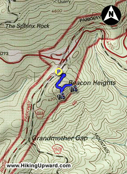
One of the finest slices of the Blue Ridge Parkway is the winding stretch on the east side of Grandfather Mountain. Here the Tanawha Trail runs parallel to the parkway for 13 miles, providing many opportunities for short or moderate hikes. At the southern terminus of the Tanawha Trail lies Beacon Heights, a series of large, east-facing cliffs with outstanding views of Grandfather Mountain, Grandmother Mountain, and the Wilson Creek basin. From the Beacon Heights Overlook the cliffs can be reached by an easy 0.3-mi trail that is a perfect quick stop while traveling on the Blue Ridge Parkway for hikers of all ages and abilities.  

  • Mile 0.0 – Beacon Heights Overlook parking beside the Blue Ridge Parkway. You might simply enjoy the view from the parking area as Grandfather Mountain towers over the landscape. Pick up the signed, but unblazed trail on the east side of the parking lot heading into the woods.
  • Mile 0.1 – Junction with the Tanawha Trail (white blaze) and Mountains-to-Sea Trail (MST). Turn right following the Tanawha Trail + MST.
  • Mile 0.2 – At T-junction the Mountains-to-Sea Trail continues south/right. Turn left following the sign to Beacon Heights.
  • Mile 0.3 – The trail splits at a bench. Turn left for the first overlook area in 100 feet. From this expansive cliff the rounded summit of Grandmother Mountain with its communications tower dominates the surroundings. To the left of the mountain lies the Wilson Creek basin. In the distance to the left of the summit you can see the distinctive peaks of Linville Gorge.
  • Mile 0.4 – Turn right at the bench and follow the unsigned trail to the second overlook.
  • Mile 0.5 – Trail ends at the second overlook. Even though this cliff is easily reachable it receives much less traffic than the first overlook. The vista is shifted here, ranging from Grandfather Mountain to the Wilson Creek basin with Grandmother Mountain peeking above the trees. The rocky MacRae Peak and Attic Window Peak rise high above the Blue Ridge Parkway.
  • Mile 0.8 – Hike ends at parking area.
By HikingUpward Contributor: Zach Robbins
Explore 31 trails near Linville, NC
  1. Parking

    36.083906, -81.830115
  2. Main Trailhead

    36.083906, -81.830115
No community routes found. To add your own hike as a Community Route for this Trail guide, leave a Trip Report with an attached GPX file.

Hazards

Snakes
Poison Ivy/Oak

Seasons

All

Blaze Color

White

Trip Reports

Trail Guide By:
HikingUpward user profile picture
0.8 miles / 1.3 km

Weather Forecast

In Linville, NC

Explore Hiking Trails

You May Also Like

Colorado's Million Dollar Highway - Plan a day's drive adventure along the iconic Million Dollar Highway in Colorado. Explore the best short trails, roadside stops, waterfalls, vistas, ghost towns, and hot springs within a ~6 hour road trip.
Explore

Colorado's Million Dollar Highway

Plan a day's drive adventure along the iconic Million Dollar Highway in Colorado. Explore the best short trails, roadside stops, waterfalls, vistas, ghost towns, and hot springs within a ~6 hour road trip.

Read
Glacier's Going-to-the-Sun Road - Discover the breathtaking beauty of Glacier National Park along the iconic Going-to-the-Sun Road. From stunning roadside stops to picturesque waterfalls and vistas, this engineering marvel offers endless opportunities for exploration.
Explore

Glacier's Going-to-the-Sun Road

Discover the breathtaking beauty of Glacier National Park along the iconic Going-to-the-Sun Road. From stunning roadside stops to picturesque waterfalls and vistas, this engineering marvel offers endless opportunities for exploration.

Read
New York's Best Waterfalls - Whether you're planning a day hike, roadside stop, or a leisurely short walk, this guide provides hikers, travelers, and locals alike with 63 different locations to over 100 scenic waterfalls to help plan your next adventure!
Explore

New York's Best Waterfalls

Whether you're planning a day hike, roadside stop, or a leisurely short walk, this guide provides hikers, travelers, and locals alike with 63 different locations to over 100 scenic waterfalls to help plan your next adventure!

Read
25 Best Day Hikes in North Carolina - Discover the top 25 best day hikes in North Carolina, from breathtaking waterfalls to mountain peaks. Explore hidden gems, scenic views, and trails suitable for all skill levels, perfect for your next outdoor adventure.
Explore

25 Best Day Hikes in North Carolina

Discover the top 25 best day hikes in North Carolina, from breathtaking waterfalls to mountain peaks. Explore hidden gems, scenic views, and trails suitable for all skill levels, perfect for your next outdoor adventure.

Read

Before you boogie...

Find our trail guides useful? Consider becoming a Supporter to unlock perks!

MyHikes is an indie platform that makes exploring public trails easier for everyone. The platform has no investors, no ads, and is owned and operated by one person, Dave Miller. Dave has personally mapped and written over 1,800 trail guides on MyHikes for the public to explore. MyHikes has helped millions outdoor enthusiasts plan their next adventure.

But it takes a lot of time 🕦, money 💰, work, and espresso shots ☕ to run MyHikes, including hiking , mapping , writing , and publishing new trails with high-quality (accurate) information... along with software engineering (coding) the platform like building new features, website and mobile app development (iOS and Android), site maintainance . and much much more.

Supporters unlock website and mobile app perks with an annual one-time payment of $25 (you renew) 😎👍. Or you can simply make a Donation of your choice. Otherwise, you can support us by telling your friends about MyHikes - both quick and free 🎉

Admin user profile picture

Dave Miller
MyHikes Founder