Battle Creek Falls Trail within Uinta National Forest near Pleasant Grove, Utah is a moderate 1.2-mile out-and-back hike that leads to the 60-foot tall waterfall, Battle Creek Falls.
Hike Description
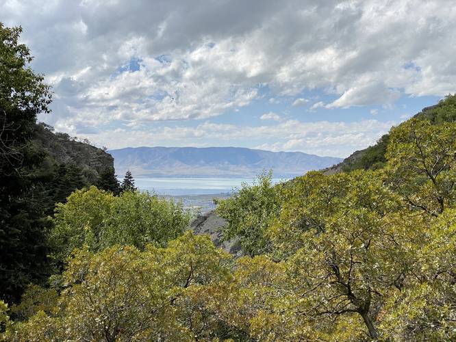
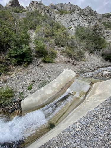
This hike begins at the main parking lot for Kiwanis Park and follows the Battle Creek Trail as it leads up the southwestern slopes of Mt. Timpanogos. The trail itself is wide with a substrate of dirt and includes patches of loose gravel. Hikers will make their way up the Battle Creek valley with views of the Mt. Timpanogos foothills ahead of you. Along the way, hikers will find a small human-made waterfall / spillway located around mile 0.38, which is a neat spot to take a little break.
Battle Creek Footbridge - Mile 0.47
At mile 0.47, hikers will reach a small wooden footbridge that spans Battle Creek. During my early Autumn September hike, the water level was just below this footbridge. I can only assume that during periods of heavy rainfall or snow melt, this footbridge might be impassible, but that's speculation.
Battle Creek Falls - Mile 0.55
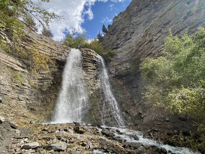
At mile 0.55, hikers will reach a steep but short trail that leads downhill to the base of the ~60-foot tall Battle Creek Falls. Once at the base of Battle Creek Falls, hikers can enjoy cooling down in the mist of the waterfall as it sifts down the canyon.
After visiting Battle Creek Falls, this short route leads hikers back down the same trail to reach parking. Along the way are a couple of nice views of the greater Provo area.
Parking
Hikers will find a large parking lot at the coordinates provided, large enough to fit over a couple dozen vehicles.
Pets
Dogs are allowed on this trail if leashed and must be cleaned up after.
Hike Description
This hike begins at the main parking lot for Kiwanis Park and follows the Battle Creek Trail as it leads up the southwestern slopes of Mt. Timpanogos. The trail itself is wide with a substrate of dirt and includes patches of loose gravel. Hikers will make their way up the Battle Creek valley with views of the Mt. Timpanogos foothills ahead of you. Along the way, hikers will find a small human-made waterfall / spillway located around mile 0.38, which is a neat spot to take a little break.
Battle Creek Footbridge - Mile 0.47
At mile 0.47, hikers will reach a small wooden footbridge that spans Battle Creek. During my early Autumn September hike, the water level was just below this footbridge. I can only assume that during periods of heavy rainfall or snow melt, this footbridge might be impassible, but that's speculation.
Battle Creek Falls - Mile 0.55
At mile 0.55, hikers will reach a steep but short trail that leads downhill to the base of the ~60-foot tall Battle Creek Falls. Once at the base of Battle Creek Falls, hikers can enjoy cooling down in the mist of the waterfall as it sifts down the canyon.
After visiting Battle Creek Falls, this short route leads hikers back down the same trail to reach parking. Along the way are a couple of nice views of the greater Provo area.
Parking
Hikers will find a large parking lot at the coordinates provided, large enough to fit over a couple dozen vehicles.
Pets
Dogs are allowed on this trail if leashed and must be cleaned up after.