Loading...

WINTER SALE! 50% OFF Supporter Accounts — now through January 31st. Learn More.

Bare Mountain

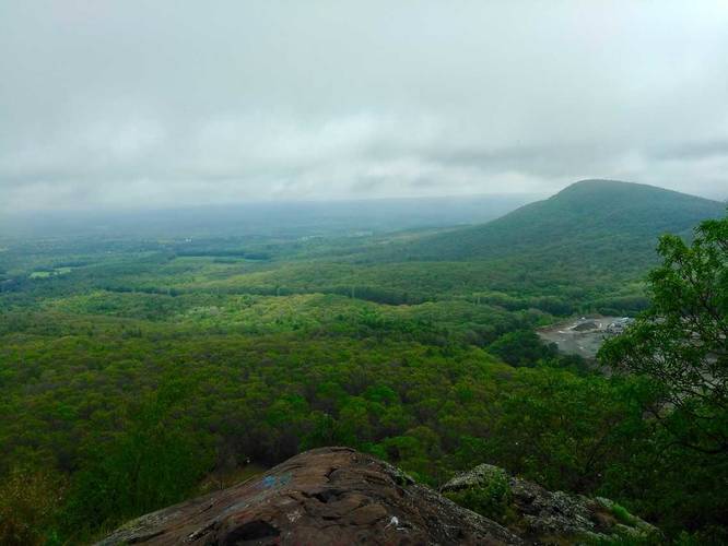
The Bare Mountain Trail is a difficult 1.1-mile out-and-back trail on the Mount Holyoke Range with a lookout that sits 1,014 feet above sea level. From the top, you get sweeping views of Amherst, Hadley, Sunderland, Deerfield, and parts of Belchertown and Pelham.

The trail is moderate to hard, but it can be more difficult for some people. There are various sections that are steep and require hiking up and down rock scrambles.

If you wish to continue exploring the top of the Holyoke Range, you can hike the entire 7 Sisters Trail (due-west to Mount Holyoke) once atop Bare Mountain or continue for just over one mile due-west to the top of Mount Hitchcock along the Mt Hitchcock Trail. Follow the white blazes until you reach your first mountain summit. Follow the trail north until you find a rock edge with the overlook.

Parking: Parking can be found at the Notch Visitor Center and there's a crosswalk that connects the parking lot to the trailhead for the M & M trail / Bare Mountain Trail / 7 Sisters Trail.

Alternative Route: For a different hike up Bare Mountain, check out the Bare Mountain - Old Mill Lane Trail.
Explore 210 trails near Amherst, MA

Know Before You Go

  • Bare Mountain in Amherst, MA, is a challenging 1.1-mile hike to a 1,014-foot summit.
  • The trail offers panoramic views of multiple towns and involves steep sections and rock scrambles.
  • From the summit, hikers can extend their trip by connecting to the 7 Sisters Trail or the Mt Hitchcock Trail.
Interactive topographic map for Bare Mountain located in Amherst, MA. Click the "View Map" button to load GPS coordinates and trail markers.
Get directions
Distance
1.1 mi
Difficulty
Hard
Type
Out-and-Back
Est. Time
33 min
Elev. Gain
500'
Rating
5.0
Added
April 19, 2017
Updated
July 20, 2019

Weather Forecast

Loading...
Total Change
480'
Ascent
500'
Descent
500'
Loading...

Download the GPX Data for Offline Use

Supporters get exclusive access to download trail routes to the MyHikes app for offline use. Stay prepared on your adventure, even without an internet connection! Become a Supporter today to unlock this feature and hike with confidence.

Download Bare Mountain GPX Data to the MyHikes Mobile App

Features

Vista / Lookout Point
Dogs
Mountain Summit

Points of interest

  1. Parking

    42.305004, -72.528517
  2. Main Trailhead

    42.305309, -72.52877

Safety information

For your own safety: plan ahead, let someone know where you'll be, and hike at your own risk.

Availability

Spring

Surface type

Dirt

Trip Reports (Reviews)

Rated 5.0 out of 5 based on 1 rating.

Ready to help fellow hikers? Add a trip report to share your experience and provide valuable insights for other hikers!

1.1 miles / 1.8 km
May 26, 2021
Hiking
1.1 miles / 1.8 km
May 28, 2020
Unbeatable view at the top of this short but steep trail. There are some other great views along the way too. There is a lot of broken glass at the top, so be careful if you have dogs with you.
Hiking
1.0 mile / 1.6 km
December 04, 2018
Hiking
No community routes found. To add your own hike as a Community Route for this Trail guide, leave a Trip Report with an attached GPX file.

Popular categories

Scenic mountain view representing vista trails
Vista trails
Scenic gorge of cascades representing waterfall trails
Waterfall hikes
Rugged mountain terrain representing summit trails
Summit trails
Scenic mountain view representing dog-friendly trails
Dog-friendly
Scenic campsite with a view representing camping trails
Camping trails
Appalachian Trail logo representing A.T. hikes
A.T. hikes

You May Also Like

Colorado's Million Dollar Highway - Plan a day's drive adventure along the iconic Million Dollar Highway in Colorado. Explore the best short trails, roadside stops, waterfalls, vistas, ghost towns, and hot springs within a ~6 hour road trip.
Explore

Colorado's Million Dollar Highway

Plan a day's drive adventure along the iconic Million Dollar Highway in Colorado. Explore the best short trails, roadside stops, waterfalls, vistas, ghost towns, and hot springs within a ~6 hour road trip.

Read
Glacier's Going-to-the-Sun Road - Discover the breathtaking beauty of Glacier National Park along the iconic Going-to-the-Sun Road. From stunning roadside stops to picturesque waterfalls and vistas, this engineering marvel offers endless opportunities for exploration.
Explore

Glacier's Going-to-the-Sun Road

Discover the breathtaking beauty of Glacier National Park along the iconic Going-to-the-Sun Road. From stunning roadside stops to picturesque waterfalls and vistas, this engineering marvel offers endless opportunities for exploration.

Read
🍪 We use cookies to learn about site usage and to serve map tiles. You may block cookies manually in the browser. By continuing you agree. Learn more