The Baldwin Fire Tower Site at Tioga State Forest near Middlebury, Pennsylvania is an easy 0.3-mile out-and-back hike that leads to the remnants of the old Baldwin Fire Tower.
Trails
This hike follows one named trail: Green Monster Trail (yellow blazes).
Hike Description
This is not really a hike, but rather a quick forest walk. The walk begins at the trailhead for the Green Monster Trail and heads uphill and past the yellow service road gate. Along the way, just before the service road gate are some rocky overhang ledges, which appear to have been mined out for potentially flagstone or some other material below, long ago in the 1800s or early 1900s.
Right-Hand Turn - Mile 0.1
Only 0.1 miles into the walk, hikers will take the first right-hand turn they find. It should be obvious as, as of November 2022, there's now a radio transmission tower on site.
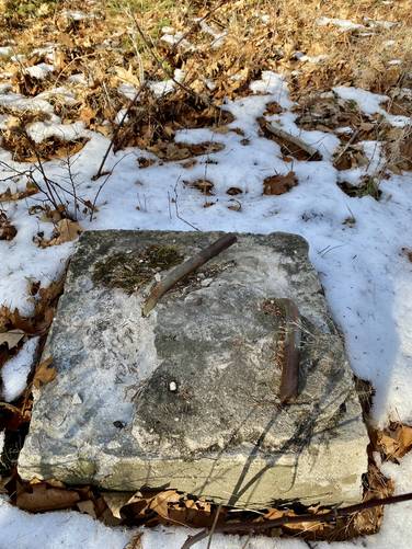
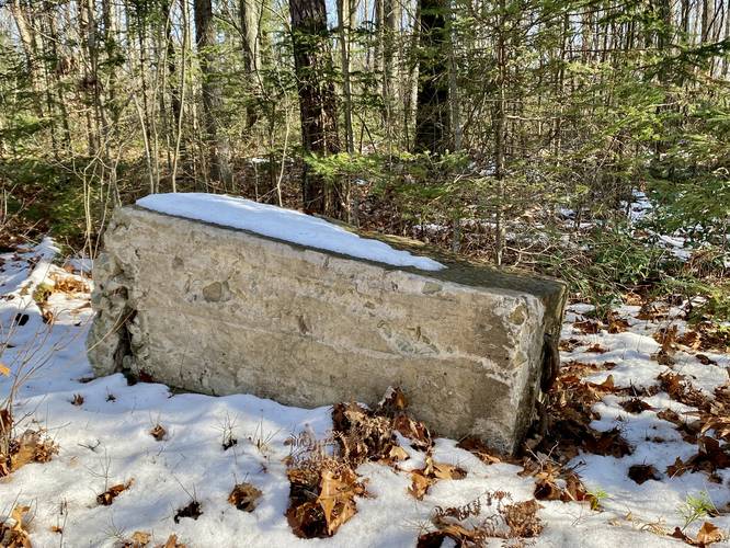
Baldwin Fire Tower Remnants - Mile 0.12
In between the Green Monster Trail and the current radio tower are the old concrete pilings or footings for the fire tower that no longer exists. On the north side, the footings are still in the ground and have their metal rods bent to the side - likely to prevent injury. The two pilings on the south side have been dug up - maybe during the construction of the new radio tower - and now lie on their sides. The pilings are about 3-feet tall and 2-feet or more at their base with their tops (the exposed area with the metal rebar) being over 1-foot in diameter.
Benchmark (Missing)
Despite the Baldwin Fire Tower being gone (no surprise there), the second thing I came to find was the benchmark that used to exist here. According to the USGS data, a benchmark does exist, but I couldn't find it. Maybe you can!
Parking
Hikers will find a small parking lot at the coordinates provided located just off of the road. There is no winter maintenance; however, as of Nov, 2022 (and the previous winter), Baldwin Run Rd has been maintained to keep the fracking industry thriving on the mountain. Drive at your own risk in the winter.
Pets
Dogs are allowed if leashed and their waste should be carried out by the hiker.
Trails
This hike follows one named trail: Green Monster Trail (yellow blazes).
Hike Description
This is not really a hike, but rather a quick forest walk. The walk begins at the trailhead for the Green Monster Trail and heads uphill and past the yellow service road gate. Along the way, just before the service road gate are some rocky overhang ledges, which appear to have been mined out for potentially flagstone or some other material below, long ago in the 1800s or early 1900s.
Right-Hand Turn - Mile 0.1
Only 0.1 miles into the walk, hikers will take the first right-hand turn they find. It should be obvious as, as of November 2022, there's now a radio transmission tower on site.
Baldwin Fire Tower Remnants - Mile 0.12
In between the Green Monster Trail and the current radio tower are the old concrete pilings or footings for the fire tower that no longer exists. On the north side, the footings are still in the ground and have their metal rods bent to the side - likely to prevent injury. The two pilings on the south side have been dug up - maybe during the construction of the new radio tower - and now lie on their sides. The pilings are about 3-feet tall and 2-feet or more at their base with their tops (the exposed area with the metal rebar) being over 1-foot in diameter.
Benchmark (Missing)
Despite the Baldwin Fire Tower being gone (no surprise there), the second thing I came to find was the benchmark that used to exist here. According to the USGS data, a benchmark does exist, but I couldn't find it. Maybe you can!
Parking
Hikers will find a small parking lot at the coordinates provided located just off of the road. There is no winter maintenance; however, as of Nov, 2022 (and the previous winter), Baldwin Run Rd has been maintained to keep the fracking industry thriving on the mountain. Drive at your own risk in the winter.
Pets
Dogs are allowed if leashed and their waste should be carried out by the hiker.