Loading...

❄️ WINTER SALE! 50% OFF on Supporter Accounts — now through January 31st. Unlock a full year of exclusive website & app perks. Learn More.

Bald Knob Ridge to Pinnacle Hike

The Bald Knob Ridge Trail is located in a remote area of the South Toe River Gorge, miles south of the popular Black Mountain Campground in the Appalachian Ranger District of Pisgah National Forest. In the shadow of the Black Mountains, this trail gently climbs Bald Knob Ridge through beautiful forests. Although lacking in views, the gradient and variety of landscapes makes the hike a worthwhile destination on its own. However, if you walk south 0.2-mi on the Blue Ridge Parkway, you can take the short Pinnacle Trail to cap your hike with incredible views. Pinnacle, at 5,665 feet, is encompassed by the Great Craggy Mountains to the west, and the Black Mountains to the north. Although this peak is easy to access from the parkway, you’ll probably have the mountain to yourself at any time of the year. At 7.2 miles this hike may appear long and difficult, but the only steep section is the short summit hike to Pinnacle.

Seasonal Access – South Toe River Road/FR 472 is gated late Fall to early Spring at the Blue Ridge Parkway intersection and the Black Mountain Campground. The Blue Ridge Parkway is also closed frequently throughout the winter season in this high elevation region, typically from NC 80 in the east to Elk Mountain Scenic Highway in the west. Access to either trailhead from November to March is unlikely because of these closures.

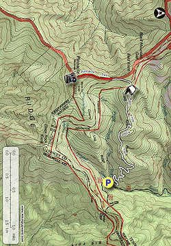
  • Mile 0.0 – The Bald Knob Ridge Trail [186] (white and yellow blaze) is located beside the bridge over Left Prong South Toe River. There is not much room to park, but this trail is isolated so it is likely not an issue. There is also a small parking area shortly up the road, on the other side of the bridge over Hemphill Creek. Begin the Bald Knob Ridge Trail, which is a well-maintained single-track trail that gently climbs the east slope of Bald Knob Ridge. You’ll follow many switchbacks through sparse hardwood forests.
  • Mile 1.3 – The trail levels out on Bald Knob Ridge heading west.
  • Mile 2.7 – Pass by campsites on the left side of the trail amidst tall conifers.
  • Mile 2.8 – The Bald Knob Ridge Trail ends at the Blue Ridge Parkway at milepost 355. Turn left and follow the parkway south.
  • Mile 3.0 – The obvious gated forest road on the right is the Old Mitchell Toll Road. You’ll see the beginning of the Pinnacle Trail (red blaze) on the right beyond the gate. The short but steep grass-lined summit trail passes through a magical variety of forests.
  • Mile 3.6 – The trail tops out at Pinnacle which features a series of open rock outcrops. First follow the trail to the east and take the right fork. The left fork is blazed and heads down the mountain. The right fork ends at a viewpoint. From here you can see Mackey Mountain and Green Knob east, with the South Mountains in the distance. To the south lie the Swannanoa Mountains and Hickory Nut Mountains. The large, round peak in the center is Bearwallow Mountain.

    Pinnacle, at 5,665 feet in elevation, is the tallest point of the Middle Mountain massif. The rock outcrops afford outstanding views south, west, and north. Graybeard Mountain is the prominent, round peak due south, with the smaller Rocky Knob in the foreground on the right. The Swannanoa Mountains are behind Graybeard Mountain and the Hickory Nut Mountains further south to the left. Towards the west the Great Craggy Mountains rise thousands of feet above the North Fork Swannanoa River. The tallest peak in the range, Craggy Dome, is in the center of your view, with Bullhead Mountain on the right and Craggy Gardens on the left. The Black Mountains dominant the view to the north. The tall, broad peak on the right is Mt. Mitchell. Clingmans Peak and Potato Knob are in the foreground, with the conical Blackstock Knob on the left.
  • Mile 6.9 – Hike ends at South Toe River Rd.
By HikingUpward Contributor: Zach Robbins
Explore 32 trails near Burnsville, NC

Know Before You Go

  • This 6.9-mile hike combines the Bald Knob Ridge Trail and a short section of the Pinnacle Trail, offering a gradual climb through diverse forests and a rewarding summit view.
  • While the Bald Knob Ridge Trail lacks significant viewpoints, adding the Pinnacle Trail provides access to panoramic vistas of the Great Craggy Mountains, Black Mountains, and surrounding peaks.
  • Seasonal closures of the South Toe River Road and Blue Ridge Parkway make access to the trailheads unlikely from November to March.
Interactive topographic map for Bald Knob Ridge to Pinnacle Hike located in Burnsville, NC. Click the "View Map" button to load GPS coordinates and trail markers.
Get directions
Distance
6.9 mi
Difficulty
Moderate
Type
Out-and-Back
Est. Time
3.5 hrs
Elev. Gain
1,890'
Rating
3.5
Added
March 13, 2025
Updated
April 05, 2025

Weather Forecast

Loading...
Total Change
1,753'
Ascent
1,890'
Descent
1,891'
Loading...

Download the GPX Data for Offline Use

Supporters get exclusive access to download trail routes to the MyHikes app for offline use. Stay prepared on your adventure, even without an internet connection! Become a Supporter today to unlock this feature and hike with confidence.

Download Bald Knob Ridge to Pinnacle Hike GPX Data to the MyHikes Mobile App

Features

Vista / Lookout Point
Dogs
Mountain Summit
Camping

Points of interest

  1. Parking

    35.711266, -82.250471
  2. Main Trailhead

    35.711256, -82.250412

Safety information

For your own safety: plan ahead, let someone know where you'll be, and hike at your own risk.

Hazards

Snakes (Rattlesnakes, Copperheads, others)
Poison Ivy or Poison Oak

Availability

All seasons

Surface type

Dirt

Trip Reports (Reviews)

Rated 3.5 out of 5 based on 2 ratings.

Ready to help fellow hikers? Add a trip report to share your experience and provide valuable insights for other hikers!

By: Zachary Robbins
6.9 miles / 11.1 km
October 05, 2019
I hiked this in one direction as part of a loop I was doing connecting the Buncombe Horse Range Trail via a long road walk on the BRP and NC 128. I don't recommend this loop, but I was knocking out both trails for the Black Mountains Hiking Challenge and it seemed ridiculous to have a shuttle. First I proceeded down the BHRT from the NC 128 crossing, and then walked up South Toe River Rd to connect with the Bald Knob Ridge Trail. I believe South Toe River Rd hasn't opened all year due to landslides. If you are planning to hike this, you will not be able to drive to the lower trailhead. You can park at the gate on the BRP and walk less than a mile down the forest road. The Bald Knob Ridge Trail was more overgrown than when I hiked it in 2017. But I hiked it in April, so what I experienced may be typical of growth after summer. It wasn't bad. I only noticed the weeds more because everything was wet from fog. Even though the entire area was covered in clouds I still hiked up to Pinnacle. The previous reviewer was correct. Someone took down the blazes going uphill, but did not take down all of the blazes looking downhill. However, the trail is really easy to follow so you should have no problems making it to the summit.
Legacy Review
By: Morgan M.
6.9 miles / 11.1 km
April 06, 2019
The Bald Knob Ridge portion was great. The access road was still closed, but there was room to park at the top. The road is somewhat steep down .7 miles, so add that in to your hiking plan. Additionally, the trailhead to Pinnacle is NO LONGER marked. Looks like the post was ripped out & the red trail marker is missing. There are no trail markers on trees going up the mountain, but there are several coming back down (???). The trailhead is immediately after the old gate though - pretty clearly on the right just after the gate.
Legacy Review
No community routes found. To add your own hike as a Community Route for this Trail guide, leave a Trip Report with an attached GPX file.

Popular categories

Scenic mountain view representing vista trails
Vista trails
Scenic gorge of cascades representing waterfall trails
Waterfall hikes
Rugged mountain terrain representing summit trails
Summit trails
Scenic mountain view representing dog-friendly trails
Dog-friendly
Scenic campsite with a view representing camping trails
Camping trails
Appalachian Trail logo representing A.T. hikes
A.T. hikes

You May Also Like

25 Best Day Hikes in North Carolina - Discover the top 25 best day hikes in North Carolina, from breathtaking waterfalls to mountain peaks. Explore hidden gems, scenic views, and trails suitable for all skill levels, perfect for your next outdoor adventure.
Explore

25 Best Day Hikes in North Carolina

Discover the top 25 best day hikes in North Carolina, from breathtaking waterfalls to mountain peaks. Explore hidden gems, scenic views, and trails suitable for all skill levels, perfect for your next outdoor adventure.

Read
Colorado's Million Dollar Highway - Plan a day's drive adventure along the iconic Million Dollar Highway in Colorado. Explore the best short trails, roadside stops, waterfalls, vistas, ghost towns, and hot springs within a ~6 hour road trip.
Explore

Colorado's Million Dollar Highway

Plan a day's drive adventure along the iconic Million Dollar Highway in Colorado. Explore the best short trails, roadside stops, waterfalls, vistas, ghost towns, and hot springs within a ~6 hour road trip.

Read
Glacier's Going-to-the-Sun Road - Discover the breathtaking beauty of Glacier National Park along the iconic Going-to-the-Sun Road. From stunning roadside stops to picturesque waterfalls and vistas, this engineering marvel offers endless opportunities for exploration.
Explore

Glacier's Going-to-the-Sun Road

Discover the breathtaking beauty of Glacier National Park along the iconic Going-to-the-Sun Road. From stunning roadside stops to picturesque waterfalls and vistas, this engineering marvel offers endless opportunities for exploration.

Read
🍪 We use cookies to learn about site usage and to serve map tiles. You may block cookies manually in the browser. By continuing you agree. Learn more