If you're hiking with very young children, or hikers who are just starting out and may not be in the best shape yet, you can also park on the ridge at the pink blazed Tower Trail, which makes for a very easy 10 minute walk to the tower with no elevation gain. Note: Tower Rd from VA758 is closed in the winter.
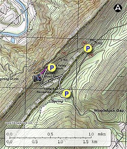
- Mile 0.0 - From the parking area in the Little Fort Camping/Recreation area start up the white blazed Wagon Rd/Nature Trail and in 0.1 miles cross the wide yellow 'V' blazed Peters Mill Run Trail. Be cautious, as the Peters Mill Run Trail is open to ATV's. The white blazed Wagon Rd/Nature Trail is one of the few trails in the Woodstock Gap area that is closed to motorized vehicles.
-
Mile 0.1 - After crossing the yellow 'V' blazed trail, continue on the white blazed trail as it becomes slightly steeper before making the first of two switchbacks in 0.1 miles. After the next switchback in another 0.3 miles, the trail is at it's steepest for the remaining 0.2 miles to the ridge and intersection of the pink blazed Tower Trail.
-
Mile 0.75 - Turn left on the pink blazed Tower Trail and follow it along the ridge for 150 yards to Woodstock Tower. Woodstock Tower is one of the few in GWNF where you are still permitted to climb to the observation deck.
- Mile 0.86 - Retrace your route back to the Little Fort Camping/Recreation area.