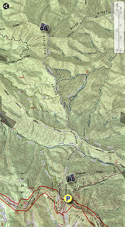
Take a trek along a remote section of the Mountains-to-Sea Trail (MST) in Pisgah National Forest. The MST follows the Woods Mountain Trail for 6 miles along this east-west massif. Woods Mountain is part of the area that constitutes the first purchase of national forest lands established on the east coast. Even though this was the first tract of Pisgah National Forest, this vast area from Armstrong Creek southwest to Jarrett Creek has largely been neglected by the forest service and hikers over the years. Many of the original trails have been abandoned or maintained infrequently compared to other regions. Much of this section has been designated an Inventoried Roadless Area and is being considered for Wilderness designation. It sure feels like wilderness when you leave the Blue Ridge Parkway on the Mountains-to-Sea Trail and follow the Woods Mountain Trail east. If not for the MST designation and blazes, one could get easily lost in this area since a vast network of forgotten trails crisscross the ridgelines. Casual hikers may want to check out the incredible view of the Armstrong Creek Valley 1.4 miles in and turn around. Beyond this view is a series of up-and-downs heading towards the former fire tower on Woods Mountain that is suitable for fit hikers and trail runners to experience.
- Mile 0.0 – At Buck Creek Gap on highway NC 80 park at the overlook below the Blue Ridge Parkway stone bridge. From the overlook is a nice view of the Buck Creek drainage and Singecat Ridge where you’ll be hiking shortly. Locate the service road access on the right side of the highway and follow that towards the parkway. You will pick up the Mountains-to-Sea Trail [440] (white blaze) when you meet the bridge. The MST parallels the parkway around a large bend along the service road track.
- Mile 0.7 – You’ll see double white blazes on a massive tree at a T-junction with the Woods Mountain Trail [218] (orange diamond blaze, only beyond Bad Fork Trail junction) at Hazelwood Gap. Turn right following the MST and Woods Mountain Trail along the steep shoulder of a ridge.
- Mile 1.0 – Y-junction with the Armstrong Creek Trail [223] (yellow blaze) on the left. Begin following a narrow ridge with gradually thinning trees as you climb towards Singecat Ridge.
- Mile 1.2 – Views west of Buck Creek Gap (you can probably see your car) and the dominant profile of the Black Mountains.
- Mile 1.3 – Wishbone junction with the Singecat Ridge Trail [unofficial] on the right beside multiple rebar posts. Shortly after this curve you’ll reach a Y-junction with the MST veering right. Turn left on this side path which leads to two overlooks on the left via two more side paths.
- Mile 1.4 – The first path on the left leads to an open bald spot with a sweeping view of the Armstrong Creek Valley over 1,300 feet below. This remote creek is a large tributary of the North Fork Catawba River. You can follow the stream course as it snakes east along the basin towards the river valley with the northern peaks of Linville Gorge beyond. On your left is a small window above Buck Creek Gap with a view of Balsam Cone, Cattail Peak, and Potato Hill. You can connect to the second viewing area via a short bushwhack through the scrub or head back down to the main side path and turn left. Note - This area has been periodically closed to protect endangered plant species, notably mountain golden heather. If it is closed you will see warning signs on the trees around the bald spot.
-
Mile 1.5 – Second view of the Armstrong Creek Valley. This view has less obstruction from trees and a better long-distance view of Roan Mountain and Grandfather Mountain. Retrace your steps to the MST.
Turn right on the MST and head west back towards the Blue Ridge Parkway if you are choosing to do the shortened version of this hike.
Turn left and head east on the MST to follow the full version of this hike to the summit of Woods Mountain.
- Mile 1.7 – Y-junction with an overgrown side trail to nowhere on the left. The trail begins a moderate descent through patches of old growth forest with some massive hardwood trees.
- Mile 2.4 – Four-way intersection with the Singecat Branch Trail [unofficial] on the right and a connector to the Armstrong Creek Trail on the left.
- Mile 2.6 – T-junction with an eroded path marked with flagging tape to Singecat Branch Trail. The MST begins climbing switchbacks to the Haines Eyebrow high point.
- Mile 2.9 – Wishbone junction with the Haines Eyebrow Trail [unofficial] on the right. On the Celo, NC USGS topo quad this high point is marked as Spruce Pine 6, a possible indicator that an antenna tower used to be located in the vicinity but there does not look to be any open viewpoints.
- Mile 3.3 – Y-junction with the Harris Creek Horse Trail [204] (yellow blaze) on the left.
- Mile 3.9 – Pass through a clearing, T-junction with the Rattlesnake Branch Trail [unofficial] on the right.
- Mile 4.4 – Y-junction with the Bad Fork Trail [227] (yellow blaze) on the left. You should turn around and take a mental picture of this intersection because the Bad Fork Trail has an orange diamond blaze on a brown national forest sign that confusingly says WOODS MTN. Half of the Woods Mountain Trail is open to equestrians and this may denote end of the horse path along the main MST/Woods Mt Trail as the horse trail may follow the Bad Fork Trail downhill. Beyond this junction you’ll start seeing orange diamond blazes for the Woods Mountain Trail.
- Mile 4.8 – A logged area offers decent camping opportunities. If you can find it there is a T-junction with the Little Buck Creek Trail [unofficial] somewhere on the right side of the clearing. The trail begins a steep climb up the west side of Woods Mountain.
- Mile 5.6 – On the left side of the trail is a view of the Armstrong Creek Valley and the Roan Highlands far north. You can barely see Hawksbill Mountain and Table Rock Mountain on the right.
- Mile 6.2 – At big right turn the MST continues south along Betsy Ridge. Instead of turning right look for an overgrown path leading east towards the Woods Mountain summit.
- Mile 6.4 – The overgrown path opens up as it makes a circle around the summit of Woods Mountain. You can check out the remains of an old lookout tower scattered around the summit. Two forest roads continue northeast and east downhill from the summit to connect with Armstrong Creek and Toms Creek respectively. Retrace your steps back to the Mountains-to-Sea Trail and head west back to the Blue Ridge Parkway.
- Mile 11.6 – Hike ends at Buck Creek Gap.