The Wolf Run Shoals hike starts on the upper end of the Occoquan
Reservoir, and is one of 4 hikes in the Bull Run and Occoquan trail
system along with Fountainhead Park (7.2 mls), Hemlock Overlook Park (3.8 mls), and Manassas Bull Run (5.3 mls). This out and back hike passes through several gullies on wide well maintained trails. The highlights include Wolf Run, partially obstructed views of the reservoir, and 2 small loop sections through older forest.
Wolf Run Shoals is also a historic landmark spanning several centuries. The link trail from the parking area is part of the Washington-Rochambeau revolutionary route of 1781. The Continental Army under the command of George Washington and Jean-Baptiste de Rochambeau marched from Newport Road, RI, to Yorktown VA along this path. During the American Civil War, both the Confederate and Union Armies considered Wolf Run Shoals a critical crossing point on the Occoquan River through 1863. In January 1863, the Vermont Brigade’s 12th and 13th infantry camped on the north side of the ford, with pickets being posted on the south side of the ford by the confederate troops from December 1861 until March 1862.
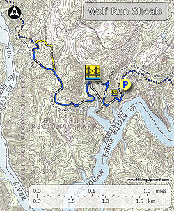
- Mile 0.0 – From the parking area at the end of Wolf Run Shoals Rd continue down the connector trail for 50 yards where the trail arrives at the intersection of the blue blazed Bull Run Occoquan Trail (BROT). Continue downhill on the BROT and the Occoquan Reservoir becomes visible through the trees. Make a hard right down through the gully and cross a bridge over a small creek.
- Mile 0.19 – After crossing the creek the blue blazed BROT will pass over another rise with views of the reservoir. Just past the high point arrive at a 4-way intersection.
- Mile 0.37 – Turn right staying on the blue blazed BROT where the trail is part of an old park road. Soon the BROT will make a sharp turn left of the old road downhill. Pass the BROT Mile 3 marker then arrive at a wooden footbridge and Wolf Run.
- Mile 0.79 – Cross Wolf Run where the trail turns left towards the reservoir through a flat wetland area. The trail will climbs over a ridge and becomes wider. Follow the trail through a small saddle past the Mile 4 marker and gently descend to the intersection of the yellow blazed trail. The yellow blazed trail is an original section of the BROT before it was rerouted to avoid passing close to a residential area.
- Mile 1.68 – Continue right on the yellow blazed trail where it shortly descends towards a white residential house. Follow the yellow blazed trail behind a shed and along the left side of a private driveway. You are very close to private property, so be careful to stay on the trail and not trespass. The yellow blazed trail then passes around the back of another private house before turning left off the wider trail and entering the woods. Follow the yellow blazes downhill for 0.2 miles back at the BROT.
- Mile 2.18 – Turn left on the blue blazed BROT passing through another small gully then steadily climbing back to the yellow blazed intersection you took earlier.
- Mile 2.6 – Stay straight on the blue blazed BROT retracing your steps past the Mile 4 marker, along the ridge, and back to the wooden footbridge crossing Wolf Run.
- Mile 3.64 – Immediately after crossing Wolf Run turn right on an unblazed trail that initially follows Wolf Run. The trail will climb towards the ridge and arrive at the 4-way intersection that you passed at Mile 0.37.
- Mile 3.89 – Continue straight at the 4-way intersection back onto the blue blazed BROT, re-crossing first stream, then climb up to the cut and parking area.
- Mile 4.3 – Arrive back at the parking area in Wolf Run Shoals Road.