The Wolf Run Lollipop Trail within the Wolf Run Wild Area at Tiadaghton State Forest near Cedar Run, Pennsylvania is a moderate 4-mile out-and-back hike that features overgrown mountain laurel and at least one obstructed seasonal view.
Trails
This hike follows an unmarked, unnamed trail that's the shape of a lollipop on the Wolf Run Wild Area map. Please note that as of December 2021, the lollipop portion of this trail no longer exists. The original goal was to hike this whole trail and explore the lollipop section, assuming there would be a vista along the mountain's edge; however, that section has become completely overgrown and no longer exists.
Hike Description
This hike begins along Barrens Road where the trailhead (41.463517, -77.423692) often takes a new hiker to this area several minutes to find it. As of December 2021, the easiest way to find this trail is to look for a large opening in the forest along the west side of the road -- if you see a space that looks to be 40-feet wide and about 60-feet heading downhill, the technical trailhead is located just north of there, but you can park there and claim it as the "new" trailhead.
After spending several minutes trying to find this trail, hikers will begin their hike by heading downhill toward a creek crossing - a tributary creek for Sebring Branch creek. First, they will pass through the large opening mentioned above, likely used as a turn-around spot for large trucks such as logging or mine trucks. Once at the creek crossing, the trail heads uphill along a steeper grade, but the climb does not last very long.
At the top of the mountain's plateau is where this trail flattens out, but then begins a long gradual descent. By the time the hiker has reached the top of the plateau, depending on current rainfall, they may be already covered in water because the mountain laurel overburden the trail and thus hikers will need to push through countless mountain laurel branches.
Lollipop Loop Begins - Mile 1.5
Around mile 1.5, hikers will reach - what looks like - the beginning of where the old lollipop section of this trail existed. We stayed to the right at this junction since the left-hand side seemed a bit overgrown anyway, hoping to come back to this spot after exploring the lollipop.
Overgrown Lollipop Continuation - Mile 1.95
Hikers will reach the approximate area for where the lollipop section would have continued around mile 1.95. Since I was with my small dog and my wife, we decided to head back shortly after accidentally hiking beyond where the lollipop section would have started, hence the extra mileage.
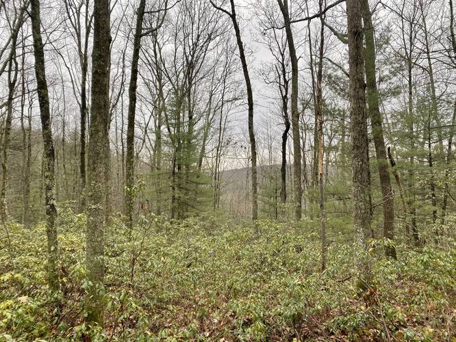
Obstructed Seasonal View - Mile 1.9
Around mile 1.9, hikers will also notice an obstructed seasonal view through the trees. It's nothing special, but the view exists only when leaves are gone.
After realizing the continuation of this trail was impassible, we decided to hike back the 2-miles to complete this hike for ~4-miles.
Please note that this overgrown, unmaintained, and unblazed trail continues on from where we stopped recording. It's possible that it leads to a vista or to nowhere! If you hike this, please leave a trip report with photos to help hikers in the future, thanks!
Parking
Hikers will find small parking turnouts along Barren Rd which runs adjacent to the Wolf Run Wild Area.
Pets
Dog are allowed and should be leashed so they don't get lost forever. Any dog waste should be carried out by the hiker.
Camping and Backpacking
While there were no campsites found along this trail, backpackers can certainly setup camp off-trail since there are plenty of small, but open spaces to setup a tent. Please follow all state forest backcountry / primitive / dispersed camping rules and regulations.
Blazes
This trail has no blazes or markers and has no official name. The trails within the Wolf Run Wild Area (with the exception of the Golden Eagle Trail and the Bob Webber Trail) are not maintained unless a generous hiker decides to clean them up.
Difficulty
This trail can be considered "Easy" for most hikers, except for the lack of trail blazes, unmaintained trail, in combination with the elevation grade - hence the "moderate" difficulty.
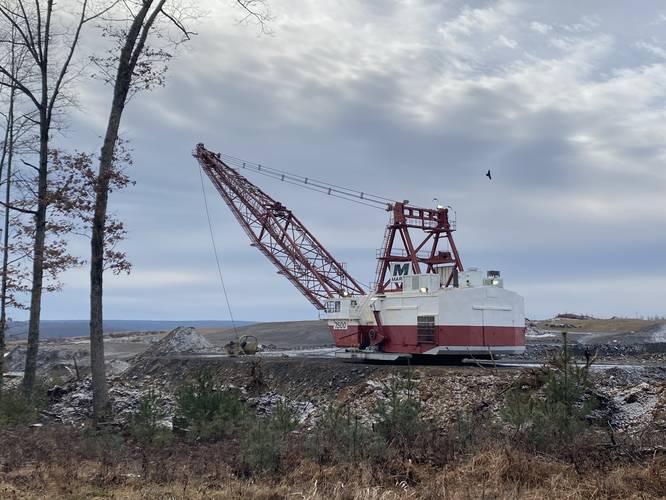
Driving to the Trailhead - Massive Coal Mine
Hikers might end up taking a driving route through State Game Lands 75 to reach this trailhead. Along the way is a massive open-pit coal mine with massive machines digging away at the earth. I've included a photo of this - if you zoom out on the map, you can see where the mine is located. Unfortunately this coal mine has devastated the mountain top... and is something that will likely never be reversed, meanwhile burning coal contributes insane amounts of carbon to our atmosphere... thanks PA!
Trails
This hike follows an unmarked, unnamed trail that's the shape of a lollipop on the Wolf Run Wild Area map. Please note that as of December 2021, the lollipop portion of this trail no longer exists. The original goal was to hike this whole trail and explore the lollipop section, assuming there would be a vista along the mountain's edge; however, that section has become completely overgrown and no longer exists.
Hike Description
This hike begins along Barrens Road where the trailhead (41.463517, -77.423692) often takes a new hiker to this area several minutes to find it. As of December 2021, the easiest way to find this trail is to look for a large opening in the forest along the west side of the road -- if you see a space that looks to be 40-feet wide and about 60-feet heading downhill, the technical trailhead is located just north of there, but you can park there and claim it as the "new" trailhead.
After spending several minutes trying to find this trail, hikers will begin their hike by heading downhill toward a creek crossing - a tributary creek for Sebring Branch creek. First, they will pass through the large opening mentioned above, likely used as a turn-around spot for large trucks such as logging or mine trucks. Once at the creek crossing, the trail heads uphill along a steeper grade, but the climb does not last very long.
At the top of the mountain's plateau is where this trail flattens out, but then begins a long gradual descent. By the time the hiker has reached the top of the plateau, depending on current rainfall, they may be already covered in water because the mountain laurel overburden the trail and thus hikers will need to push through countless mountain laurel branches.
Lollipop Loop Begins - Mile 1.5
Around mile 1.5, hikers will reach - what looks like - the beginning of where the old lollipop section of this trail existed. We stayed to the right at this junction since the left-hand side seemed a bit overgrown anyway, hoping to come back to this spot after exploring the lollipop.
Overgrown Lollipop Continuation - Mile 1.95
Hikers will reach the approximate area for where the lollipop section would have continued around mile 1.95. Since I was with my small dog and my wife, we decided to head back shortly after accidentally hiking beyond where the lollipop section would have started, hence the extra mileage.
Obstructed Seasonal View - Mile 1.9
Around mile 1.9, hikers will also notice an obstructed seasonal view through the trees. It's nothing special, but the view exists only when leaves are gone.
After realizing the continuation of this trail was impassible, we decided to hike back the 2-miles to complete this hike for ~4-miles.
Please note that this overgrown, unmaintained, and unblazed trail continues on from where we stopped recording. It's possible that it leads to a vista or to nowhere! If you hike this, please leave a trip report with photos to help hikers in the future, thanks!
Parking
Hikers will find small parking turnouts along Barren Rd which runs adjacent to the Wolf Run Wild Area.
Pets
Dog are allowed and should be leashed so they don't get lost forever. Any dog waste should be carried out by the hiker.
Camping and Backpacking
While there were no campsites found along this trail, backpackers can certainly setup camp off-trail since there are plenty of small, but open spaces to setup a tent. Please follow all state forest backcountry / primitive / dispersed camping rules and regulations.
Blazes
This trail has no blazes or markers and has no official name. The trails within the Wolf Run Wild Area (with the exception of the Golden Eagle Trail and the Bob Webber Trail) are not maintained unless a generous hiker decides to clean them up.
Difficulty
This trail can be considered "Easy" for most hikers, except for the lack of trail blazes, unmaintained trail, in combination with the elevation grade - hence the "moderate" difficulty.
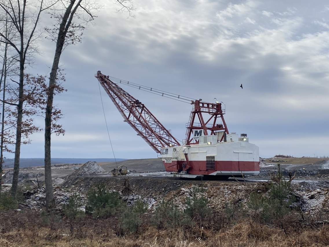
Driving to the Trailhead - Massive Coal Mine
Hikers might end up taking a driving route through State Game Lands 75 to reach this trailhead. Along the way is a massive open-pit coal mine with massive machines digging away at the earth. I've included a photo of this - if you zoom out on the map, you can see where the mine is located. Unfortunately this coal mine has devastated the mountain top... and is something that will likely never be reversed, meanwhile burning coal contributes insane amounts of carbon to our atmosphere... thanks PA!


