Loading...

🔥 End of Summer sale! 50% off on Supporter Accounts — now through September 1st. Learn More.

Wintergreen Hike

Directions
Map
Pictures
Send to App
Distance:
12.1 Miles / 19.5 km
Type:
Loop
Difficulty:
Strenuous
Time to Hike:
6 hours, ~5 minutes
Features:
Surface Type:
Dirt
Park:
George Washington National Forest
Town:
Wintergreen Resort, Virginia
Directions:
37.941271, -78.93644
Added:
February 17, 2025
Updated:
April 05, 2025
Guide by:
Copy Trail Link Hiking this trail? Send a friend or family member a link to this trail guide for your own safety. Hike at your own risk (disclaimer)
Loading...
Loading...
1,465'

Total Change
4,053'

Ascent
4,053'

Descent

Download the Trail Route for Offline Use

Supporters get exclusive access to download trail routes to the MyHikes app for offline use. Stay prepared on your adventure, even without an internet connection! Become a Supporter today to unlock this feature and hike with confidence.

Send to App

Wintergreen Hike

Wintergreen is known mainly for its ski slopes and resort facilities but did you know that it has over 30 miles of trails? The Wintergreen Nature Foundation maintains the trails and we were very impressed by how well they are maintained. They publish a map of all their trails which can be purchased from the WNF at the Trillium House.

This is actually a series of hikes that create one tough circuit with a ton of elevation change but you will be rewarded with many great overlooks and some beautiful waterfalls on the Upper Shamokin Falls trail a few miles from the end. This is the first really good circuit hike south of Shenandoah National Park. There is no camping allowed on the trail. A big thanks goes to frequent hikingupward.com reviewer BrandonB for the lead on these great trails at Wintergreen.

Some of the trails that make up the perimeter hike are closed from November to the end of March so before you go during that time period call the Wintergreen Nature Foundation (434-325-8169) for trail closings.
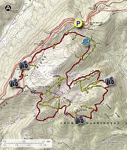
We began the hike at the Dripping Rock parking area on the Blue Ridge Parkway. Head North on the White-blazed A.T for about 150 yards and bear to the right on an unmarked trail (rock cairn). Stay on the trail for 0.1 miles crossing Laurel Springs Drive. On the other side of the road the yellow blazed Old Appalachian Trail begins. You will begin to see some of the Wintergreen homes to the right and left. In 0.3 miles you will pass the Upper Shamokin Gorge Trail on the left, stay on the Old A.T. which at this point becomes red-blazed. You will see and hear Stoney Creek on your left. In 0.4 miles the Nature Preserve Loop will be on your left and in another 0.3 miles you will cross Laurel Springs Drive again.

The first of many great views looking west towards Sherando and Torry Ridge will be 0.6 miles after crossing the road. Just after that first view is the Laurel Springs Drive Access Trail on the left. The next 0.7 miles will have multiple views and the Hemlock Drive Access trail on the left, stay on the Old A.T.

The next 0.5 miles is quite challenging with the Old AT ending at Cedar Road. Take a left onto Cedar Road for 0.1 miles then a right onto Devil's Knob Loop for 0.2 miles, reaching the Blue Ridge Overlook (N37 54.944 W78 57.509) & Parking area. This could be an alternate starting point if you are spending the weekend at Wintergreen. The Devil's Knob Trail (red blazes) begins at the right side of the parking lot and begins the steady descent to Fortunes Ridge. Stay on the Devil's Knob Trail for 0.4 miles to the Pond Hollow Trail intersection, bear right onto the Pond Hollow Trail, red blazed. The next intersection is in 0.4 miles on the left, Pond Hollow Crossover. Stay straight and in 0.5 miles cross over Wintergreen Drive (be very careful) walking on the side of the road for about 100 yards towards Fortunes Ridge Drive. The Fortunes Ridge Trail begins just on the other side of Fortunes Ridge Drive.

The Laurel Ridge Loop intersection is in 0.8 miles, bear to the right staying on the Fortunes Ridge Trail heading to the Three Ridges Overlook/Brimstone Trail intersection which you will reach in 0.5 miles. Bear to the right onto the Brimstone Trail (this section has many great views of Three Ridges) heading to The Plunge trail in 0.7 miles. If you have time, take The Plunge trail (yellow blazes) to see a great overlook, well worth the short side trip. If not, bear right onto the Blackrock Trail for 0.7 miles until the Blackrock Circle access trail, bear right onto the Pedlars Edge Trail. From this point on until the end of the hike there will not be very many views but hang in there because if the water is flowing, the Shamokin Falls will be worth it at the end of the Logger's Alley trail.

On the Pedlar's Edge Trail go 0.3 miles and turn onto a gravel fire road. In 0.2 miles look for a Yellow & Red Arrow sign on the left, turn left onto the trail. You will pass underneath and alongside a Power Line in 0.5 miles and then making a sharp turn to the right in 0.1 miles onto a dirt road, staying on the Pedlar's Edge Trail. Take a left in 0.1 miles continuing on the Pedlar's Edge Trail. In 0.2 miles there is one of the rare views on this part of the trail looking over to Cedar Cliffs. Just after the view and over the next 0.1 miles are a couple of intersection signs, stay on the Pedlar's Edge Trail for both of them. The third sign you come to will lead you across Stony Creek to the Hemlock Springs Trail/Hemlock Springs Loop (one tree has 3 red blazes at this crossing). Stony Creek was flowing pretty well so we had to go downstream a little to find a suitable crossing.

Soon after crossing Stony Creek you will come to the Intersection of the Hemlock Springs Loop, stay straight heading to Cedar Cliffs South. In 0.2 miles turn left onto Cedar Cliffs Main trail (there are misleading trail markings on the back of this sign which you will see first before you turn left, ignore them). Within 100' quickly turn right at the next intersection onto the Cedar Cliffs North trail. This is a very tough part of the trail ending at the Logger's Alley Trail in 1 mile. Turn right onto Logger's Alley Trail just after passing the Outdoors Ropes Course area. There was no sign to turn right as it disappeared over the winter. You will cross 3-4 of Wintergreen's ski slopes which accounts for some of the trail closings in the winter.

It is about 0.4 miles to cross all the ski slopes and then you will be on an old logging road with very few faded red blazes. Logger's Alley was our least favorite part of the trail. You will also see occasional blue 'Intermediate' signs and 1 mile after crossing the slopes you will see a red and white sign that says '1.5 Miles'. In 0.2 miles after that sign you will be rewarded with the 1st of the Upper Shamokin Falls. It was flowing well in April when we were there. After viewing the Falls return to the intersection sign just before the Falls and head up towards the Upper Shamokin Falls trail and in 0.1 miles you will be see a 2nd set of Falls, this is even better than the first. Continue up the trail heading to the Upper Shamokin Gorge trail. On the right in 0.2 miles will be the Laurel Springs Drive access trail, stay straight heading to the Shamokin Gorge trail. The Chestnut Springs Trail will be on the left in 0.1 miles, stay straight, the sign will point to Laurel Springs Gap Overlook which will be in 0.1 miles. Stay on the Upper Shamokin Gorge Trail arriving at the Old A.T. trail in 0.4 miles, turn right and cross Laurel Springs Drive in 0.3 miles reaching the A.T. intersection in 0.1 miles. Turn left to return to the Dripping Rock Parking Area.

Explore 37 trails near Wintergreen Resort, VA
  1. Parking

    37.941271, -78.93644
  2. Main Trailhead

    37.941185, -78.936596
No community routes found. To add your own hike as a Community Route for this Trail guide, leave a Trip Report with an attached GPX file.

Hazards

Ticks - Lyme Disease More Info (CDC)
Snakes
Poison Ivy/Oak

Seasons

All

Blaze Color

White

Photo Albums

+ Add Photo Album

Upload your photos from the trail to help others know what to expect.

Trip Reports (Reviews)

Rated 2.89 out of 5 based on 9 ratings.
By: Justin
12.1 miles / 19.5 km
September 15, 2019
Do not take the difficulty rating lightly! This might be the most difficult circuit I have hiked in this area and I consider myself to be in pretty good shape. I have hiked many of the hikes on this site in 1/2 or 2/3 of the recommended time, but this hike took just about 8 hours as listed. The elevation change on this hike is brutal and wet rocks can make it more challenging. There were some cool sights, but I was too cooked to enjoy them by the end. As many others have mentioned, it is definitely worth picking up a map of the area before you proceed with the hike. I relied solely on these directions and paid for it with some confusion, as some of these directions may be outdated. On the Pedlar's trail section, I missed the turn on the gravel fire road and the following red & yellow sign, so I was just on Pedlar's trail until I reached the power line. After you have reached the last sign on Pedlar's trail, be sure to cross the stream and do not follow the road. It is not immediately obvious where one should cross the creek by looking at that sign, but there is another sign on the opposite side of the road.
Legacy Review
By: Jay
12.1 miles / 19.5 km
November 22, 2018
I hiked around 9 miles of the circuit on Thanksgiving Day and earned my calories! I was staying at the Mountain Inn so I started at the Logger's Alley section. Instead of turning left at the Chestnut Springs intersection, I stayed on Logger's Alley to the bottom of the Shamokin Springs Falls and then followed the Upper Shamokin Falls trail. While the Logger's Alley section was fairly tame, the journey up the falls is quite steep and rocky. From there I followed the circuit around to mid-way through the Pond Hollow trail. An ice storm the previous week had downed lots of trees on the western portion and it wasn't fun anymore so I used the Laurel Ridge trail to return to the Inn. All in all, it's a good, challenging hike and I plan to return to it in Spring in hope that the trial is mostly clear of downed trees. One item of note, it appears that the trail blazes were repainted fairly recently as they were easily spotted. However, some signage is still confusing or easy to miss.
Legacy Review
By: Charlie
12.1 miles / 19.5 km
June 30, 2017
This is a lovely loop and challenging only really in its length and elevation gain ~(our GPS tracker had us at 15 miles - I think the map he's used has 'straightened the curves' when calculating the distance). I should warn you though that through a combination of some changes to the signage and the fact that the original guide is pretty unclear at times, its worth mapping this out properly in advance, especially if conditions aren't clear. There are some scrambling sections but its no way as fierce as some reviewers have suggested and to be fair to the original poster, he has given the trail a 6 out of 5! There is lovely variety throughout and the mixture of terrain, undulations in the landscape, stunning overlooks and aspects and striking rock formations make this a very rewarding loop. The final couple of miles up the gorge are actually some of the prettiest but unless you're fit you won't be in much shape to enjoy it. We did it in around seven hours with a couple of short breaks as we were chasing the light after a late start but I'd recommend getting on the trail pretty early and taking plenty of food and drink and enjoying it at a slower pace. I wish I'd taken a notepad to make detailed corrections to the original guide that I could re-post as there are now several errors and much of the guide could use a refresh. We even met a bear! Enjoy.
Legacy Review

Weather Forecast

In Wintergreen Resort, VA

Explore Hiking Trails

You May Also Like

New York's Best Waterfalls - Whether you're planning a day hike, roadside stop, or a leisurely short walk, this guide provides hikers, travelers, and locals alike with 63 different locations to over 100 scenic waterfalls to help plan your next adventure!
Explore

New York's Best Waterfalls

Whether you're planning a day hike, roadside stop, or a leisurely short walk, this guide provides hikers, travelers, and locals alike with 63 different locations to over 100 scenic waterfalls to help plan your next adventure!

Read
25 Best Day Hikes in North Carolina - Discover the top 25 best day hikes in North Carolina, from breathtaking waterfalls to mountain peaks. Explore hidden gems, scenic views, and trails suitable for all skill levels, perfect for your next outdoor adventure.
Explore

25 Best Day Hikes in North Carolina

Discover the top 25 best day hikes in North Carolina, from breathtaking waterfalls to mountain peaks. Explore hidden gems, scenic views, and trails suitable for all skill levels, perfect for your next outdoor adventure.

Read

Before you boogie...

Find our trail guides useful? Consider becoming a Supporter to unlock perks!

MyHikes is an indie platform that makes exploring public trails easier for everyone. The platform has no investors, no ads, and is owned and operated by one person, Dave Miller. Dave has personally mapped and written over 1,800 trail guides on MyHikes for the public to explore. MyHikes has helped millions outdoor enthusiasts plan their next adventure.

But it takes a lot of time 🕦, money 💰, work, and espresso shots ☕ to run MyHikes, including hiking , mapping , writing , and publishing new trails with high-quality (accurate) information... along with software engineering (coding) the platform like building new features, website and mobile app development (iOS and Android), site maintainance . and much much more.

Supporters unlock website and mobile app perks with an annual one-time payment of $25 (you renew) 😎👍. Or you can simply make a Donation of your choice. Otherwise, you can support us by telling your friends about MyHikes - both quick and free 🎉

Admin user profile picture

Dave Miller
MyHikes Founder