Loading...

๐ŸŽ‰ Enjoy a Free 7-Day Supporter Trial and Unlock Exclusive Perks โ€” No Credit Card Required. Learn more.

Whiting Peak via Metacoment-Monadnock Trail

Directions
Map
Pictures
Send to App
Distance:
1.5 Miles / 2.4 km
Type:
Out-and-Back
Difficulty:
Moderate
Time to Hike:
~45 minutes
Features:
Surface Type:
Dirt
Park:
Mount Tom State Reservation
Town:
Holyoke, Massachusetts
Directions:
42.264648, -72.638558
Added:
June 20, 2019
Updated:
July 31, 2019
Copy Trail Link Hiking this trail? Send a friend or family member a link to this trail guide for your own safety. Hike at your own risk (disclaimer)
Loading...
Loading...
404'

Total Change
496'

Ascent
496'

Descent

Download the Trail Route for Offline Use

Supporters get exclusive access to download trail routes to the MyHikes app for offline use. Stay prepared on your adventure, even without an internet connection! Become a Supporter today to unlock this feature and hike with confidence.

Send to App

Whiting Peak via Metacoment-Monadnock Trail

Whiting Peak via Metacoment-Monadnock Trail at Mount Tom State Reservation in Holyoke, Massachusetts is a moderate 1.5-mile out-and-back hike up to a lookout point, just below Whiting Peak.

The trail starts off by following white blazes to a small field near a maintenance shed. Take the right-most trailhead on the other side of the field and continue to follow white blazes (M & M Trail) to the summit.

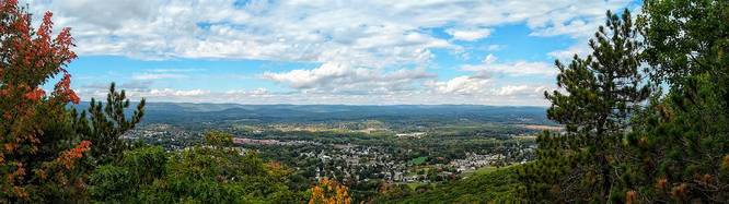
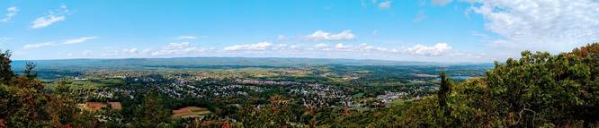
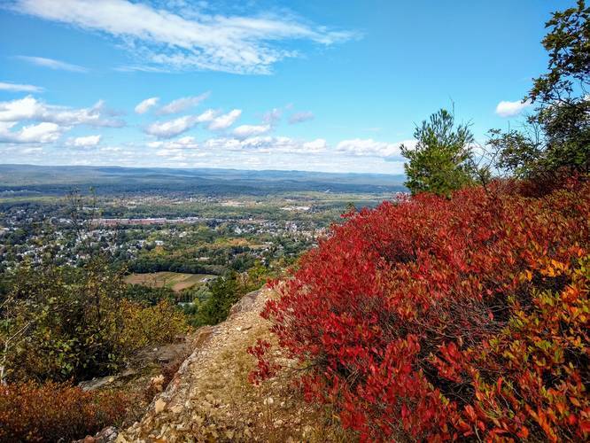
The trail is steep and unrelenting for the first 0.4-miles, but the elevation soon eases and offers many vista points above Easthampton, MA along with views of Mt Tom as well. Follow the trail along the cliff edges on the Metacoment - Monadnock Trail (white blazes) until you reach Whiting Peak roughly 0.75 miles from the parking lot.

Deadtop is roughly 0.4-miles further and the Mt Tom summit is 1.3 miles from Whiting Peak. Hike south along the M & M Trail from Whiting Peak to complete the southern portion of the Mt Tom Traverse.

Parking: Parking is available just off Reservation Road, at the coordinates provided, beyond the Stone Crusher.

Pets: Dogs are allowed if leashed and their waste must be carried out by the hiker.
Explore 207 trails near Holyoke, MA
  1. Parking

    42.264648, -72.638558
  2. Main Trailhead

    42.264648, -72.638558
  3. View / Overlook / Vista

    42.261111, -72.639722
    View / Overlook / Vista
  4. View / Overlook / Vista

    42.260278, -72.640278
    View / Overlook / Vista
  5. Vista

    42.253807, -72.644418
    Vista
Explore other routes for this Trail guide, added by the MyHikes' community via Trip Reports. To add your own hike as a Community Route for this Trail guide, leave a Trip Report with an attached GPX file.

Hazards

Ticks - Lyme Disease More Info (CDC)
Snakes

Seasons

All

Blaze Dot

White

Trip Reports

Trail Guide By:
Tocra user profile picture
1.5 miles / 2.4 km
2.8 miles / 4.5 km
November 11, 2023
Whiting Peak and Dead Top. Conditions are a little slippery from all the fallen leaves, but the views from both peaks are gorgeous as ever.
Hiking
2.0 miles / 3.2 km
October 01, 2020

Weather Forecast

In Holyoke, MA

Explore Hiking Trails

You May Also Like

Colorado's Million Dollar Highway - Plan a day's drive adventure along the iconic Million Dollar Highway in Colorado. Explore the best short trails, roadside stops, waterfalls, vistas, ghost towns, and hot springs within a ~6 hour road trip.
Explore

Colorado's Million Dollar Highway

Plan a day's drive adventure along the iconic Million Dollar Highway in Colorado. Explore the best short trails, roadside stops, waterfalls, vistas, ghost towns, and hot springs within a ~6 hour road trip.

Read
Glacier's Going-to-the-Sun Road - Discover the breathtaking beauty of Glacier National Park along the iconic Going-to-the-Sun Road. From stunning roadside stops to picturesque waterfalls and vistas, this engineering marvel offers endless opportunities for exploration.
Explore

Glacier's Going-to-the-Sun Road

Discover the breathtaking beauty of Glacier National Park along the iconic Going-to-the-Sun Road. From stunning roadside stops to picturesque waterfalls and vistas, this engineering marvel offers endless opportunities for exploration.

Read
New York's Best Waterfalls - Whether you're planning a day hike, roadside stop, or a leisurely short walk, this guide provides hikers, travelers, and locals alike with 63 different locations to over 100 scenic waterfalls to help plan your next adventure!
Explore

New York's Best Waterfalls

Whether you're planning a day hike, roadside stop, or a leisurely short walk, this guide provides hikers, travelers, and locals alike with 63 different locations to over 100 scenic waterfalls to help plan your next adventure!

Read

Before you boogie...

Find our trail guides useful? Consider becoming a Supporter to unlock perks!

MyHikes is an indie platform that makes exploring public trails easier for everyone. The platform has no investors, no ads, and is owned and operated by one person, Dave Miller. Dave has personally mapped and written over 1,800 trail guides on MyHikes for the public to explore. MyHikes has helped millions outdoor enthusiasts plan their next adventure.

But it takes a lot of time ๐Ÿ•ฆ, money ๐Ÿ’ฐ, work, and espresso shots โ˜• to run MyHikes, including hiking , mapping , writing , and publishing new trails with high-quality (accurate) information... along with software engineering (coding) the platform like building new features, website and mobile app development (iOS and Android), site maintainance . and much much more.

Supporters unlock website and mobile app perks with an annual one-time payment of $25 (you renew) ๐Ÿ˜Ž๐Ÿ‘. Or you can simply make a Donation of your choice. Otherwise, you can support us by telling your friends about MyHikes - both quick and free ๐ŸŽ‰

Admin user profile picture

Dave Miller
MyHikes Founder