Loading...

๐ŸŽ‰ Enjoy a Free 7-Day Supporter Trial and Unlock Exclusive Perks โ€” No Credit Card Required. Learn more.

Mt Tom Traverse

Directions
Map
Pictures
Send to App
Distance:
4.8 Miles / 7.7 km
Type:
One-Way
Difficulty:
Moderate
Time to Hike:
2 hours, ~24 minutes
Features:
Surface Type:
Dirt
Park:
Mount Tom State Reservation
Town:
Holyoke, Massachusetts
Directions:
42.236089, -72.651195
Added:
March 26, 2018
Updated:
September 12, 2019
Copy Trail Link Hiking this trail? Send a friend or family member a link to this trail guide for your own safety. Hike at your own risk (disclaimer)
Loading...
Loading...
1,063'

Total Change
882'

Ascent
1,153'

Descent

Download the Trail Route for Offline Use

Supporters get exclusive access to download trail routes to the MyHikes app for offline use. Stay prepared on your adventure, even without an internet connection! Become a Supporter today to unlock this feature and hike with confidence.

Send to App

Mt Tom Traverse

This recording is of the southern portion of the Mt Tom Traverse which follows the M & M Trail through the park. It also includes a portion of Reservation road from the northern trailhead to the exit of the park on Route 5.

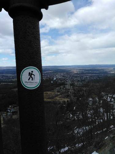
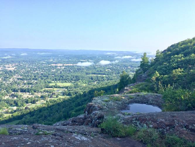
The trail is highly trafficked but offers many views along the way. It starts off with a very steep but short climb up Mt Tom. From the summit you can see Springfield, Barnes Airbase, Westover Air Force Base, and Easthampton.

Following along the white blazes north, the trail skirts along tall cliffs peering down on Easthampton and the Route 141 entrance to the park. During the winter months it can get very icy on trail and during this recording it was very slick and muddy, ice spikes are highly recommended. The trail breaks on Reservation Rd where you can choose to turn back or continue on to Goat Peak and the Eyrie House Ruins.

Distance: The trail is only 2.6 miles one-way from the southern trailhead to the northern trailhead along Reservation Road. If you want to hike this out-and-back, you can plan for about 5 to 6 miles total depending on how far you continue along the M & M Trail beyond the northern trailhead.
Explore 207 trails near Holyoke, MA
  1. Parking

    42.236089, -72.651195
  2. Main Trailhead

    42.235956, -72.650932
  3. Summit vista point

    42.241667, -72.648056
    Summit vista point
  4. View along the ridge of Mount Tom

    42.247033, -72.647172
    View along the ridge of Mount Tom
Explore other routes for this Trail guide, added by the MyHikes' community via Trip Reports. To add your own hike as a Community Route for this Trail guide, leave a Trip Report with an attached GPX file.

Hazards

Ticks - Lyme Disease More Info (CDC)

Seasons

All

Blaze Dot

White

Trip Reports

Trail Guide By:
Tocra user profile picture
4.8 miles / 7.7 km
1.9 miles / 3.1 km
August 05, 2018
Hiked up to the DOC Trail junction.
Hiking
4.8 miles / 7.7 km
August 05, 2018

Weather Forecast

In Holyoke, MA

Explore Hiking Trails

You May Also Like

Colorado's Million Dollar Highway - Plan a day's drive adventure along the iconic Million Dollar Highway in Colorado. Explore the best short trails, roadside stops, waterfalls, vistas, ghost towns, and hot springs within a ~6 hour road trip.
Explore

Colorado's Million Dollar Highway

Plan a day's drive adventure along the iconic Million Dollar Highway in Colorado. Explore the best short trails, roadside stops, waterfalls, vistas, ghost towns, and hot springs within a ~6 hour road trip.

Read
Glacier's Going-to-the-Sun Road - Discover the breathtaking beauty of Glacier National Park along the iconic Going-to-the-Sun Road. From stunning roadside stops to picturesque waterfalls and vistas, this engineering marvel offers endless opportunities for exploration.
Explore

Glacier's Going-to-the-Sun Road

Discover the breathtaking beauty of Glacier National Park along the iconic Going-to-the-Sun Road. From stunning roadside stops to picturesque waterfalls and vistas, this engineering marvel offers endless opportunities for exploration.

Read
New York's Best Waterfalls - Whether you're planning a day hike, roadside stop, or a leisurely short walk, this guide provides hikers, travelers, and locals alike with 63 different locations to over 100 scenic waterfalls to help plan your next adventure!
Explore

New York's Best Waterfalls

Whether you're planning a day hike, roadside stop, or a leisurely short walk, this guide provides hikers, travelers, and locals alike with 63 different locations to over 100 scenic waterfalls to help plan your next adventure!

Read

Before you boogie...

Find our trail guides useful? Consider becoming a Supporter to unlock perks!

MyHikes is an indie platform that makes exploring public trails easier for everyone. The platform has no investors, no ads, and is owned and operated by one person, Dave Miller. Dave has personally mapped and written over 1,800 trail guides on MyHikes for the public to explore. MyHikes has helped millions outdoor enthusiasts plan their next adventure.

But it takes a lot of time ๐Ÿ•ฆ, money ๐Ÿ’ฐ, work, and espresso shots โ˜• to run MyHikes, including hiking , mapping , writing , and publishing new trails with high-quality (accurate) information... along with software engineering (coding) the platform like building new features, website and mobile app development (iOS and Android), site maintainance . and much much more.

Supporters unlock website and mobile app perks with an annual one-time payment of $25 (you renew) ๐Ÿ˜Ž๐Ÿ‘. Or you can simply make a Donation of your choice. Otherwise, you can support us by telling your friends about MyHikes - both quick and free ๐ŸŽ‰

Admin user profile picture

Dave Miller
MyHikes Founder