Loading...

🎆 50% off 4th of July sale on Supporter Accounts — now through July 6! Learn More.

White Trail (The Gully Preserve)

Directions
Map
Pictures
Send to App
Distance:
0.3 Miles / 0.5 km
Type:
Out-and-Back
Difficulty:
Moderate
Time to Hike:
~9 minutes
Features:
Surface Type:
Dirt
Park:
The Gully Preserve
Town:
Wayland, New York
Directions:
42.557074, -77.65212
Added:
May 14, 2023
Updated:
May 18, 2023
Copy Trail Link Hiking this trail? Send a friend or family member a link to this trail guide for your own safety. Hike at your own risk (disclaimer)
Loading...
Loading...
73'

Total Change
75'

Ascent
75'

Descent

Download the Trail Route for Offline Use

Supporters get exclusive access to download trail routes to the MyHikes app for offline use. Stay prepared on your adventure, even without an internet connection! Become a Supporter today to unlock this feature and hike with confidence.

Send to App

White Trail (The Gully Preserve)

The White Trail at The Gully Preserve in Wayland, New York is a moderate 0.3-mile out-and-back hike that leads along the top of the Little Mill Creek gorge with obstructed views of several waterfalls.

Hike Description
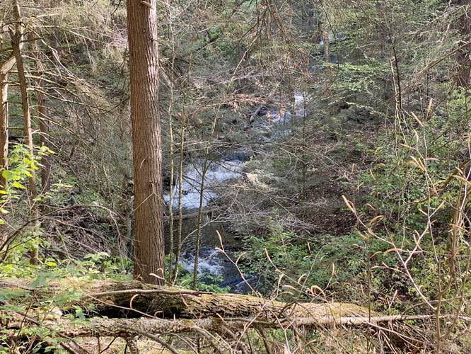
This hike begins along the northern side of Whiteman Gully Road at the white blazed trail sign. Hikers will follow this trail uphill for the entire way until they reach a dead end. Along the way you can hear the rushing water of the many waterfalls that cascade down Little Mill Creek below - including Flume Gully Falls. Although most of the waterfalls are obstructed by tree branches and leaves, hikers still get a beautiful hike along this trail. As of May 2023, there were several blowdown trees located just before the signage for private property - where the trail ends. There, hikers can get a "decent", but obstructed view, looking up another portion of Little Mill Creek.

Parking
Hikers will find two very small parking turnouts just west of the trailhead along Whiteman Gully Road. The turnouts are large enough to fit about 3 vehicles each, max.

Pets
Dogs are allowed only if leashed and cleaned up after.
Explore 20 trails near Wayland, NY
  1. Parking

    42.557074, -77.65212
  2. Main Trailhead

    42.557208, -77.651707
  3. Obstructed view of waterfalls in Little Mill Creek

    42.558922, -77.652253
    Obstructed view of waterfalls in Little Mill Creek
No community routes found. To add your own hike as a Community Route for this Trail guide, leave a Trip Report with an attached GPX file.

Hazards

Ticks - Lyme Disease More Info (CDC)
Poison Ivy/Oak

Seasons

All

Blaze Color

White

Weather Forecast

In Wayland, NY

Explore Hiking Trails

You May Also Like

Colorado's Million Dollar Highway - Plan a day's drive adventure along the iconic Million Dollar Highway in Colorado. Explore the best short trails, roadside stops, waterfalls, vistas, ghost towns, and hot springs within a ~6 hour road trip.
Explore

Colorado's Million Dollar Highway

Plan a day's drive adventure along the iconic Million Dollar Highway in Colorado. Explore the best short trails, roadside stops, waterfalls, vistas, ghost towns, and hot springs within a ~6 hour road trip.

Read
Glacier's Going-to-the-Sun Road - Discover the breathtaking beauty of Glacier National Park along the iconic Going-to-the-Sun Road. From stunning roadside stops to picturesque waterfalls and vistas, this engineering marvel offers endless opportunities for exploration.
Explore

Glacier's Going-to-the-Sun Road

Discover the breathtaking beauty of Glacier National Park along the iconic Going-to-the-Sun Road. From stunning roadside stops to picturesque waterfalls and vistas, this engineering marvel offers endless opportunities for exploration.

Read
New York's Best Waterfalls - Whether you're planning a day hike, roadside stop, or a leisurely short walk, this guide provides hikers, travelers, and locals alike with 63 different locations to over 100 scenic waterfalls to help plan your next adventure!
Explore

New York's Best Waterfalls

Whether you're planning a day hike, roadside stop, or a leisurely short walk, this guide provides hikers, travelers, and locals alike with 63 different locations to over 100 scenic waterfalls to help plan your next adventure!

Read

Before you boogie...

Find our trail guides useful? Consider becoming a Supporter to unlock perks!

MyHikes is an indie platform that makes exploring public trails easier for everyone. The platform has no investors, no ads, and is owned and operated by one person, Dave Miller. Dave has personally mapped and written over 1,800 trail guides on MyHikes for the public to explore. MyHikes has helped millions outdoor enthusiasts plan their next adventure.

But it takes a lot of time 🕦, money 💰, work, and espresso shots ☕ to run MyHikes, including hiking , mapping , writing , and publishing new trails with high-quality (accurate) information... along with software engineering (coding) the platform like building new features, website and mobile app development (iOS and Android), site maintainance . and much much more.

Supporters unlock website and mobile app perks with an annual one-time payment of $25 (you renew) 😎👍. Or you can simply make a Donation of your choice. Otherwise, you can support us by telling your friends about MyHikes - both quick and free 🎉

Admin user profile picture

Dave Miller
MyHikes Founder