Flume Gully Falls at The Gully Preserve in Wayland, New York is an easy 0.2-mile out-and-back hike that leads to a series of waterfalls that cascades down a rock flume gorge. Flume Gully Falls.
Waterfalls
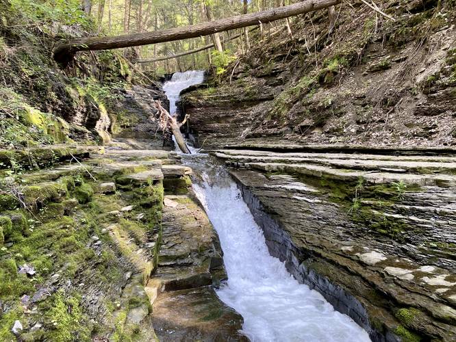
This hike leads to a multi-tiered waterfall named Flume Gully Falls. The largest cascade is about 10-feet tall with lower cascades of about 5+ feet tall that shoot down a naturally carved out rock flume. There are many other waterfalls upstream to the last waterfall in this hike, but they're all inaccessible due to the steep surrounding gorge terrain. Most of them are visible, obstructed, via the White Trail at The Gully Preserve.
Hike Description
This hike begins along the White Trail at The Gully Preserve, almost immediately to the right-hand side of the trail once you hop on the White Trail. Hikers will head down a small hillside and then meander through the forest, adjacent to Little Mill Creek, as this unofficial trail makes its way over to the waterfalls.
Around mile 0.1, hikers will locate the rock flume and its waterfalls as they cascade down the creek's bedrock. The lower portion of the waterfalls is fairly easy to navigate as the bedrock surrounding the flume is mostly flat; however, you must be careful if you choose to make your way up the creek further. Hikers will have to carefully walk along the flat sections of shale bedrock to make their way up the waterfalls until they reach an inaccessible point where you can't hike any further. Here, you get a beautiful view of a ~10-foot waterfall located upstream, with a nice pool of water that sits calmly between the large waterfall's lower slide and the rock flume below. This is a great spot for fishing as well.
Parking
Hikers will find two very small parking turnouts just west of the trailhead along Whiteman Gully Road. The turnouts are large enough to fit about 3 vehicles each, max.
Pets
Dogs are allowed only if leashed and cleaned up after.
Warning
Slippery rocks / flume: In order to explore this waterfall, hikers must walk adjacent to fast moving water that rockets through a bedrock rock flume. Watch every step as you could get seriously injured if you accidentally fall in.
Waterfalls
This hike leads to a multi-tiered waterfall named Flume Gully Falls. The largest cascade is about 10-feet tall with lower cascades of about 5+ feet tall that shoot down a naturally carved out rock flume. There are many other waterfalls upstream to the last waterfall in this hike, but they're all inaccessible due to the steep surrounding gorge terrain. Most of them are visible, obstructed, via the White Trail at The Gully Preserve.
Hike Description
This hike begins along the White Trail at The Gully Preserve, almost immediately to the right-hand side of the trail once you hop on the White Trail. Hikers will head down a small hillside and then meander through the forest, adjacent to Little Mill Creek, as this unofficial trail makes its way over to the waterfalls.
Around mile 0.1, hikers will locate the rock flume and its waterfalls as they cascade down the creek's bedrock. The lower portion of the waterfalls is fairly easy to navigate as the bedrock surrounding the flume is mostly flat; however, you must be careful if you choose to make your way up the creek further. Hikers will have to carefully walk along the flat sections of shale bedrock to make their way up the waterfalls until they reach an inaccessible point where you can't hike any further. Here, you get a beautiful view of a ~10-foot waterfall located upstream, with a nice pool of water that sits calmly between the large waterfall's lower slide and the rock flume below. This is a great spot for fishing as well.
Parking
Hikers will find two very small parking turnouts just west of the trailhead along Whiteman Gully Road. The turnouts are large enough to fit about 3 vehicles each, max.
Pets
Dogs are allowed only if leashed and cleaned up after.
Warning
Slippery rocks / flume: In order to explore this waterfall, hikers must walk adjacent to fast moving water that rockets through a bedrock rock flume. Watch every step as you could get seriously injured if you accidentally fall in.