-
Mile 0.0 – Start (from the lower parking area) by hiking uphill on the forestry service road (FS) for 0.3 miles where you will reach a closed gate and additional parking for five vehicles.
-
Mile 0.3 – Pass the closed gate and continue on the orange blazed FS road for 0.25 miles to the intersection of the pink blazed Old Mail Path on the right.
-
Mile 0.55 – Take the pink blazed Old Mail Path, passing a kiosk and 2 benches on the right. This section of the Old Mail Path can be very muddy in the spring.
-
Mile 0.8 – In 0.25 miles cross Cove Run and continue following the pink blazed Old Mail Path as it turns uphill through short scrub and pine arriving at a wildlife clearing, and the intersection of the orange blazed Racer Camp Hollow Trail/FS road.
-
Mile 1.6 – Turn right on the orange blazed Racer Camp Hollow Trail/FS road, pass two more wildlife clearings before the FS road ends, and the Racer Camp Hollow Trail continues into the forest. After entering the forest, the orange blazed trail will gradually descend for 0.4 miles to Racer Camp Hollow Run, and a large campsite.
-
Mile 2.8 – From the campsite, the trail heads up the valley crossing the run several times before arriving at a hunters campsite in 1.7 miles.
-
Mile 4.5 – From the hunters campsite continue 200 yards to the intersection of the blue blazed Tuscarora Trail and purple blazed Little Sluice Mountain Trail. Turn left uphill on the blue blazed trail (the immediate blazes you see are the green deer study markings). After 1.4 miles the trail will have crested the ridge then arrives at the white blazed White Rock Cliff Lookout Trail on the right. There is no signage at this intersection, but has several small cairns.
-
Mile 5.9 – Take the white blazed trail for 0.2 miles where you will pass a high mountain campsite on the right. Pass the campsite where shortly the trail will climb a steep rock scree. At the top of the scree stay left and continue around the knob to the Opa Lookout. Note: The white blazes on the top of the scree are faded and hard to see. Return to the blue blazed Tuscarora Trail to continue the hike.
-
Mile 6.4 – Turn right on the blue blazed trail for 0.5 miles then arrive at the intersection of the pink blazed Old Mail Path on the left, and the blue blazed Tuscarora Trail turns right.
-
Mile 6.9 – Turn left on the pink blazed trail for 1.3 miles as it descends Little Sluice Mountain before arriving back at a clearing and intersection of the orange blazed Racer Camp Hollow Trail you were at earlier in the hike.
-
Mile 8.2 – Continue downhill through the clearing, on the pink blazed trail re-crossing the run and arriving back at the yellow blazed forestry service road.
-
Mile 8.5 – Turn left on the FS road passing the closed gate and upper parking area.
- Mile 8.8 – Arrive back at the lower parking area.
White Rock Cliff Hike
Know Before You Go
- The White Rock Cliff hike near Wardensville, WV, is an 8.8-mile loop known for its scenic views from the Opa Overlook, diverse flora, streams, and relative solitude.
- The trail involves hiking various blazed paths (orange, pink, blue, white) and a forestry service road, with key landmarks including Cove Run, Racer Camp Hollow Run, wildlife clearings, campsites, and intersections with other trails like the Tuscarora and Little Sluice Mountain Trails.
- Navigating to the Opa Overlook requires careful attention to trail blazes and cairns, especially at the intersection with the White Rock Cliff Lookout Trail and on the steep rock scree leading to the overlook.
- Distance
- 8.8 mi
- Difficulty
- Hard
- Type
- Loop
- Est. Time
- 4.4 hrs
- Elev. Gain
- 1,742'
- Rating
- 3.9
- Added
- February 17, 2025
- Updated
- April 05, 2025
Weather Forecast
Don't let Google decide who you trust.


389 m
531 m
531 m
Download the GPX Data for Offline Use
Supporters get exclusive access to download trail routes to the MyHikes app for offline use. Stay prepared on your adventure, even without an internet connection! Become a Supporter today to unlock this feature and hike with confidence.
Download Download White Rock Cliff Hike GPX Data to the MyHikes Mobile App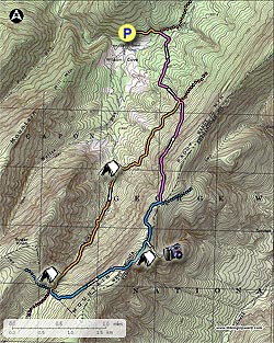
Features
- Vista / Lookout Point
- Dogs
- Mountain Summit
- Camping
Safety information
For your own safety: plan ahead, let someone know where you'll be, and hike at your own risk.
Hazards
Availability
Surface type
Share plans
Trip Reports (Reviews)
Ready to help fellow hikers? Add a trip report to share your experience!
60 Reviews
Helpful Links
Popular categories


You may also like

25 Best Day Hikes in West Virginia
Discover 25 of the best day hikes in West Virginia, from scenic overlooks to wilderness trails—perfect for every level of hiker.

25 Best Day Hikes in Virginia
Explore the top hikes in Virginia, from iconic trails in Shenandoah National Park to hidden gems in the Blue Ridge Mountains. Find your next unforgettable outdoor adventure.

Best of the Alps: Hiking, Adventure & Scenery
Plan your ultimate European Alps adventure! Discover the best hiking trails, epic scenery, and villages in the Swiss Alps, Dolomites, Chamonix, and Lake Como.

Colorado's Million Dollar Highway
Plan a day's drive adventure along the iconic Million Dollar Highway in Colorado. Explore the best short trails, roadside stops, waterfalls, vistas, ghost towns, and hot springs within a ~6 hour road trip.
Become a Supporter

Get Directions
Ready for your hike? Select a map app below for turn-by-turn directions to the trailhead.
Stay Connected
Join our community of hikers
Follow MyHikes on Facebook Follow MyHikes on Instagram Follow MyHikes on Bluesky Follow MyHikes on Pinterest