Loading...

๐ŸŽ‰ Enjoy a Free 7-Day Supporter Trial and Unlock Exclusive Perks โ€” No Credit Card Required. Learn more.

White Pines Trail

Directions
Map
Pictures
Send to App
Distance:
0.4 Miles / 0.6 km
Type:
One-Way
Difficulty:
Easy
Time to Hike:
~12 minutes
Features:
Surface Type:
Universal Access
Park:
Wolfe's Neck Woods State Park
Town:
Freeport, Maine
Directions:
43.822246, -70.083028
Added:
July 14, 2024
Updated:
July 29, 2024
Copy Trail Link Hiking this trail? Send a friend or family member a link to this trail guide for your own safety. Hike at your own risk (disclaimer)
Loading...
Loading...
45'

Total Change
9'

Ascent
32'

Descent

Download the Trail Route for Offline Use

Supporters get exclusive access to download trail routes to the MyHikes app for offline use. Stay prepared on your adventure, even without an internet connection! Become a Supporter today to unlock this feature and hike with confidence.

Send to App

White Pines Trail

The White Pines Trail at Wolfe's Neck Woods State Park near Freeport, Maine is an easy universally-accessible 0.4-mile on-way trail that features a peaceful forest setting and views of Casco Bay.

Hike
This short trail begins at the northern side of the parking lot and follows the "White Pines" trail signs. Hikers will find the universally-accessible dirt trail winding through the woods along a very-easy surface grade. The trail leads into the woods before it curves eastward toward the ocean. During our hike here in July 2024, we found several re-printed paintings on sign posts along the trail which added to the experience and scenery.

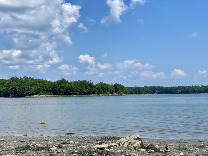
Non-Accessible Staircase and Bay View - Mile 0.2
The best view of Casco Bay (unobstructed) along this trail is along the coastline after hiking down a series of stairs, located around mile 0.2. Unfortunately this view is not universally-accessible, but for folks who can't hike up or down the stairs you can still enjoy obstructed views of the ocean from the trail.

The trail continues following its easy-graded surface until it reaches the Casco Bay Trail where this trail ends.

Parking & Fees
There's a per-person entry fee, as of July 2024. For non-residents, it's a $6/adult fee. For Maine residents, the fee is $4/adult. Hikers will find a large parking lot at the end of the park's entrance road which can hold several dozen vehicles as of July 2024.

Pets
Dogs are allowed only if leashed and must be cleaned up after.
Explore 27 trails near Freeport, ME
  1. Parking

    43.822246, -70.083028
  2. Main Trailhead

    43.822246, -70.083028
  3. View of the ocean (non-accessible)

    43.823036, -70.081322
    View of the ocean (non-accessible)
No community routes found. To add your own hike as a Community Route for this Trail guide, leave a Trip Report with an attached GPX file.

Hazards

Ticks - Lyme Disease More Info (CDC)
Poison Ivy/Oak

Seasons

All

Photo Albums

Trip Reports

Trail Guide By:
Admin user profile picture
0.4 miles / 0.6 km
0.4 miles / 0.6 km
July 14, 2024
Short and easy trail with less people than the Casco Bay Trail that this connects to.
Dogs Hiking

Weather Forecast

In Freeport, ME

Explore Hiking Trails

You May Also Like

Colorado's Million Dollar Highway - Plan a day's drive adventure along the iconic Million Dollar Highway in Colorado. Explore the best short trails, roadside stops, waterfalls, vistas, ghost towns, and hot springs within a ~6 hour road trip.
Explore

Colorado's Million Dollar Highway

Plan a day's drive adventure along the iconic Million Dollar Highway in Colorado. Explore the best short trails, roadside stops, waterfalls, vistas, ghost towns, and hot springs within a ~6 hour road trip.

Read
Glacier's Going-to-the-Sun Road - Discover the breathtaking beauty of Glacier National Park along the iconic Going-to-the-Sun Road. From stunning roadside stops to picturesque waterfalls and vistas, this engineering marvel offers endless opportunities for exploration.
Explore

Glacier's Going-to-the-Sun Road

Discover the breathtaking beauty of Glacier National Park along the iconic Going-to-the-Sun Road. From stunning roadside stops to picturesque waterfalls and vistas, this engineering marvel offers endless opportunities for exploration.

Read
New York's Best Waterfalls - Whether you're planning a day hike, roadside stop, or a leisurely short walk, this guide provides hikers, travelers, and locals alike with 63 different locations to over 100 scenic waterfalls to help plan your next adventure!
Explore

New York's Best Waterfalls

Whether you're planning a day hike, roadside stop, or a leisurely short walk, this guide provides hikers, travelers, and locals alike with 63 different locations to over 100 scenic waterfalls to help plan your next adventure!

Read

Before you boogie...

Find our trail guides useful? Consider becoming a Supporter to unlock perks!

MyHikes is an indie platform that makes exploring public trails easier for everyone. The platform has no investors, no ads, and is owned and operated by one person, Dave Miller. Dave has personally mapped and written over 1,800 trail guides on MyHikes for the public to explore. MyHikes has helped millions outdoor enthusiasts plan their next adventure.

But it takes a lot of time ๐Ÿ•ฆ, money ๐Ÿ’ฐ, work, and espresso shots โ˜• to run MyHikes, including hiking , mapping , writing , and publishing new trails with high-quality (accurate) information... along with software engineering (coding) the platform like building new features, website and mobile app development (iOS and Android), site maintainance . and much much more.

Supporters unlock website and mobile app perks with an annual one-time payment of $25 (you renew) ๐Ÿ˜Ž๐Ÿ‘. Or you can simply make a Donation of your choice. Otherwise, you can support us by telling your friends about MyHikes - both quick and free ๐ŸŽ‰

Admin user profile picture

Dave Miller
MyHikes Founder