Loading...

🎉 Enjoy a Free 7-Day Supporter Trial and Unlock Exclusive Perks — No Credit Card Required. Learn more.

White Oak Canyon Hike

Directions
Map
Pictures
Send to App
Distance:
5.3 Miles / 8.5 km
Type:
Out-and-Back
Difficulty:
Moderate
Time to Hike:
2 hours, ~39 minutes
Features:
Surface Type:
Dirt
Park:
Shenandoah National Park
Town:
Ida, Virginia
Directions:
38.58613, -78.38273
Added:
March 19, 2025
Updated:
April 06, 2025
Copy Trail Link Hiking this trail? Send a friend or family member a link to this trail guide for your own safety. Hike at your own risk (disclaimer)
Loading...
Loading...
1,448'

Total Change
1,461'

Ascent
1,458'

Descent

Download the Trail Route for Offline Use

Supporters get exclusive access to download trail routes to the MyHikes app for offline use. Stay prepared on your adventure, even without an internet connection! Become a Supporter today to unlock this feature and hike with confidence.

Send to App

White Oak Canyon Hike

One of the best waterfall hikes in Shenandoah National Park. This hike isn't difficult and can easily be completed in under four hours. You can also see White Oak Canyon falls from a more difficult loop hike that also descends Cedar Run and starts at the bottom of the mountain. For a loop route see the WOC/CR hike.

Although this hike can be steep in sections it is still ok for younger children as the trail is well maintained and doesn't require any creek crossing without footbridges. Being one of the most popular hikes in the park it can be very busy in the peak seasons of spring and fall.

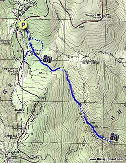
Start on a gentle grade downhill on the White Oak Canyon Trail and cross the Limberlost Trail in 0.3 miles. Continue downhill and re-crossing the Limberlost Trail and coming to the first footbridge footbridge in another 0.3 miles.

White Oak Run is now off to your left. As you get closer to the main falls, 1.0 miles after crossing the footbridge, White Oak Road will come in from your right.

Turn left over the footbridge and continue downhill for another 200 yards to arrive at the best waterfall overlook in the park and a great place for a picnic lunch.

To return just retrace your route.

Explore 96 trails near Ida, VA
  1. Parking

    38.58613, -78.38273
  2. Main Trailhead

    38.585876, -78.382859
No community routes found. To add your own hike as a Community Route for this Trail guide, leave a Trip Report with an attached GPX file.

Hazards

Ticks - Lyme Disease More Info (CDC)
Snakes
Poison Ivy/Oak

Seasons

All

Trip Reports

Trail Guide By:
HikingUpward user profile picture
5.3 miles / 8.5 km

Weather Forecast

In Ida, VA

Explore Hiking Trails

You May Also Like

New York's Best Waterfalls - Whether you're planning a day hike, roadside stop, or a leisurely short walk, this guide provides hikers, travelers, and locals alike with 63 different locations to over 100 scenic waterfalls to help plan your next adventure!
Explore

New York's Best Waterfalls

Whether you're planning a day hike, roadside stop, or a leisurely short walk, this guide provides hikers, travelers, and locals alike with 63 different locations to over 100 scenic waterfalls to help plan your next adventure!

Read
25 Best Day Hikes in North Carolina - Discover the top 25 best day hikes in North Carolina, from breathtaking waterfalls to mountain peaks. Explore hidden gems, scenic views, and trails suitable for all skill levels, perfect for your next outdoor adventure.
Explore

25 Best Day Hikes in North Carolina

Discover the top 25 best day hikes in North Carolina, from breathtaking waterfalls to mountain peaks. Explore hidden gems, scenic views, and trails suitable for all skill levels, perfect for your next outdoor adventure.

Read

Before you boogie...

Find our trail guides useful? Consider becoming a Supporter to unlock perks!

MyHikes is an indie platform that makes exploring public trails easier for everyone. The platform has no investors, no ads, and is owned and operated by one person, Dave Miller. Dave has personally mapped and written over 1,800 trail guides on MyHikes for the public to explore. MyHikes has helped millions outdoor enthusiasts plan their next adventure.

But it takes a lot of time 🕦, money 💰, work, and espresso shots ☕ to run MyHikes, including hiking , mapping , writing , and publishing new trails with high-quality (accurate) information... along with software engineering (coding) the platform like building new features, website and mobile app development (iOS and Android), site maintainance . and much much more.

Supporters unlock website and mobile app perks with an annual one-time payment of $25 (you renew) 😎👍. Or you can simply make a Donation of your choice. Otherwise, you can support us by telling your friends about MyHikes - both quick and free 🎉

Admin user profile picture

Dave Miller
MyHikes Founder