The White Loop at Stevenson Forest Preserve near Enfield, New York is an easy 0.5-mile loop hike that features small waterfalls and a peaceful walk that passes through an evergreen forest.
Trails
This hike follows two trails: White Trail, Red Trail.
Hike
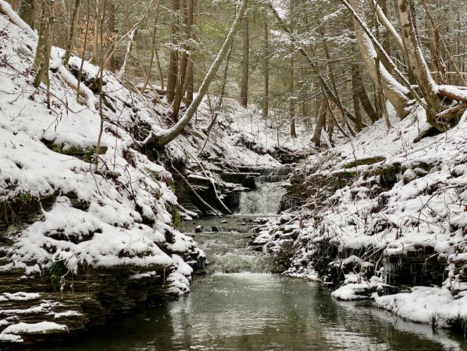
This hike begins at the main parking lot for Stevenson Forest Preserve and follows the White Trail as it leads into the woods. During colder months, when the leaves are off of the trees, hikers will pass-by a tributary creek that flows into the preserve from the West -- from the trail you'll be able to see a beautiful ~3-foot tall waterfall as it cascades down the creek located a couple-hundred feet off-trail. If you wish, you can scramble down the hillside and cross the creek to get a better view.
Staying on the White Trail, hikers will pass a trail registry before reaching the loop with the Red Trail. This GPS data brings hikers up the creek heading Northwest to follow the White Trail. Eventually the White Trail will curve to the East as it ascends a nearby hill -- this hill is full of evergreen trees, mostly Eastern Hemlocks, which give the trail a different vibe. The White Trail then gradually descends as it approaches the Red Trail.
Red Trail / Right-Hand Turn - Mile 0.4
At mile 0.4, hikers will reach a right-hand turn at the Red Trail. Hop on the Red Trail to descend back to the White Trail to complete the loop.
Once back on the White Trail, hikers can head out by following the path back to parking. Before you leave though, you can also checkout more waterfalls within the preserve located along Trumbulls Corners Road by reading our Stevenson Forest Preserve Waterfalls guide.
Parking
Hikers will find a small parking lot at the coordinates provided located on the North side of Trumbulls Corners Road. The lot is large enough to fit a half dozen vehicles as of January 2024.
Pets
Dogs are allowed only if leashed and must be cleaned up after.
Trails
This hike follows two trails: White Trail, Red Trail.
Hike
This hike begins at the main parking lot for Stevenson Forest Preserve and follows the White Trail as it leads into the woods. During colder months, when the leaves are off of the trees, hikers will pass-by a tributary creek that flows into the preserve from the West -- from the trail you'll be able to see a beautiful ~3-foot tall waterfall as it cascades down the creek located a couple-hundred feet off-trail. If you wish, you can scramble down the hillside and cross the creek to get a better view.
Staying on the White Trail, hikers will pass a trail registry before reaching the loop with the Red Trail. This GPS data brings hikers up the creek heading Northwest to follow the White Trail. Eventually the White Trail will curve to the East as it ascends a nearby hill -- this hill is full of evergreen trees, mostly Eastern Hemlocks, which give the trail a different vibe. The White Trail then gradually descends as it approaches the Red Trail.
Red Trail / Right-Hand Turn - Mile 0.4
At mile 0.4, hikers will reach a right-hand turn at the Red Trail. Hop on the Red Trail to descend back to the White Trail to complete the loop.
Once back on the White Trail, hikers can head out by following the path back to parking. Before you leave though, you can also checkout more waterfalls within the preserve located along Trumbulls Corners Road by reading our Stevenson Forest Preserve Waterfalls guide.
Parking
Hikers will find a small parking lot at the coordinates provided located on the North side of Trumbulls Corners Road. The lot is large enough to fit a half dozen vehicles as of January 2024.
Pets
Dogs are allowed only if leashed and must be cleaned up after.