Loading...

๐ŸŽ‰ Enjoy a Free 7-Day Supporter Trial and Unlock Exclusive Perks โ€” No Credit Card Required. Learn more.

Stevenson Forest Waterfalls

Directions
Map
Pictures
Send to App
Distance:
0.2 Miles / 0.3 km
Type:
Out-and-Back
Difficulty:
Easy
Time to Hike:
~6 minutes
Features:
Surface Type:
Dirt
Park:
Stevenson Forest Preserve
Town:
Enfield, New York
Directions:
42.408383, -76.639891
Added:
January 14, 2024
Updated:
February 12, 2024
Copy Trail Link Hiking this trail? Send a friend or family member a link to this trail guide for your own safety. Hike at your own risk (disclaimer)
Loading...
Loading...
24'

Total Change
34'

Ascent
34'

Descent

Download the Trail Route for Offline Use

Supporters get exclusive access to download trail routes to the MyHikes app for offline use. Stay prepared on your adventure, even without an internet connection! Become a Supporter today to unlock this feature and hike with confidence.

Send to App

Stevenson Forest Waterfalls

The Stevenson Forest Preserve Waterfalls at Stevenson Forest Preserve near Enfield, New York is an easy 0.2-mile roadside walk that features small waterfalls within the preserve.

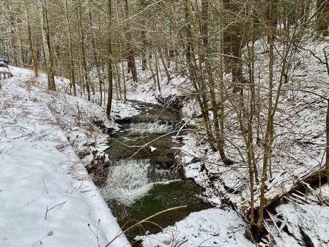
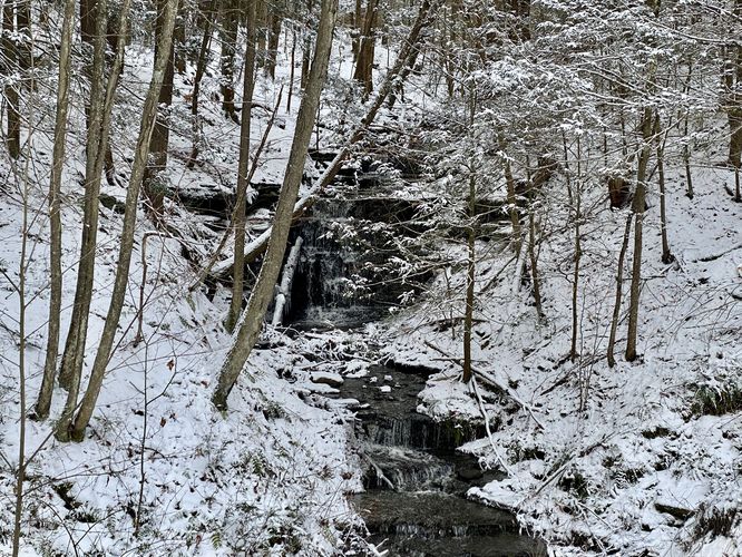
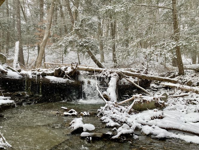
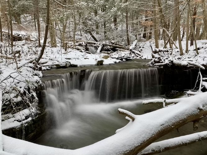
This short walk begins along the side of Trumbulls Corners Road located near the parking coordinates provided and heads downhill along Trumbulls Corners Road. Hikers will find small waterfalls and cascades within the creek in the boundary of the preserve. On this hike I documented small cascades at mile 0.01, 0.04, 0.05, and a private cascade on the east side of the road located near mile 0.1. All of the waterfalls are very short, approximately 2 to 3-feet tall, but are scenic nonetheless. The most-scenic of the cascades sits around mile 0.05 and is located off of the road -- a small amount of bushwhacking is required to reach it, but it's not far or difficult. The last waterfall is about 5-feet tall (or more) with several tiers of bedrock cascades that flow down the hillside -- however, this waterfall sits on private land so please only view it from the road.

Parking
Hikers will find two parking lots for this hike -- one at the main parking coordinates provided, which is an off-road turnout. Or you can park just down the road along Trumbulls Corners Road at the main parking lot for Stevenson Forest Preserve and simply hike this in the opposite direction out-and-back.

Pets
Dog are allowed only if leashed and must be cleaned up after.
Explore 74 trails near Enfield, NY
  1. Parking

    42.408383, -76.639891
  2. Main Trailhead

    42.408421, -76.639881
  3. Small waterfalls

    42.408531, -76.639672
    Small waterfalls
  4. 5-foot tall waterfall (private land)

    42.409092, -76.638411
    5-foot tall waterfall (private land)
  5. 2-foot tall cascade

    42.408764, -76.639344
    2-foot tall cascade
  6. 3-foot tall waterfall

    42.408881, -76.639153
    3-foot tall waterfall
No community routes found. To add your own hike as a Community Route for this Trail guide, leave a Trip Report with an attached GPX file.

Hazards

Ticks - Lyme Disease More Info (CDC)
Poison Ivy/Oak

Seasons

All

Weather Forecast

In Enfield, NY

Explore Hiking Trails

You May Also Like

Colorado's Million Dollar Highway - Plan a day's drive adventure along the iconic Million Dollar Highway in Colorado. Explore the best short trails, roadside stops, waterfalls, vistas, ghost towns, and hot springs within a ~6 hour road trip.
Explore

Colorado's Million Dollar Highway

Plan a day's drive adventure along the iconic Million Dollar Highway in Colorado. Explore the best short trails, roadside stops, waterfalls, vistas, ghost towns, and hot springs within a ~6 hour road trip.

Read
Glacier's Going-to-the-Sun Road - Discover the breathtaking beauty of Glacier National Park along the iconic Going-to-the-Sun Road. From stunning roadside stops to picturesque waterfalls and vistas, this engineering marvel offers endless opportunities for exploration.
Explore

Glacier's Going-to-the-Sun Road

Discover the breathtaking beauty of Glacier National Park along the iconic Going-to-the-Sun Road. From stunning roadside stops to picturesque waterfalls and vistas, this engineering marvel offers endless opportunities for exploration.

Read
New York's Best Waterfalls - Whether you're planning a day hike, roadside stop, or a leisurely short walk, this guide provides hikers, travelers, and locals alike with 63 different locations to over 100 scenic waterfalls to help plan your next adventure!
Explore

New York's Best Waterfalls

Whether you're planning a day hike, roadside stop, or a leisurely short walk, this guide provides hikers, travelers, and locals alike with 63 different locations to over 100 scenic waterfalls to help plan your next adventure!

Read

Before you boogie...

Find our trail guides useful? Consider becoming a Supporter to unlock perks!

MyHikes is an indie platform that makes exploring public trails easier for everyone. The platform has no investors, no ads, and is owned and operated by one person, Dave Miller. Dave has personally mapped and written over 1,800 trail guides on MyHikes for the public to explore. MyHikes has helped millions outdoor enthusiasts plan their next adventure.

But it takes a lot of time ๐Ÿ•ฆ, money ๐Ÿ’ฐ, work, and espresso shots โ˜• to run MyHikes, including hiking , mapping , writing , and publishing new trails with high-quality (accurate) information... along with software engineering (coding) the platform like building new features, website and mobile app development (iOS and Android), site maintainance . and much much more.

Supporters unlock website and mobile app perks with an annual one-time payment of $25 (you renew) ๐Ÿ˜Ž๐Ÿ‘. Or you can simply make a Donation of your choice. Otherwise, you can support us by telling your friends about MyHikes - both quick and free ๐ŸŽ‰

Admin user profile picture

Dave Miller
MyHikes Founder