The White Arrow Trail to Mt Monadnock Summit at Monadnock State Park in Jaffrey, New Hampshire is a difficult 5-mile out-and-back hike to the top of Mount Monadnock that features stunning views.
Trails: White Arrow Trail, Halfway House Road.
To access the White Arrow Trail, follow Halfway House Road for approximately 1.2-miles from the main gate. The Halfway House Road is actually a driveway that weaves its way 1.2-miles up the mountain to the trailhead for the White Arrow Trail. While there are no real views for the first 1.2-miles, it provides a relaxing and steady climb that other trails do not offer.
Once you reach the end of the access road, you will see signs indicating the White Arrow is straight ahead. The trail almost immediately turns into the rocky and steep climb that Mt Monadnock is known for. There is a brief opening located 0.1-miles off the access road, just below the summit - this is the original site of the old Halfway House. The old Halfway House lookout point provides great views to the south and some glimpses of Mt Monadnock summit.
After the Halfway House site the trail continues on up the mountain. There is a sign letting you know the summit is only 1-mile away. Compared to the popular White Dot/White Cross Trail and the Pumpelly Trail, this section is easier, but still tricky. On wet days, the trail is very slick since it's nearly all rock.
The White Arrow Trail is the only clearly marked trail in this area and there are several side trails along the way. The only marking that I saw was for the Amphitheater Trail which is roughly 0.4-miles up the White Arrow Trail.
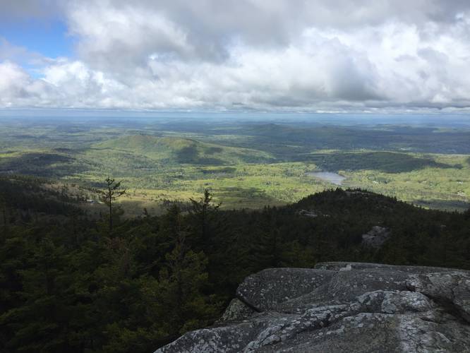
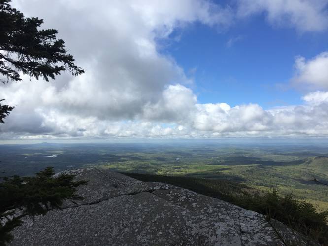
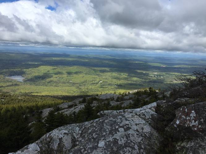
The scramble for the summit starts around the 0.4-mile mark below the summit - or approximately 2.1-miles from the start of the hike. Here, you'll clearly see a break in the trees ahead and a steep climb through the rocks. Once you make it through the rest of the forest, the trail opens up to several overlooks and open rock faces. Continue on the White Arrow Trail to the summit. As mentioned, this is one of the easier routes to the summit but just like the other trails, there are several places that require some scrambling over rock faces and caution is advised.
After visiting the summit, the hike back downhill is another 2.5-miles out. Hiking poles or walking sticks are recommended to help take some weight off of your knees.
Parking: There is a large parking lot at the coordinates provided and it costs $5 to park.
Fee: There's a $5 parking fee.
Facilities: Two portable toilets are generally available at the parking lot for hikers to use.
Warnings: Be aware of the weather and always plan for cold wind at the top of the mountain. While the weather at the bottom of the mountain may be calm, the wind on top can be very strong.
Proper footwear is also recommended, with a good grip, since there are many rock faces that can be slick even on dry days.
Trails: White Arrow Trail, Halfway House Road.
To access the White Arrow Trail, follow Halfway House Road for approximately 1.2-miles from the main gate. The Halfway House Road is actually a driveway that weaves its way 1.2-miles up the mountain to the trailhead for the White Arrow Trail. While there are no real views for the first 1.2-miles, it provides a relaxing and steady climb that other trails do not offer.
Once you reach the end of the access road, you will see signs indicating the White Arrow is straight ahead. The trail almost immediately turns into the rocky and steep climb that Mt Monadnock is known for. There is a brief opening located 0.1-miles off the access road, just below the summit - this is the original site of the old Halfway House. The old Halfway House lookout point provides great views to the south and some glimpses of Mt Monadnock summit.
After the Halfway House site the trail continues on up the mountain. There is a sign letting you know the summit is only 1-mile away. Compared to the popular White Dot/White Cross Trail and the Pumpelly Trail, this section is easier, but still tricky. On wet days, the trail is very slick since it's nearly all rock.
The White Arrow Trail is the only clearly marked trail in this area and there are several side trails along the way. The only marking that I saw was for the Amphitheater Trail which is roughly 0.4-miles up the White Arrow Trail.
The scramble for the summit starts around the 0.4-mile mark below the summit - or approximately 2.1-miles from the start of the hike. Here, you'll clearly see a break in the trees ahead and a steep climb through the rocks. Once you make it through the rest of the forest, the trail opens up to several overlooks and open rock faces. Continue on the White Arrow Trail to the summit. As mentioned, this is one of the easier routes to the summit but just like the other trails, there are several places that require some scrambling over rock faces and caution is advised.
After visiting the summit, the hike back downhill is another 2.5-miles out. Hiking poles or walking sticks are recommended to help take some weight off of your knees.
Parking: There is a large parking lot at the coordinates provided and it costs $5 to park.
Fee: There's a $5 parking fee.
Facilities: Two portable toilets are generally available at the parking lot for hikers to use.
Warnings: Be aware of the weather and always plan for cold wind at the top of the mountain. While the weather at the bottom of the mountain may be calm, the wind on top can be very strong.
Proper footwear is also recommended, with a good grip, since there are many rock faces that can be slick even on dry days.