Loading...

๐ŸŽ‰ Enjoy a Free 7-Day Supporter Trial and Unlock Exclusive Perks โ€” No Credit Card Required. Learn more.

Mt Monadnock White Dot Trail

Directions
Map
Pictures
Send to App
Distance:
4.2 Miles / 6.8 km
Type:
Loop
Difficulty:
Strenuous
Time to Hike:
2 hours, ~6 minutes
Features:
Surface Type:
Dirt
Park:
Monadnock State Park
Town:
Jaffrey, New Hampshire
Directions:
42.845356, -72.087292
Added:
July 13, 2017
Updated:
July 08, 2019
Copy Trail Link Hiking this trail? Send a friend or family member a link to this trail guide for your own safety. Hike at your own risk (disclaimer)
Loading...
Loading...
1,811'

Total Change
1,897'

Ascent
1,897'

Descent

Download the Trail Route for Offline Use

Supporters get exclusive access to download trail routes to the MyHikes app for offline use. Stay prepared on your adventure, even without an internet connection! Become a Supporter today to unlock this feature and hike with confidence.

Send to App

Mt Monadnock White Dot Trail

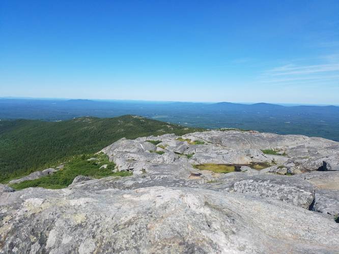
The White Dot Trail up to Mount Monadnock near Jaffrey New Hampshire is a difficult 4.2 mile loop hike that brings you to the summit of Monadnock with amazing views of the surrounding area above the treeline.

Take the White Dot Trail up and the White Cross Trail down. The elevation change is fairly high for southern New Hampshire at about 1700 feet, so bring plenty of water for your trip.

This is steep nearly the whole way and is one of the most hiked mountains in the northeast. Weekends are a popular day hike for families and groups, so if you want to experience Monadnock on a quiet day, try hiking up during a weekday. Day camps go up all the time, but its still a bear of a hike.

Pets/dogs: are not permitted in Monadnock State Park.
Explore 103 trails near Jaffrey, NH
  1. Parking

    42.845356, -72.087292
  2. Main Trailhead

    42.844879, -72.087291
  3. Mount Monadnock Summit

    42.861491, -72.10811
    Mount Monadnock Summit
No community routes found. To add your own hike as a Community Route for this Trail guide, leave a Trip Report with an attached GPX file.

Hazards

Ticks - Lyme Disease More Info (CDC)

Season

Spring

Trip Reports

Trail Guide By:
Tocra user profile picture
4.2 miles / 6.8 km
4.2 miles / 6.8 km
July 07, 2019
This steep loop is best done counter clockwise going up White Dot, and down White Cross. Most of the trail will be climbing up stone stairs and large stone slopes, with some hand over foot scrambling. It's doable for kids, but I don't think dogs are allowed. There's bathrooms and water at the trailhead but no place to refill or filter water on the way up, so bring 2 liters per person, especially on a hot day. I also recommend bugspray, and sunscreen will be needed at the top, as it's quite exposed with little shade. Overall a great trail with amazing 360 views at the top. There were a decent amount of people on the trails this weekend, but parking was still available and the summit has a ton of room to find your own private spot.
Hiking

Weather Forecast

In Jaffrey, NH

Explore Hiking Trails

You May Also Like

Colorado's Million Dollar Highway - Plan a day's drive adventure along the iconic Million Dollar Highway in Colorado. Explore the best short trails, roadside stops, waterfalls, vistas, ghost towns, and hot springs within a ~6 hour road trip.
Explore

Colorado's Million Dollar Highway

Plan a day's drive adventure along the iconic Million Dollar Highway in Colorado. Explore the best short trails, roadside stops, waterfalls, vistas, ghost towns, and hot springs within a ~6 hour road trip.

Read
Glacier's Going-to-the-Sun Road - Discover the breathtaking beauty of Glacier National Park along the iconic Going-to-the-Sun Road. From stunning roadside stops to picturesque waterfalls and vistas, this engineering marvel offers endless opportunities for exploration.
Explore

Glacier's Going-to-the-Sun Road

Discover the breathtaking beauty of Glacier National Park along the iconic Going-to-the-Sun Road. From stunning roadside stops to picturesque waterfalls and vistas, this engineering marvel offers endless opportunities for exploration.

Read
New York's Best Waterfalls - Whether you're planning a day hike, roadside stop, or a leisurely short walk, this guide provides hikers, travelers, and locals alike with 63 different locations to over 100 scenic waterfalls to help plan your next adventure!
Explore

New York's Best Waterfalls

Whether you're planning a day hike, roadside stop, or a leisurely short walk, this guide provides hikers, travelers, and locals alike with 63 different locations to over 100 scenic waterfalls to help plan your next adventure!

Read

Before you boogie...

Find our trail guides useful? Consider becoming a Supporter to unlock perks!

MyHikes is an indie platform that makes exploring public trails easier for everyone. The platform has no investors, no ads, and is owned and operated by one person, Dave Miller. Dave has personally mapped and written over 1,800 trail guides on MyHikes for the public to explore. MyHikes has helped millions outdoor enthusiasts plan their next adventure.

But it takes a lot of time ๐Ÿ•ฆ, money ๐Ÿ’ฐ, work, and espresso shots โ˜• to run MyHikes, including hiking , mapping , writing , and publishing new trails with high-quality (accurate) information... along with software engineering (coding) the platform like building new features, website and mobile app development (iOS and Android), site maintainance . and much much more.

Supporters unlock website and mobile app perks with an annual one-time payment of $25 (you renew) ๐Ÿ˜Ž๐Ÿ‘. Or you can simply make a Donation of your choice. Otherwise, you can support us by telling your friends about MyHikes - both quick and free ๐ŸŽ‰

Admin user profile picture

Dave Miller
MyHikes Founder