The West Branch Trail at Tioga State Forest near Stony Fork and in Morris, Pennsylvania is a moderate 5.9-mile out-and-back trail that leads to a beautiful 6-foot slide waterfall, West Branch Falls. This trail also ends at the convergence with West Branch Stony Fork and East Branch Stony Fork creeks, which is where Stony Fork creek begins.
The trail starts at the yellow service road gate and follows a logging road down several switchbacks to reach the main trail. Hikers should note that the easiest way to reach the main trail is to continue hiking downhill along the service road until it gradually follows along West Branch Stony Fork creek. Otherwise, the trailhead as listed on the state forest map, is slightly overgrown and not worth the hassle if you do not plan to bushwhack.
After hiking down switchbacks the trail gradually heads downhill as it follows West Branch Stony Fork creek. During the Spring, Fall, and Winter the trail has some seasonal obstructed views of the neighboring mountains, namely Fork Point.
During the Spring, hikers may find beautiful maroon Trillium, squirrel corn, and other wildflowers growing along the steeper hillsides off of the trail.
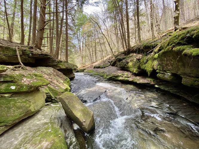
Just before reaching the end of the trail, hikers will find the main destination of this hike - West Branch Falls and the beautiful rock grotto that it cascades down. West Branch Falls is a very small, approximately 6-foot tall slide waterfall that runs down the bedrock in the creek.
The West Branch Falls grotto, along with the junction of the West Branch Stony Fork and East Branch Stony Fork creeks makes this a peaceful and secluded hike. The hike back uphill is easy until you reach the switchbacks, which offer their own challenge, but the elevation grade is not very steep.
West Branch Falls
The main destination of this hike, West Branch Falls, is a short 6-foot slide waterfall that cascades down West Branch Stony Fork creek. The grotto that the waterfall lies within can be found approximately 100-feet upstream from where the trail ends, or where West Branch Stony Fork converges with East Branch Stony Fork creek. Reaching the creek and the waterfall will require some off-trail bushwhacking for no more than about 30-feet from the trail.
Parking
Hikers can find parking at the coordinates provided. The space is large enough for one vehicle. The parking area is technically a service road that leads into and blocks a service gate; however, there are no signs stating not to block the gate like at other service road trailheads at Tioga State Forest. We list one vehicle for space here since if two different hikers show up, they will block-in the first hiker that arrives.
Pets
Dogs are allowed if leashed.
Camping and Backpacking
Backpackers will find there are no pre-built campsites along this trail, but Tioga State Forest's primitive/dispersed/backcountry camping rules permit camping off of this trail.
Winter Road Conditions
Tioga State Forest does not maintain this road during the winter. Do not attempt driving on this road without proper equipment including snow tires and/or chains unless the road is clear. High wind storms may also cause trees to fall across the road, making the road impassible. If you plan to visit during the winter, plan accordingly.
Warnings
Rattlesnakes: While rare, the Timber Rattlesnake lives in this area and tends to come down to creeks to cool down or hunt between the end of April through the end of September. Watch your step and give any rattlesnake you see some space.
The trail starts at the yellow service road gate and follows a logging road down several switchbacks to reach the main trail. Hikers should note that the easiest way to reach the main trail is to continue hiking downhill along the service road until it gradually follows along West Branch Stony Fork creek. Otherwise, the trailhead as listed on the state forest map, is slightly overgrown and not worth the hassle if you do not plan to bushwhack.
After hiking down switchbacks the trail gradually heads downhill as it follows West Branch Stony Fork creek. During the Spring, Fall, and Winter the trail has some seasonal obstructed views of the neighboring mountains, namely Fork Point.
During the Spring, hikers may find beautiful maroon Trillium, squirrel corn, and other wildflowers growing along the steeper hillsides off of the trail.
Just before reaching the end of the trail, hikers will find the main destination of this hike - West Branch Falls and the beautiful rock grotto that it cascades down. West Branch Falls is a very small, approximately 6-foot tall slide waterfall that runs down the bedrock in the creek.
The West Branch Falls grotto, along with the junction of the West Branch Stony Fork and East Branch Stony Fork creeks makes this a peaceful and secluded hike. The hike back uphill is easy until you reach the switchbacks, which offer their own challenge, but the elevation grade is not very steep.
West Branch Falls
The main destination of this hike, West Branch Falls, is a short 6-foot slide waterfall that cascades down West Branch Stony Fork creek. The grotto that the waterfall lies within can be found approximately 100-feet upstream from where the trail ends, or where West Branch Stony Fork converges with East Branch Stony Fork creek. Reaching the creek and the waterfall will require some off-trail bushwhacking for no more than about 30-feet from the trail.
Parking
Hikers can find parking at the coordinates provided. The space is large enough for one vehicle. The parking area is technically a service road that leads into and blocks a service gate; however, there are no signs stating not to block the gate like at other service road trailheads at Tioga State Forest. We list one vehicle for space here since if two different hikers show up, they will block-in the first hiker that arrives.
Pets
Dogs are allowed if leashed.
Camping and Backpacking
Backpackers will find there are no pre-built campsites along this trail, but Tioga State Forest's primitive/dispersed/backcountry camping rules permit camping off of this trail.
Winter Road Conditions
Tioga State Forest does not maintain this road during the winter. Do not attempt driving on this road without proper equipment including snow tires and/or chains unless the road is clear. High wind storms may also cause trees to fall across the road, making the road impassible. If you plan to visit during the winter, plan accordingly.
Warnings
Rattlesnakes: While rare, the Timber Rattlesnake lives in this area and tends to come down to creeks to cool down or hunt between the end of April through the end of September. Watch your step and give any rattlesnake you see some space.