Waipo'o Falls at Waimea Canyon State Park near Waimea, Hawaii (Kauai) is a moderate and popular 3.3-mile out-and-back hike that leads to the top of the 800-foot waterfall, Waipo'o Falls, and includes two smaller waterfalls, Upper and Lower Waipo'o Falls which feature views of the falls in addition to a small swimming hole.
Note that hikers can't see the full 800-foot Waipo'o Falls without being on a helicopter tour or by simply driving to the Waipo'o Falls Lookout, so this hike features the two smaller waterfalls, a chance to get wet, and includes stunning views of Waimea Canyon. Going to the edge and top of Waipo'o Falls' 800-foot plummet is not advised especially if the rocks are wet.
Trails
This hike follows two named trails: Canyon Trail - leads to Waipo'o Falls. Cliff Trail - a spur trail that leads to a very quiet view of Waimea Canyon.
Hike Description
This hike begins at the main parking lot for the Pu'u Hinahina Lookout and follows the Canyon Trail to start. The trailhead for the Canyon Trail is located at the very end of the parking lot. Hikers will start out along a fairly-gradual path as it leads downhill along well-beaten Kauai red dirt through the lush rainforest. During times of rain or just afterward, this trail can be very slick and slippery. After 0.1-miles into the hike, the trail will begin to head downhill along a steep grade for approximately 0.3-miles. Along this section, there are some switchbacks that help with the elevation change. In addition, there are several spots where hikers can stop to wait for other groups to pass. Just afterward, the trail will cross a stream before it begins a steep ascent for just 0.15-miles.
Off-Road Parking Area - Mile 0.65
For hikers, or locals, with 4 Wheel Drive vehicles, there's a parking lot along the Canyon Trail around mile 0.65 (22.113231,-159.66521) which can be used to shorten the mileage. Note that the road that leads down to the lot appears to be deeply rutted and only for 4 Wheel Drive vehicles.
Cliff Trail - Mile 0.7
At mile 0.7, hikers will reach a junction to the Cliff Trail. Here, we turned off the Canyon Trail to explore this trail and its overlook of Waimea Canyon. The Cliff Trail is very secluded, compared to the Canyon Trail, since 95% of the hikers (shall I say visitors) skip this trail and continue on to Waipo'o Falls, making this a quiet and secluded gem along the hike. Maybe we got lucky on this trip, but despite spending 10+ minutes on this 0.3-mile out-and-back spur trail, we saw no other hikers.
Steep Sections - Mile 1 to 1.5
After hiking the Cliff Trail, hikers will have exactly 1 mile completed. From the Cliff Trail junction, down another 0.5 miles, are several steep sections of hills to traverse. While none of them last very long, each section is tiring, and hikers should carefully watch their steps. Near the tail-end of this 0.5-mile section of trail, the path will become skinny along a somewhat steep, but heavily-vegetated canyon slope, so hikers may need to wait their turn to pass here.
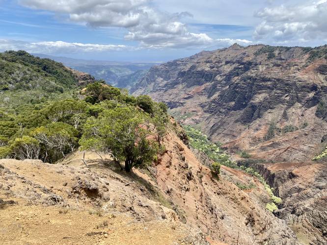
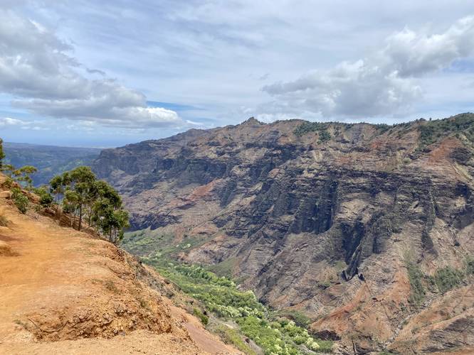
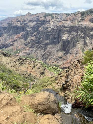
Waimea Canyon Views - Mile 1.55 to 1.7
At mile 1.55, the trail will open up to a beautiful 180-degree view of Waimea Canyon as the trail slowly ascends the last hill before descending to Waipo'o Falls. This area is a popular spot to take in the views; however, there's not a lot of shade provided here. Just after, the trail will descend this hill along a moderate-to-steep grade to reach the waterfalls.
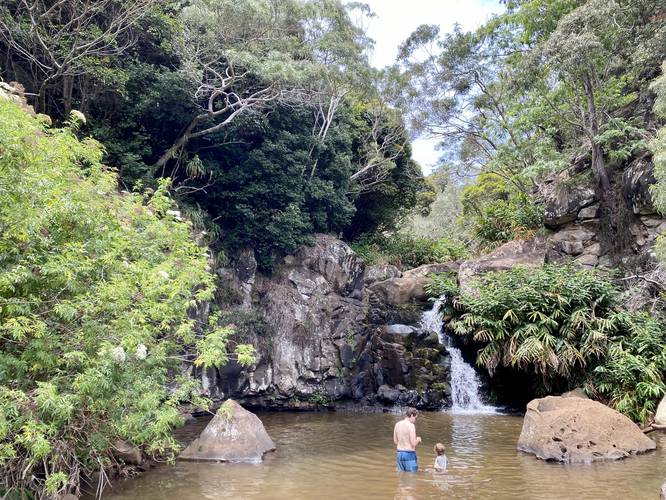
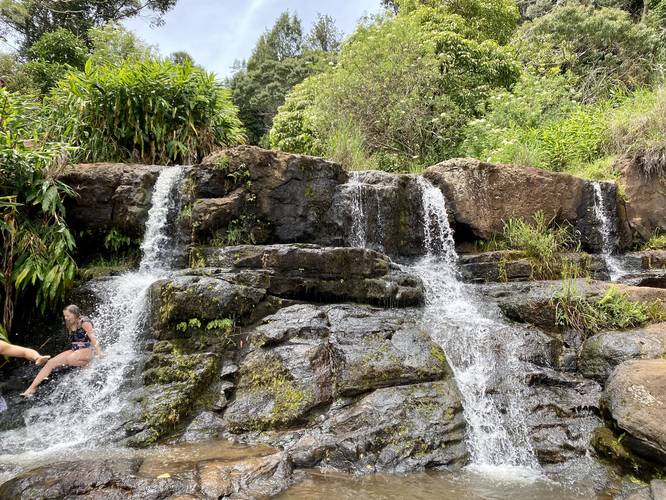
Upper Waipo'o Falls (10-foot waterfall), Left-Hand Turn - Mile 1.7 to 1.77
At mile 1.7, hikers will reach a left-hand turn that leads along a gradual grade. If you see the steep trail headed downhill adjacent to the Waimea Canyon cliffs, skip that, since it's safer to hike up that route rather than down. Hikers will reach one more junction, around mile 1.75 - take a left-hand turn here to reach Upper Waipo'o Falls at mile 1.77. Upper Waipo'o Falls cascades down Koke'e Stream at about 10-feet tall. The pool of water here is large enough to get wet and is likely a few feet deep.
Reaching Lower Waipo'o Falls (12-foot waterfall) - Mile 1.77 to 1.9
The easiest way to reach Lower Waipo'o Falls is by heading back to the last junction you found and to take the opposite turn; however, this GPS track leads east of Upper Waipo'o Falls along a very skinny, slightly-dangerous, and annoying path that runs along the eastern side of Koke'e Stream. The rocks and boulders within Koke'e Stream, at Upper Falls, make it challenging and thus we don't recommend this route. If you find yourself on this route, however, you can slowly make your way south to reach another junction that leads back down to Koke'e Stream - hike this to reach the top of Lower Waipo'o Falls. Then take the short, but very steep, path to reach the base of Lower Waipo'o Falls around mile 1.9. Lower Waipo'o Falls (despite being above the main 800-foot cascade) is about 12-feet tall with no real swimming opportunities, but hikers can cool off in the water as it spills over the bedrock.
Waipo'o Falls (800-foot waterfall) - Mile 1.9
Once the hiker is at Lower Waipo'o Falls, they'll also be at the top of the main waterfall, Waipo'o Falls, which cascades down into Waimea Canyon at about 800-feet or more. Rocks can be slippery near the edge here and it's not recommended to try and view Waipo'o Falls since you'd have to be in a helicopter to really see it. However, hikers can cool off in Lower Waipo'o Falls just by hanging out in Koke'e Stream right here.
Hiking Out
Upon this hike, we decided to ascend the steep trail that hikers will reach around mile 1.7 on the hike in - this leads directly from Lower Waipo'o Falls back to the main trail. This trail is pretty sketchy and thus, despite being in the recording, not recommended to hike it unless you're an experienced hiker. Most people will want to head back up the trail by heading toward Upper Falls and then hiking the gradual path instead. Despite which route you take, the hike back will be similar for most people - waiting your turn, taking breaks along switchbacks, and slowly ascending back to parking.
Parking & Fees
Visitors will find a large parking lot at the coordinates provided. The lot is large enough to fit several dozen vehicles and overflow parking can be found on the road. There's a vehicle entry fee in addition to individual fees as of June, 2022. By paying for one parking lot, the tickets are valid for all parking lots that require fees for both the Waimea Canyon State Park and Koke'e State Park. Note that for visitors with valid Hawaiian drivers licenses, there are no fees to park or enter.
Warnings
Steep terrain: This trail follows some sections of steep terrain. Additionally, some of these steep sections are located near very steep cliffs. Give yourself enough room and stay away from the edge of cliffs. Trekking poles and proper footwear are advised to have an enjoyable hike since shoes with minimal grip will mean that visitors will be slipping and sliding down the red dirt trail, potentially ruining their clothing or putting themselves at risk of injury.
Slippery rocks: The rocks near Upper and Lower Waipo'o Falls can be slippery when wet. It's best to avoid walking close to the top of any of these waterfalls to avoid any accidental falls, especially when near the top of the 800-foot drop of Waipo'o Falls, just downstream of Lower Falls.
Flash floods: Koke'e Stream is known to have flash floods without any warning. Hikers should be aware of the dangers and always be on the lookout (or keep their ears tuned to listen) for signs that a flash flood may be coming. Dark and heavy storm clouds upstream may indicate that a heavy rain is headed downstream, so always be cautious.
Popular trail: As a warning, this trail is very popular, and thus hikers should wait for large groups to pass-by in areas where the trail becomes very skinny, tight, or dangerous. Waiting your turn on the trail is half of the battle when hiking Waipo'o Falls. Due to all of the waiting, this increases the time to hike to approximately 2-hours or more for the average hiker.
Respecting the Land
Hawaiian land is considered sacred to native Hawaiians and many locals, so please stay on-trail, take nothing but photos, and leave nothing but footprints. Respect the locals - don't stay for long and have a backup hike planned in case the parking lot is full.
Note that hikers can't see the full 800-foot Waipo'o Falls without being on a helicopter tour or by simply driving to the Waipo'o Falls Lookout, so this hike features the two smaller waterfalls, a chance to get wet, and includes stunning views of Waimea Canyon. Going to the edge and top of Waipo'o Falls' 800-foot plummet is not advised especially if the rocks are wet.
Trails
This hike follows two named trails: Canyon Trail - leads to Waipo'o Falls. Cliff Trail - a spur trail that leads to a very quiet view of Waimea Canyon.
Hike Description
This hike begins at the main parking lot for the Pu'u Hinahina Lookout and follows the Canyon Trail to start. The trailhead for the Canyon Trail is located at the very end of the parking lot. Hikers will start out along a fairly-gradual path as it leads downhill along well-beaten Kauai red dirt through the lush rainforest. During times of rain or just afterward, this trail can be very slick and slippery. After 0.1-miles into the hike, the trail will begin to head downhill along a steep grade for approximately 0.3-miles. Along this section, there are some switchbacks that help with the elevation change. In addition, there are several spots where hikers can stop to wait for other groups to pass. Just afterward, the trail will cross a stream before it begins a steep ascent for just 0.15-miles.
Off-Road Parking Area - Mile 0.65
For hikers, or locals, with 4 Wheel Drive vehicles, there's a parking lot along the Canyon Trail around mile 0.65 (22.113231,-159.66521) which can be used to shorten the mileage. Note that the road that leads down to the lot appears to be deeply rutted and only for 4 Wheel Drive vehicles.
Cliff Trail - Mile 0.7
At mile 0.7, hikers will reach a junction to the Cliff Trail. Here, we turned off the Canyon Trail to explore this trail and its overlook of Waimea Canyon. The Cliff Trail is very secluded, compared to the Canyon Trail, since 95% of the hikers (shall I say visitors) skip this trail and continue on to Waipo'o Falls, making this a quiet and secluded gem along the hike. Maybe we got lucky on this trip, but despite spending 10+ minutes on this 0.3-mile out-and-back spur trail, we saw no other hikers.
Steep Sections - Mile 1 to 1.5
After hiking the Cliff Trail, hikers will have exactly 1 mile completed. From the Cliff Trail junction, down another 0.5 miles, are several steep sections of hills to traverse. While none of them last very long, each section is tiring, and hikers should carefully watch their steps. Near the tail-end of this 0.5-mile section of trail, the path will become skinny along a somewhat steep, but heavily-vegetated canyon slope, so hikers may need to wait their turn to pass here.
Waimea Canyon Views - Mile 1.55 to 1.7
At mile 1.55, the trail will open up to a beautiful 180-degree view of Waimea Canyon as the trail slowly ascends the last hill before descending to Waipo'o Falls. This area is a popular spot to take in the views; however, there's not a lot of shade provided here. Just after, the trail will descend this hill along a moderate-to-steep grade to reach the waterfalls.
Upper Waipo'o Falls (10-foot waterfall), Left-Hand Turn - Mile 1.7 to 1.77
At mile 1.7, hikers will reach a left-hand turn that leads along a gradual grade. If you see the steep trail headed downhill adjacent to the Waimea Canyon cliffs, skip that, since it's safer to hike up that route rather than down. Hikers will reach one more junction, around mile 1.75 - take a left-hand turn here to reach Upper Waipo'o Falls at mile 1.77. Upper Waipo'o Falls cascades down Koke'e Stream at about 10-feet tall. The pool of water here is large enough to get wet and is likely a few feet deep.
Reaching Lower Waipo'o Falls (12-foot waterfall) - Mile 1.77 to 1.9
The easiest way to reach Lower Waipo'o Falls is by heading back to the last junction you found and to take the opposite turn; however, this GPS track leads east of Upper Waipo'o Falls along a very skinny, slightly-dangerous, and annoying path that runs along the eastern side of Koke'e Stream. The rocks and boulders within Koke'e Stream, at Upper Falls, make it challenging and thus we don't recommend this route. If you find yourself on this route, however, you can slowly make your way south to reach another junction that leads back down to Koke'e Stream - hike this to reach the top of Lower Waipo'o Falls. Then take the short, but very steep, path to reach the base of Lower Waipo'o Falls around mile 1.9. Lower Waipo'o Falls (despite being above the main 800-foot cascade) is about 12-feet tall with no real swimming opportunities, but hikers can cool off in the water as it spills over the bedrock.
Waipo'o Falls (800-foot waterfall) - Mile 1.9
Once the hiker is at Lower Waipo'o Falls, they'll also be at the top of the main waterfall, Waipo'o Falls, which cascades down into Waimea Canyon at about 800-feet or more. Rocks can be slippery near the edge here and it's not recommended to try and view Waipo'o Falls since you'd have to be in a helicopter to really see it. However, hikers can cool off in Lower Waipo'o Falls just by hanging out in Koke'e Stream right here.
Hiking Out
Upon this hike, we decided to ascend the steep trail that hikers will reach around mile 1.7 on the hike in - this leads directly from Lower Waipo'o Falls back to the main trail. This trail is pretty sketchy and thus, despite being in the recording, not recommended to hike it unless you're an experienced hiker. Most people will want to head back up the trail by heading toward Upper Falls and then hiking the gradual path instead. Despite which route you take, the hike back will be similar for most people - waiting your turn, taking breaks along switchbacks, and slowly ascending back to parking.
Parking & Fees
Visitors will find a large parking lot at the coordinates provided. The lot is large enough to fit several dozen vehicles and overflow parking can be found on the road. There's a vehicle entry fee in addition to individual fees as of June, 2022. By paying for one parking lot, the tickets are valid for all parking lots that require fees for both the Waimea Canyon State Park and Koke'e State Park. Note that for visitors with valid Hawaiian drivers licenses, there are no fees to park or enter.
Warnings
Steep terrain: This trail follows some sections of steep terrain. Additionally, some of these steep sections are located near very steep cliffs. Give yourself enough room and stay away from the edge of cliffs. Trekking poles and proper footwear are advised to have an enjoyable hike since shoes with minimal grip will mean that visitors will be slipping and sliding down the red dirt trail, potentially ruining their clothing or putting themselves at risk of injury.
Slippery rocks: The rocks near Upper and Lower Waipo'o Falls can be slippery when wet. It's best to avoid walking close to the top of any of these waterfalls to avoid any accidental falls, especially when near the top of the 800-foot drop of Waipo'o Falls, just downstream of Lower Falls.
Flash floods: Koke'e Stream is known to have flash floods without any warning. Hikers should be aware of the dangers and always be on the lookout (or keep their ears tuned to listen) for signs that a flash flood may be coming. Dark and heavy storm clouds upstream may indicate that a heavy rain is headed downstream, so always be cautious.
Popular trail: As a warning, this trail is very popular, and thus hikers should wait for large groups to pass-by in areas where the trail becomes very skinny, tight, or dangerous. Waiting your turn on the trail is half of the battle when hiking Waipo'o Falls. Due to all of the waiting, this increases the time to hike to approximately 2-hours or more for the average hiker.
Respecting the Land
Hawaiian land is considered sacred to native Hawaiians and many locals, so please stay on-trail, take nothing but photos, and leave nothing but footprints. Respect the locals - don't stay for long and have a backup hike planned in case the parking lot is full.