Loading...

🎉 Enjoy a Free 7-Day Supporter Trial and Unlock Exclusive Perks — No Credit Card Required. Learn more.

Veach Gap and Three Dog Point Hike

Directions
Map
Pictures
Send to App
Distance:
4.5 Miles / 7.2 km
Type:
Out-and-Back
Difficulty:
Moderate
Time to Hike:
2 hours, ~15 minutes
Features:
Surface Type:
Dirt
Park:
George Washington National Forest
Town:
Seven Fountains, Virginia
Directions:
38.876146, -78.377519
Added:
February 17, 2025
Updated:
April 05, 2025
Copy Trail Link Hiking this trail? Send a friend or family member a link to this trail guide for your own safety. Hike at your own risk (disclaimer)
Loading...
Loading...
1,024'

Total Change
1,021'

Ascent
1,023'

Descent

Download the Trail Route for Offline Use

Supporters get exclusive access to download trail routes to the MyHikes app for offline use. Stay prepared on your adventure, even without an internet connection! Become a Supporter today to unlock this feature and hike with confidence.

Send to App

Veach Gap and Three Dog Point Hike

One of two hikes that start a the Veach Gap parking area, this route takes you south on the Massanutten/Tuscarora Trail to the Massanutten Mountain ridgeline and large campsite with views through the trees of the south fork of the Shenandoah River. The campsite at the high point and turnaround for this hike is suitable for multiple tents. Another camping opportunity is the Little Crease Shelter with large fire ring and privy, or the campsite where you cross Mill Run 100 yards downhill.

As a shorter out/back hike this is a great last minute backpacking hike, and this section of the Massanutten/Tuscarora is more secluded than hikes to the north and further south. An other option is the Veach Gap/South Fork Overlook hike. Slightly is longer at 7.0 miles but has better views of the river.

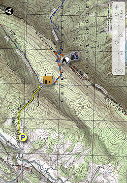
  • Mile 0.0 - From the parking area on FR774 start up the Veach Gap Trail and pass around the closed gate. Mill Run will come in on the left with the trail being wide at this point.

  • Mile 0.75 - Pass a small campsite close to the run. If you look carefully you might notice the evergreen ground cover partridgeberry along the stream bank.  In the garden the partridgeberry plant is ideal for tucking under established shrubs and perennials that provide shade from the afternoon sun. Not only is this a delightful little plant that will reward you with bright white blooms in the spring or early summer and striking red berries in the fall, but the dense foliage also helps to control weeds and conserve moisture in the perennial bed. Although it prefers moderately moist soil, partridgeberries require relatively little supplemental watering as the dense foliage serves as a living mulch to the soil, preventing moisture loss to evaporation.  Robins, Bluebirds, Veery, and Wild Turkey are just some of the birds you can attract to your yard with partridgeberry.

  • Mile 1.0 - Cross Mill Run then the Veach Gap trail remains rocky for the next 100 yards. On the left look for an interesting anticline rock formation with small cave below. Just before arriving at the Massanutten/Tuscarora Trail intersection pass a tree blazed with three colors for the three trails, Massanutten/Tuscarora/Veach Gap.

  • Mile 1.2 - Turn right on the orange/blue Massanutten/Tuscarora Trail then immediately cross Mill Run. There is a campsite that can accommodate two tents on the right. Continue south on the orange/blue trail for for 100 yards to the Little Crease Shelter.

  • Mile 1.21 - The Little Crease Shelter is large with two bunks and a privy located in the rear. From the shelter the Masanutten/Tuscarora trail gradually becomes steeper for 0.9 miles then makes a sharp right turn onto the ridge.

  • Mile 2.2 - Arrive a the intersection where the blue blazed Tuscarora Trail splits off downhill to the left. Continue straight on the orange blazed Massanutten Trail for 0.2 miles.

  • Mile 2.4 - Arrive at the Three Dog Point campsite with views through the trees of the south fork of the Shenandoah River. Return to the Veach Gap parking area reversing the route.

  • Mile 4.5 - Arrive back at the Veach Gap parking area.

Explore 96 trails near Seven Fountains, VA
  1. Parking

    38.876146, -78.377519
  2. Main Trailhead

    38.876146, -78.377519
No community routes found. To add your own hike as a Community Route for this Trail guide, leave a Trip Report with an attached GPX file.

Hazards

Ticks - Lyme Disease More Info (CDC)
Snakes
Poison Ivy/Oak

Seasons

All

Trip Reports

Trail Guide By:
HikingUpward user profile picture
4.5 miles / 7.2 km

Weather Forecast

In Seven Fountains, VA

Explore Hiking Trails

You May Also Like

New York's Best Waterfalls - Whether you're planning a day hike, roadside stop, or a leisurely short walk, this guide provides hikers, travelers, and locals alike with 63 different locations to over 100 scenic waterfalls to help plan your next adventure!
Explore

New York's Best Waterfalls

Whether you're planning a day hike, roadside stop, or a leisurely short walk, this guide provides hikers, travelers, and locals alike with 63 different locations to over 100 scenic waterfalls to help plan your next adventure!

Read
25 Best Day Hikes in North Carolina - Discover the top 25 best day hikes in North Carolina, from breathtaking waterfalls to mountain peaks. Explore hidden gems, scenic views, and trails suitable for all skill levels, perfect for your next outdoor adventure.
Explore

25 Best Day Hikes in North Carolina

Discover the top 25 best day hikes in North Carolina, from breathtaking waterfalls to mountain peaks. Explore hidden gems, scenic views, and trails suitable for all skill levels, perfect for your next outdoor adventure.

Read

Before you boogie...

Find our trail guides useful? Consider becoming a Supporter to unlock perks!

MyHikes is an indie platform that makes exploring public trails easier for everyone. The platform has no investors, no ads, and is owned and operated by one person, Dave Miller. Dave has personally mapped and written over 1,800 trail guides on MyHikes for the public to explore. MyHikes has helped millions outdoor enthusiasts plan their next adventure.

But it takes a lot of time 🕦, money 💰, work, and espresso shots ☕ to run MyHikes, including hiking , mapping , writing , and publishing new trails with high-quality (accurate) information... along with software engineering (coding) the platform like building new features, website and mobile app development (iOS and Android), site maintainance . and much much more.

Supporters unlock website and mobile app perks with an annual one-time payment of $25 (you renew) 😎👍. Or you can simply make a Donation of your choice. Otherwise, you can support us by telling your friends about MyHikes - both quick and free 🎉

Admin user profile picture

Dave Miller
MyHikes Founder