Loading...

WINTER SALE! 50% OFF Supporter Accounts — now through January 31st. Learn More.

Veach Gap and South Fork Overlook Hike

This is a secluded out and back hike in the Veach Gap area of the George Washington National Forest near Front Royal, VA. Most of the hike is a gradual ascent through Veach Gap, with a beautiful overlook and campsite at the high point.

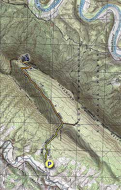
Start by passing the closed gate and heading up the yellow blazed Veach Gap Trail. Cross from the right bank over the run in 1.0 miles. After crossing the run meet the intersection of the orange/blue blazed Massanutten/Tuscarora Trail in another 0.1 miles.

Turn left on the orange/blue blazed trail as it gradually ascends Little Crease Mountain. In 0.5 miles look for a trail on your right, with a small tent symbol on a tree, that leads down to a nice camping spot.

If you look carefully you might notice the evergreen ground cover partridgeberry along the stream bank.  In the garden the partridgeberry plant is ideal for tucking under established shrubs and perennials that provide shade from the afternoon sun. Not only is this a delightful little plant that will reward you with bright white blooms in the spring or early summer and striking red berries in the fall, but the dense foliage also helps to control weeds and conserve moisture in the perennial bed. Although it prefers moderately moist soil, partridgeberries require relatively little supplemental watering as the dense foliage serves as a living mulch to the soil, preventing moisture loss to evaporation.  Robins, Bluebirds, Veery, and Wild Turkey are just some of the birds you can attract to your yard with partridgeberry.

Continue up the orange/blue blazed trail for another 1.4 miles, where the trail will turn right for 0.1 miles before turning back to the left. From this point there is a nice view of the Massanutten Valley to the southwest.

Continue up the trail passing a small rockslide, and in 0.2 miles as you reach the ridge line, arrive at the first of three overlooks. The second overlook is in another 0.2 miles. The third, and most spectacular overlook, is in another 240 feet at the high point of the hike, along with a great campsite. The sunrise is fantastic as it comes over the Shenandoah National Park to the east on a clear morning.

To return just retrace the route back to Veach Gap Trail, turn right, and continue down to the parking area.

Explore 97 trails near Seven Fountains, VA

Know Before You Go

  • This 6.9-mile out-and-back hike in George Washington National Forest near Front Royal, VA, features a gradual ascent through Veach Gap to the South Fork Overlook.
  • The trail follows yellow, orange, and blue blazes, crossing a run and intersecting with the Massanutten/Tuscarora Trail, leading to overlooks with views of Massanutten Valley and Shenandoah National Park.
  • Keep an eye out for partridgeberry, an evergreen ground cover with white blooms and red berries, and a small camping spot on the trail.
Interactive topographic map for Veach Gap and South Fork Overlook Hike located in Seven Fountains, VA. Click the "View Map" button to load GPS coordinates and trail markers.
Get directions
Distance
6.9 mi
Difficulty
Moderate
Type
Out-and-Back
Est. Time
3.5 hrs
Elev. Gain
1,103'
Rating
3.6
Added
February 17, 2025
Updated
April 05, 2025

Weather Forecast

Loading...
Total Change
1,093'
Ascent
1,103'
Descent
1,103'
Loading...

Download the GPX Data for Offline Use

Supporters get exclusive access to download trail routes to the MyHikes app for offline use. Stay prepared on your adventure, even without an internet connection! Become a Supporter today to unlock this feature and hike with confidence.

Download Veach Gap and South Fork Overlook Hike GPX Data to the MyHikes Mobile App

Features

Vista / Lookout Point
Dogs
Camping
Water Source

Points of interest

  1. Parking

    38.87611, -78.377781
  2. Main Trailhead

    38.876075, -78.377581

Safety information

For your own safety: plan ahead, let someone know where you'll be, and hike at your own risk.

Hazards

Snakes (Rattlesnakes, Copperheads, others)
Poison Ivy or Poison Oak

Markers

Blaze Color

Orange

Availability

All seasons

Surface type

Dirt

Trip Reports (Reviews)

Rated 3.64 out of 5 based on 69 ratings.

Ready to help fellow hikers? Add a trip report to share your experience and provide valuable insights for other hikers!

By: Jordan B
6.9 miles / 11.1 km
July 27, 2019
This is a great hike with a camping spot at the top. One I'll do again. This is a great trail if you like seclusion and to be out there without many other folks. I set my hammock and rain fly up just behind the 2nd overlook since it was later and I assumed no one else would be coming by. No one did. There was a couple who beat me to the prime camping spot at the 3rd overlook. I was able to look down 1000 feet into the valley below while resting in my hammock. The set up worked really well. The spots at the top would have been very exposed in a severe storm, so it isn't a place to go if there is a chance of precip. I cooked my supper and watched the Shenandoah Valley fade into darkness as the sun set behind me. I woke up before dawn and watched the sun turn the sky into brilliant shades of red over the Shenandoah NP. This was an excellent spot to drink my coffee and cook my oatmeal watching it all unfold. I then packed my stuff and quietly hiked down the mountain where I came across a few deer and a bear who didn't hear me until I was closer than I would like to be. It ran away as soon as we saw each other.
Legacy Review
By: Ash
6.9 miles / 11.1 km
June 30, 2019
I enjoyed this hike mainly because it was easy for a great view. The stream that you hike along for the first mile provides a nice soundtrack and it a good source of water for dogs. There were a lot of wild blackberry bushes full of fruit which should be ripe around mid-July. I really enjoyed the views at the top. A bonus was a large amount of wild blueberry bushes with some of the blueberries ready to eat. If you’re a fan of wild fruit I would do this hike in mid-July.
Legacy Review
By: LeoC4
6.9 miles / 11.1 km
November 07, 2018
Hiked Vetch Gap after two days of moderate (~1.5") rain. The stream crossing wasn't bad, but had to cross about 50' upstream for dryer footing. The 100 yard long section where the trail and stream merges was easily done no water shoes required (just careful foot placement). The Massanutten / Tuscarora trail section had sections of running water / mud which were passable. In addition to the stream at the Vetch Gap / Massanutten junction, there was a smaller source of water at 38.885N -78.336. Despite an attempt to locate the third overlook (and better campsite), it wasn't obvious. The trail started to descend past 38.889N -78.338 and thought (given approaching sunset) that it would be best to return to an earlier, obvious, campsite. If you've stayed at the third overlook, I'd be interested in knowing the GPS coordinates.
Legacy Review
No community routes found. To add your own hike as a Community Route for this Trail guide, leave a Trip Report with an attached GPX file.

Popular categories

Scenic mountain view representing vista trails
Vista trails
Scenic gorge of cascades representing waterfall trails
Waterfall hikes
Rugged mountain terrain representing summit trails
Summit trails
Scenic mountain view representing dog-friendly trails
Dog-friendly
Scenic campsite with a view representing camping trails
Camping trails
Appalachian Trail logo representing A.T. hikes
A.T. hikes

You May Also Like

25 Best Day Hikes in North Carolina - Discover the top 25 best day hikes in North Carolina, from breathtaking waterfalls to mountain peaks. Explore hidden gems, scenic views, and trails suitable for all skill levels, perfect for your next outdoor adventure.
Explore

25 Best Day Hikes in North Carolina

Discover the top 25 best day hikes in North Carolina, from breathtaking waterfalls to mountain peaks. Explore hidden gems, scenic views, and trails suitable for all skill levels, perfect for your next outdoor adventure.

Read
🍪 We use cookies to learn about site usage and to serve map tiles. You may block cookies manually in the browser. By continuing you agree. Learn more