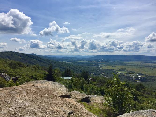
The Valley View Trail in Davis, West Virginia is an easy 0.5 mile one-way trail that leads along the western edge of the Dolly Sods Wilderness with views of Canaan Valley and the surrounding mountain ranges.
Once on the ridge, this trail is an easy walk with amazing views throughout the entirety of the hike. To the north, there's a lookout point called Windy View, which sits atop a rock that juts out from the ridge. Benches can be found along this trail as well so you can sit down and take in the views.
Backpacking Dolly Sods: If you're passing through Dolly Sods along the Rocky Ridge Trail, you should plan to hike the Valley View Trail at least one-way since the view is much better than the view you get from the Rocky Ridge Trail.
Parking: Note that there is no public parking near the trail itself as this is a gated community who have to turn visitors away. Please do not drive to the actual trailhead! The closest public parking area can be found at the coordinates provided at a very small parking lot next to the Dolly Sods FR-80 Trail -- located on a long and narrow dirt road at the top of the mountain next to the Dolly Sods Wilderness. This parking lot is approximately 2.5-miles away, one-way by foot, from the actual trail. So hikers must hike in on the Dolly Sods FR-80 Trail before reaching the Rocky Ridge Trail to reach this trail, making this a 5-miles out-and-back hike just to reach this trail. Alternatively, hikers can park along FR-75 on the east side of Dolly Sods Wilderness near the Bear Rocks Trail for a much longer hike to reach this trail. The parking lot is much larger and more accessible than the western side of Dolly Sods Wilderness, which makes it a preferable place to find parking.
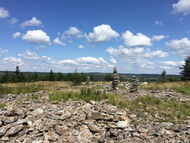
Trailheads: Please note that there are technically 3 trailheads for the Valley View Trail - the trailhead listed here can be found at the southern terminus for this trail along the Rocky Ridge Trail. The main trailhead can be found up the short spur trail from the gated community (not accessible to the general public), and the third trailhead can be found at the northern section of this GPS data, along the Rocky Ridge Trail. If you're hiking along the Rocky Ridge Trail, you can spot the northern terminus easily by finding the multitude of large stone cairns.
Once on the ridge, this trail is an easy walk with amazing views throughout the entirety of the hike. To the north, there's a lookout point called Windy View, which sits atop a rock that juts out from the ridge. Benches can be found along this trail as well so you can sit down and take in the views.
Backpacking Dolly Sods: If you're passing through Dolly Sods along the Rocky Ridge Trail, you should plan to hike the Valley View Trail at least one-way since the view is much better than the view you get from the Rocky Ridge Trail.
Parking: Note that there is no public parking near the trail itself as this is a gated community who have to turn visitors away. Please do not drive to the actual trailhead! The closest public parking area can be found at the coordinates provided at a very small parking lot next to the Dolly Sods FR-80 Trail -- located on a long and narrow dirt road at the top of the mountain next to the Dolly Sods Wilderness. This parking lot is approximately 2.5-miles away, one-way by foot, from the actual trail. So hikers must hike in on the Dolly Sods FR-80 Trail before reaching the Rocky Ridge Trail to reach this trail, making this a 5-miles out-and-back hike just to reach this trail. Alternatively, hikers can park along FR-75 on the east side of Dolly Sods Wilderness near the Bear Rocks Trail for a much longer hike to reach this trail. The parking lot is much larger and more accessible than the western side of Dolly Sods Wilderness, which makes it a preferable place to find parking.
Trailheads: Please note that there are technically 3 trailheads for the Valley View Trail - the trailhead listed here can be found at the southern terminus for this trail along the Rocky Ridge Trail. The main trailhead can be found up the short spur trail from the gated community (not accessible to the general public), and the third trailhead can be found at the northern section of this GPS data, along the Rocky Ridge Trail. If you're hiking along the Rocky Ridge Trail, you can spot the northern terminus easily by finding the multitude of large stone cairns.