Loading...

WINTER SALE! 50% OFF Supporter Accounts — now through January 31st. Learn More.

Upper Christine Falls Hike

The Upper Christine Falls hike at Mt. Rainier National Park near Ashford, WA is an easy 0.6-mile out-and-back hike that leads to the turquoise-hued upper waterfalls of Christine Falls.

Explore Upper Christine Falls

This hike begins at the trailhead for the Van Trump Trail at Mt. Rainier National Park where you'll find a staircase that quickly leads up a steep hillside, following a switchback along the way. The elevation grade continues to be somewhat moderate for a couple-hundred feet beyond the trailhead as the path leads through a dense and dark forest with filtered daylight.

After a couple minutes of walking, the trail begins to follow an easy elevation grade as it slowly makes its way toward the Van Trump Creek gorge.

Upper Christine Falls & Gorge - Mile 0.3

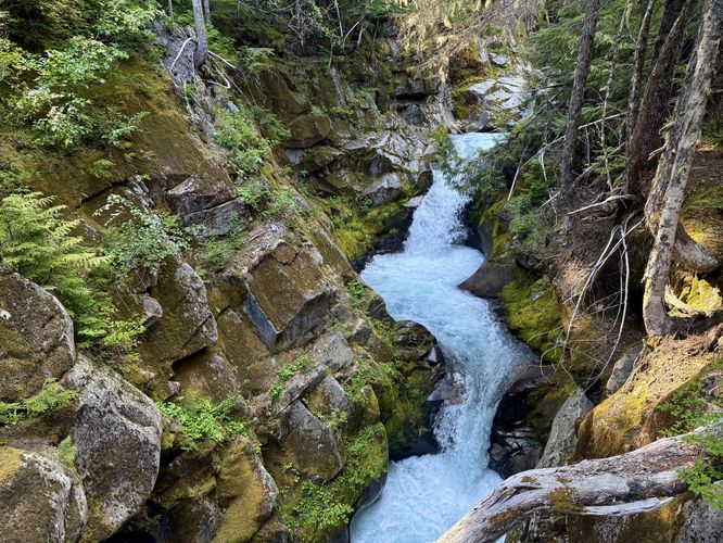
Just 0.3-miles from the trailhead sits the scenic Van Trump Creek gorge with lush moss-covered cliffs, large ferns, and the turquoise-tinted waterfalls of Upper Christine Falls in the creek below. You'll find short waterfalls cascading through the gorge that make-up the upper portion of Christine Falls. Facing upstream provides the best views of these small waterfalls. Why are these waterfalls turquoise in color? Great question! The cascade's turquoise hues are created when rock flour is washed downstream from glacier-fed creeks and tributaries. Rock flour, which is simply tiny particles of ground-up rock, is created when glaciers grind the earth and bedrock into tiny pieces, which eventually get washed downstream.

On the southern side of the gorge are views of Upper Christine Falls' remaining cascades before the water is fed to the lower portion of the waterfall Christine Falls. You can use the footbridge to take photos at different angles and perspectives, but watch your step if focused on your camera, as a fall into the gorge would likely be deadly.

Hiking Out - Mile 0.3 to 0.6

If you plan to explore the Van Trump Trail further, there's another waterfall that sits several miles from this location near the end of the trail, Comet Falls which makes for a fun but longer day hike. If the gorge was all you came to see and explore, then the hike back to parking is easy. Simply follow the trail back downhill for a short and quick 0.6-mile hike within Mt. Rainier National Park's Paradise area.

Parking & Fees

Hikers will find a medium-sized parking turnout at the coordinates provided, located at the trailhead for the Van Trump Trail. The lot is large enough to fit a couple dozen vehicles as of June 2025. As of June 2025, there's a $25 entry fee for the park which is good for several days. If you plan ahead, you can speed up your entry with an Annual National Park's Pass.

Pets

All pets, including dogs, are not allowed on any trails within Mt. Rainier National Park, so please leave your dogs at home.

Warning

Cliffs: This hike leads to the Van Trump Creek gorge where you'll find very steep cliffs and drop-offs that plummet into the rushing water below. Stay on-trail for your own safety and watch your step around the raised footbridge that spans the gorge. A slip into the gorge would likely result in immediate injury and drowning.
Explore 11 trails near Ashford, WA

Know Before You Go

  • This is a short, easy 0.6-mile hike near Ashford, WA, within Mt. Rainier National Park, leading to the turquoise-colored Upper Christine Falls.
  • The trail starts with a moderate incline through a forest, opening to views of a scenic gorge with moss-covered cliffs and waterfalls, colored by rock flour from glacial activity.
  • The hike requires a $25 park entry fee (as of June 2025), prohibits pets, and involves caution around steep cliffs and the footbridge overlooking the gorge.
Interactive topographic map for Upper Christine Falls Hike located in Ashford, WA. Click the "View Map" button to load GPS coordinates and trail markers.
Get directions
Distance
0.6 mi
Difficulty
Easy
Type
Out-and-Back
Est. Time
18 min
Elev. Gain
145'
Rating
4.0
Added
June 16, 2025
Updated
July 03, 2025

Weather Forecast

Loading...
Total Change
133'
Ascent
145'
Descent
145'
Loading...

Download the GPX Data for Offline Use

Supporters get exclusive access to download trail routes to the MyHikes app for offline use. Stay prepared on your adventure, even without an internet connection! Become a Supporter today to unlock this feature and hike with confidence.

Download Upper Christine Falls Hike GPX Data to the MyHikes Mobile App

Features

Waterfalls

Points of interest

  1. Parking

    46.778733, -121.783617
  2. Main Trailhead

    46.778733, -121.783617

Safety information

For your own safety: plan ahead, let someone know where you'll be, and hike at your own risk.

Hazards

Rockfalls, Ledges, or Scrambles

Availability

All seasons

Surface type

Dirt

Trip Reports (Reviews)

Rated 4.0 out of 5 based on 1 rating.

Ready to help fellow hikers? Add a trip report to share your experience and provide valuable insights for other hikers!

0.6 miles / 1.0 km
June 16, 2025
Quiet place to enjoy the waterfalls without many people around
Hiking
No community routes found. To add your own hike as a Community Route for this Trail guide, leave a Trip Report with an attached GPX file.

Popular categories

Scenic mountain view representing vista trails
Vista trails
Scenic gorge of cascades representing waterfall trails
Waterfall hikes
Rugged mountain terrain representing summit trails
Summit trails
Scenic mountain view representing dog-friendly trails
Dog-friendly
Scenic campsite with a view representing camping trails
Camping trails
Appalachian Trail logo representing A.T. hikes
A.T. hikes

You May Also Like

Glacier's Going-to-the-Sun Road - Discover the breathtaking beauty of Glacier National Park along the iconic Going-to-the-Sun Road. From stunning roadside stops to picturesque waterfalls and vistas, this engineering marvel offers endless opportunities for exploration.
Explore

Glacier's Going-to-the-Sun Road

Discover the breathtaking beauty of Glacier National Park along the iconic Going-to-the-Sun Road. From stunning roadside stops to picturesque waterfalls and vistas, this engineering marvel offers endless opportunities for exploration.

Read
Colorado's Million Dollar Highway - Plan a day's drive adventure along the iconic Million Dollar Highway in Colorado. Explore the best short trails, roadside stops, waterfalls, vistas, ghost towns, and hot springs within a ~6 hour road trip.
Explore

Colorado's Million Dollar Highway

Plan a day's drive adventure along the iconic Million Dollar Highway in Colorado. Explore the best short trails, roadside stops, waterfalls, vistas, ghost towns, and hot springs within a ~6 hour road trip.

Read
🍪 We use cookies to learn about site usage and to serve map tiles. You may block cookies manually in the browser. By continuing you agree. Learn more