Loading...

๐ŸŽ† 50% off 4th of July sale on Supporter Accounts โ€” now through July 6! Learn More.

Christine Falls

Directions
Map
Pictures
Send to App
Distance:
0.1 Miles / 0.2 km
Type:
Out-and-Back
Difficulty:
Easy
Time to Hike:
~5 minutes
Features:
Surface Type:
Dirt
Park:
Mt. Rainier National Park
Town:
Longmire, Washington
Directions:
46.7804, -121.778861
Added:
June 16, 2025
Updated:
July 03, 2025
Copy Trail Link Hiking this trail? Send a friend or family member a link to this trail guide for your own safety. Hike at your own risk (disclaimer)
Loading...
Loading...
22'

Total Change
22'

Ascent
22'

Descent

Download the Trail Route for Offline Use

Supporters get exclusive access to download trail routes to the MyHikes app for offline use. Stay prepared on your adventure, even without an internet connection! Become a Supporter today to unlock this feature and hike with confidence.

Send to App

Christine Falls

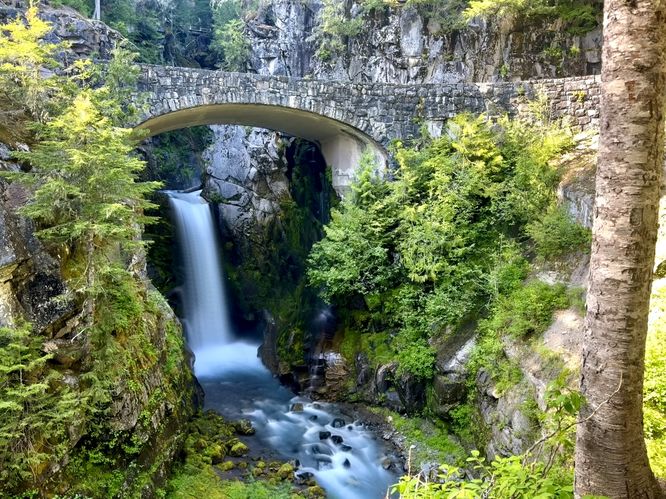
Christine Falls at Mt. Rainier National Park near Longmire, Washington is an easy 0.1-mile out-and-back walk that leads to one of the most photographed waterfalls in the park, Christine Falls.

Explore Christine Falls

Located on the Longmire-to-Paradise Road in Mt. Rainier National Park sits the ~40-foot tall waterfall known as Christine Falls. While the entire height of Christine Falls is closer to 70-feet tall, most visitors will explore the lower portion of the waterfall which is where this route leads you.

Starting at the trailhead, the dirt path leads down a fairly-steep hill for just a short ways before it terminates at viewpoints for the lower portion of Christine Falls. Here, you'll find a scenic stone bridge that spans the road and hangs over the turquoise-tinted waterfall. In the gorge below, you'll find small rapids that display the vibrant turquoise waters in more detail. From the edge of the Van Trump Creek's cliffs, you can appreciate the turquoise-tinted Christine Falls from several angles which makes for some fun photography. Stay a while to enjoy the waterfall, have a lunch or take a break from other nearby day hikes before leaving.

Explore Upper Christine Falls

After taking in the scenery of Lower Christine Falls, you might want to see the upper portion too. The hike to reach Upper Christine Falls is relatively easy at 0.6-miles out-and-back with the trailhead located just down the road. While the Van Trump Creek gorge is steep and rugged, it's also full of lush, vibrant vegetation like moss and fern-covered cliffs with views of its turquoise-hued waterfalls. It's well-worth your time if you're looking for another short but fun hike to do nearby.

Parking & Fees

Visitors will find a small parking turnout near the coordinates provided. The turnout is large enough to fit about a dozen vehicles as of June 2025. As of June 2025, there's a $25 entry fee for the park which is good for several days. If you plan ahead, you can speed up your entry with an Annual National Park's Pass.

Pets

All pets, including dogs, are not allowed on any trails within Mt. Rainier National Park, so please leave your dogs at home.

Warning

Cliffs: This trail follows steep cliffs that plummet over 40-feet into the Van Trump Creek gorge. For your own safety, stay on-trail.

Uneven terrain: This trail leads through a very short path that has uneven terrain, roots, and other tripping hazards.
Explore 11 trails near Longmire, WA
  1. Parking

    46.7804, -121.778861
  2. Main Trailhead

    46.7804, -121.778861
  3. Christine Falls (40-feet tall)

    46.780441, -121.779427
    Christine Falls (40-feet tall)
No community routes found. To add your own hike as a Community Route for this Trail guide, leave a Trip Report with an attached GPX file.

Hazards

Rockfalls / Ledges / or Scrambles

Seasons

All

Photo Albums

Trip Reports

Trail Guide By:
Admin user profile picture
0.1 miles / 0.2 km

Weather Forecast

In Longmire, WA

Explore Hiking Trails

You May Also Like

Colorado's Million Dollar Highway - Plan a day's drive adventure along the iconic Million Dollar Highway in Colorado. Explore the best short trails, roadside stops, waterfalls, vistas, ghost towns, and hot springs within a ~6 hour road trip.
Explore

Colorado's Million Dollar Highway

Plan a day's drive adventure along the iconic Million Dollar Highway in Colorado. Explore the best short trails, roadside stops, waterfalls, vistas, ghost towns, and hot springs within a ~6 hour road trip.

Read
Glacier's Going-to-the-Sun Road - Discover the breathtaking beauty of Glacier National Park along the iconic Going-to-the-Sun Road. From stunning roadside stops to picturesque waterfalls and vistas, this engineering marvel offers endless opportunities for exploration.
Explore

Glacier's Going-to-the-Sun Road

Discover the breathtaking beauty of Glacier National Park along the iconic Going-to-the-Sun Road. From stunning roadside stops to picturesque waterfalls and vistas, this engineering marvel offers endless opportunities for exploration.

Read
New York's Best Waterfalls - Whether you're planning a day hike, roadside stop, or a leisurely short walk, this guide provides hikers, travelers, and locals alike with 63 different locations to over 100 scenic waterfalls to help plan your next adventure!
Explore

New York's Best Waterfalls

Whether you're planning a day hike, roadside stop, or a leisurely short walk, this guide provides hikers, travelers, and locals alike with 63 different locations to over 100 scenic waterfalls to help plan your next adventure!

Read

Before you boogie...

Find our trail guides useful? Consider becoming a Supporter to unlock perks!

MyHikes is an indie platform that makes exploring public trails easier for everyone. The platform has no investors, no ads, and is owned and operated by one person, Dave Miller. Dave has personally mapped and written over 1,800 trail guides on MyHikes for the public to explore. MyHikes has helped millions outdoor enthusiasts plan their next adventure.

But it takes a lot of time ๐Ÿ•ฆ, money ๐Ÿ’ฐ, work, and espresso shots โ˜• to run MyHikes, including hiking , mapping , writing , and publishing new trails with high-quality (accurate) information... along with software engineering (coding) the platform like building new features, website and mobile app development (iOS and Android), site maintainance . and much much more.

Supporters unlock website and mobile app perks with an annual one-time payment of $25 (you renew) ๐Ÿ˜Ž๐Ÿ‘. Or you can simply make a Donation of your choice. Otherwise, you can support us by telling your friends about MyHikes - both quick and free ๐ŸŽ‰

Admin user profile picture

Dave Miller
MyHikes Founder