Loading...

❄️ WINTER SALE! 50% OFF on Supporter Accounts — now through January 31st. Unlock a full year of exclusive website & app perks. Learn More.

Two Lick Loop Trail

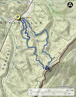
The Two Lick Loop Trail is a low use hiking and mountain biking trail in the Monongahela National Forest near the Virginia/West Virginia border. Although it provides only limited views, there are wonderful opportunities for solitude on this short loop and an opportunity to make a longer hike when combined with a second trail located inside the main loop. The adjoining national forest administered Pocahontas Campground, a pay facility featuring 9 campsites, offers pit toilets and trash cans but no water. There are no established campsites along the loop trail.

  • Mile 0.0 – The trail starts next to an information kiosk adjoining the day use parking area for Pocahontas Campground. There is a sign for the trail here. From the parking area curve around to a nice bridge crossing of Two Lick Run.
  • Mile 0.1 – Junction with the end of the Two Lick Trail loop, stay straight (right) to complete the loop counterclockwise.
  • Mile 0.2 – Junction with the Two Lick Bottom Trail. This is a newer trail that creates a 1.5 mile loop when used with the Two Lick Trail. The Bottom Trail’s beginning and end are at the Two Lick Trail. Stay on the Two Lick Trail and cross another bridge over a small stream. Begin gradual climb through open woods.
  • Mile 0.9 – Reach the terminus of the Two Lick Bottom Trail. Stay to the right, on the Two Lick Trail.
  • Mile 2.4 – You have reached the high point on this hike and are beginning the slow descent. On the left side of trail is a small view to the northwest, the only view on this loop. The trail hugs the side of the slope below the ridge for a short distance.
  • Mile 2.7 – Cross an old woods road. Maps indicate that this road connects with another road on the summit of the mountain (which could then connect with other trails such as the Great Eastern Trail), but no apparent trail exists. Shortly after reentering the woods, the trail continues under a large Chestnut Oak.
  • Mile 3.7 – The trail uses an old woods road to climb steeply to a ridge for a short distance. Because this area is more open, there is considerable undergrowth here. Stay on the old road bed before taking a sharp left at the ridge top. Ironically the trail, which has often had many blazes up to this point, is not well marked here.
  • Mile 4.9 – The trail meets up with the beginning of the loop. Turn right here to return to your vehicle. If you wish a longer hike, turn left and add the 1.5 mile Two Lick Bottom Trail Loop.
  • Mile 5.0 – The trail returns to the parking lot.
By HikingUpward Contributor: Jeff Monroe
Explore 28 trails near Rimel, WV

Know Before You Go

  • The Two Lick Loop Trail is a 4.7-mile low-traffic hike/bike trail near Rimel, WV, in the Monongahela National Forest, offering solitude but limited views.
  • The trail connects with the 1.5-mile Two Lick Bottom Trail, providing an option for a longer hike.
  • The Pocahontas Campground adjacent to the trailhead offers basic amenities like pit toilets and trash cans, but no water; there's also a parking area near the trail's start.
Interactive topographic map for Two Lick Loop Trail located in Rimel, WV. Click the "View Map" button to load GPS coordinates and trail markers.
Get directions
Distance
4.7 mi
Difficulty
Easy
Type
Loop
Est. Time
2.4 hrs
Elev. Gain
821'
Rating
0.0
Added
March 16, 2025
Updated
April 05, 2025

Weather Forecast

Loading...
Total Change
689'
Ascent
821'
Descent
827'
Loading...

Download the GPX Data for Offline Use

Supporters get exclusive access to download trail routes to the MyHikes app for offline use. Stay prepared on your adventure, even without an internet connection! Become a Supporter today to unlock this feature and hike with confidence.

Download Two Lick Loop Trail GPX Data to the MyHikes Mobile App

Features

Vista / Lookout Point
Dogs
Camping
Water Source

Points of interest

  1. Parking

    38.102522, -79.967192
  2. Main Trailhead

    38.102522, -79.967192

Safety information

For your own safety: plan ahead, let someone know where you'll be, and hike at your own risk.

Hazards

Snakes (Rattlesnakes, Copperheads, others)
Poison Ivy or Poison Oak

Availability

All seasons

Surface type

Dirt

Trip Reports (Reviews)

Your opinion matters! Be the first to rate this trail.

Ready to help fellow hikers? Add a trip report to share your experience and provide valuable insights for other hikers!

No community routes found. To add your own hike as a Community Route for this Trail guide, leave a Trip Report with an attached GPX file.

Popular categories

Scenic mountain view representing vista trails
Vista trails
Scenic gorge of cascades representing waterfall trails
Waterfall hikes
Rugged mountain terrain representing summit trails
Summit trails
Scenic mountain view representing dog-friendly trails
Dog-friendly
Scenic campsite with a view representing camping trails
Camping trails
Appalachian Trail logo representing A.T. hikes
A.T. hikes

You May Also Like

Colorado's Million Dollar Highway - Plan a day's drive adventure along the iconic Million Dollar Highway in Colorado. Explore the best short trails, roadside stops, waterfalls, vistas, ghost towns, and hot springs within a ~6 hour road trip.
Explore

Colorado's Million Dollar Highway

Plan a day's drive adventure along the iconic Million Dollar Highway in Colorado. Explore the best short trails, roadside stops, waterfalls, vistas, ghost towns, and hot springs within a ~6 hour road trip.

Read
🍪 We use cookies to learn about site usage and to serve map tiles. You may block cookies manually in the browser. By continuing you agree. Learn more