Loading...

🔥 End of Summer sale! 50% off on Supporter Accounts — now through September 1st. Learn More.

Turk Mountain Hike

Directions
Map
Pictures
Send to App
Distance:
9.8 Miles / 15.8 km
Type:
Loop
Difficulty:
Hard
Time to Hike:
4 hours, ~54 minutes
Features:
Appalachian Trail hike
Surface Type:
Dirt
Park:
Shenandoah National Park
Town:
Crozet, Virginia
Directions:
38.097703, -78.781007
Added:
March 19, 2025
Updated:
April 06, 2025
Guide by:
Copy Trail Link Hiking this trail? Send a friend or family member a link to this trail guide for your own safety. Hike at your own risk (disclaimer)
Loading...
Loading...
1,518'

Total Change
2,403'

Ascent
2,404'

Descent

Download the Trail Route for Offline Use

Supporters get exclusive access to download trail routes to the MyHikes app for offline use. Stay prepared on your adventure, even without an internet connection! Become a Supporter today to unlock this feature and hike with confidence.

Send to App

Turk Mountain Hike

Turk Mountain is a tough hike with about 2400’ of elevation gain, bring plenty of water, especially if hiked in the summer. We hiked it a few days before Christmas and it was quite cold. It's hard to rate the solitude as the temperature was so cold all normal people were at home and not out hiking. The best views are at the top of Turk Mountain, so make sure you do the out/back Blue-blazed Turk Mountain trail.

All of the trails for this hike are well maintained. Hiking poles would be advisable for the multiple stream crossings, althought the level will be significantly less in the summer. This hike is the last circuit hike in the southern section of the Shenandoah National Park.

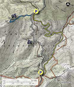
We parked at the Jarman Gap parking area, near MP97. There are two yellow gated barriers, the trail starts on the barrier nearest Skyline Drive and goes downhill. Continue past the barrier hiking on the yellow blazed Moormans River Fire Road. In about 0.2 miles you will come to an intersection of the A.T., continue past this intersection, crossing Moormans River multiple times prior to reaching the intersection of the Turk Branch Trail in 2.0 miles. You will cross the river and immediately take a left after the SNP Stone Marker heading up the yellow blazed Turk Branch trail. Note: The Moormans River Fire Road continues straight at this intersection following the Moormans River, make sure you turn left onto the Turk Branch Trail.

Continue on the Turk Branch Trail, crossing Turk Branch a couple of times, with multiple switchbacks prior to reaching the Turk Gap parking area. This part of the hike is about 2.6 miles long and gains roughly 1200’ feet in elevation. One of the crossings had a nice small waterfall with a few others visible upstream.

From the Turk Gap parking area, cross Skyline Drive and head to the Stone marker, bearing left onto white blazed AT going South. DO NOT TAKE the yellow blazed continuation of the Turk Gap Trail. Stay on the AT South for 0.3 miles until you reach the intersection of the blue blazed Turk Mountain Trail, take a right. This is an out and back adding 2.0 miles to the hike, but you will see the best views of the day and have a great place to eat lunch. Be sure when you are at the top of Turk Mountain to continue along the rocks past the Stone marker, so that you can also see some great views of the Shenandoah Valley. Retrace your steps to the AT intersection.

Take a right at the AT intersection heading south for about 1.4 miles before crossing Skyline Drive. To the right is the Sawmill Run Overlook which if you have time, has some great views. Once across Skyline Drive there are some good up and downs on this part of the AT but not too bad. Continue on the AT for 1.7 miles reaching the Moormans River Fire Road intersection. Take a right and reach the Jarman Gap Parking area in 0.2 miles to complete the hike.

Explore 40 trails near Crozet, VA
  1. Parking

    38.097703, -78.781007
  2. Main Trailhead

    38.097686, -78.781114
No community routes found. To add your own hike as a Community Route for this Trail guide, leave a Trip Report with an attached GPX file.

Hazards

Ticks - Lyme Disease More Info (CDC)
Snakes
Poison Ivy/Oak

Seasons

All

Photo Albums

+ Add Photo Album

Upload your photos from the trail to help others know what to expect.

Trip Reports (Reviews)

Rated 3.92 out of 5 based on 25 ratings.
By: Dan Weigand
9.8 miles / 15.8 km
September 29, 2018
Did this hike on Saturday. Have done it once before in the dead of winter so I was excited to get some warmth and sunshine at the summit this go-around. Because of all the rain a couple days before, the eastern portion (first 3-4 miles) were VERY wet. The trail was basically a stream until I got about halfway back up the other side, and I had to cross actual streams and the river over a dozen times. The river crossings were especially difficult, but I managed to find tress and/or rocks up/downstream and stayed mostly dry. If you don't want to be wet, DO NOT do this hike right now. All that considered, the rest of the hike was warm and dry, and the views from the summit (both eastern and western vista) were fantastic. Lots of low clouds and fog that day and it was neat to be above the clouds at the top as they rolled over the mountains. Lots of wildlife in this area as the vast majority of the hike is not heavily traveled. Saw tons of people on the Turk Gap parking to summit portion (2 miles), though. The remainder of the hike down the AT is pretty steady, but the uphill around mile 9 or so is tough after everything you've done so far. Overall I loved this hike, and would recommend it to anyone looking for a long, challenging day hike.
Legacy Review
By: Patrick
9.8 miles / 15.8 km
September 23, 2017
I am going to rate the hike as a four star. The leaves are starting to change in Shenandoah. The only thing keeping this from a 5 star hike is the big yellow jacket nest on the Turk Branch Trail. Be careful out there if you do this hike. I would recommend this hike later in the Fall/Winter when the colder weather ensures that the jacket nest is not an issue.
Legacy Review
By: mark
9.8 miles / 15.8 km
March 25, 2017
Overall, a very nice hike. I only scored it a 3 stars because, as someone else noted, there are nicer hikes just a few miles up the road. (e.g. Riprap, Trayfoot, Doyles River) In some ways that is unfair. In 90% of the country, this trail would be famous, but here, it is a second thought. That said, I hiked it as described and believe that is the better direction to hike it, plus after 6 miles and the climb up Turk, I was ready for a lunch break with a very nice view. Trails were in good shape and no problems. Lot of windblown coming up from the Moormans, but the trail was nicely cleared. If hiking in summer, be ready for the sun to beat down on you hiking the AT back to Jarmans Gap. They are right about bringing enough water, it was in the 70s and I drank 1 1/2 liters with no pit stops.
Legacy Review

Weather Forecast

In Crozet, VA

Explore Hiking Trails

You May Also Like

New York's Best Waterfalls - Whether you're planning a day hike, roadside stop, or a leisurely short walk, this guide provides hikers, travelers, and locals alike with 63 different locations to over 100 scenic waterfalls to help plan your next adventure!
Explore

New York's Best Waterfalls

Whether you're planning a day hike, roadside stop, or a leisurely short walk, this guide provides hikers, travelers, and locals alike with 63 different locations to over 100 scenic waterfalls to help plan your next adventure!

Read
25 Best Day Hikes in North Carolina - Discover the top 25 best day hikes in North Carolina, from breathtaking waterfalls to mountain peaks. Explore hidden gems, scenic views, and trails suitable for all skill levels, perfect for your next outdoor adventure.
Explore

25 Best Day Hikes in North Carolina

Discover the top 25 best day hikes in North Carolina, from breathtaking waterfalls to mountain peaks. Explore hidden gems, scenic views, and trails suitable for all skill levels, perfect for your next outdoor adventure.

Read

Before you boogie...

Find our trail guides useful? Consider becoming a Supporter to unlock perks!

MyHikes is an indie platform that makes exploring public trails easier for everyone. The platform has no investors, no ads, and is owned and operated by one person, Dave Miller. Dave has personally mapped and written over 1,800 trail guides on MyHikes for the public to explore. MyHikes has helped millions outdoor enthusiasts plan their next adventure.

But it takes a lot of time 🕦, money 💰, work, and espresso shots ☕ to run MyHikes, including hiking , mapping , writing , and publishing new trails with high-quality (accurate) information... along with software engineering (coding) the platform like building new features, website and mobile app development (iOS and Android), site maintainance . and much much more.

Supporters unlock website and mobile app perks with an annual one-time payment of $25 (you renew) 😎👍. Or you can simply make a Donation of your choice. Otherwise, you can support us by telling your friends about MyHikes - both quick and free 🎉

Admin user profile picture

Dave Miller
MyHikes Founder